Wednesday, November 21, 2012

Beacon, Glendale, Bee in Griffith Park - November 21, 2012

View east toward Bee Rock from Vista Del Valle Drive
Griffith Icon Very uncharacteristic for me, it’s been nearly seven weeks since I’ve been hiking. So I was eager to hit the trail, and a half day off work before Thanksgiving offered an ideal opportunity to hike in Griffith Park. For my many hikes in the park over the years, I’ve not repeated one yet. I’ve used many of the same trail sections, but combined them for different hikes. For today’s hike I tried out a use path to Beacon Hill, a use path to Glendale Peak (which I’ve been down but not up), a section of Vista Del Valle Drive (which I’ve not been on before), and descended Bee Rock Trail (which I’ve climbed but not descended).

I leave my office in Echo Park at 1:43 and navigate to the merry-go-round parking lot off Crystal Springs Drive on the east end of Griffith Park. I walk back to the parking lot entrance and walk across the street to the trailhead.
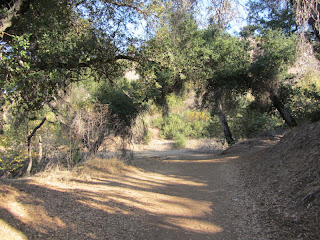
Lower Beacon Trail
2:15 PM – Begin hike on Lower Beacon Trail (#2) heading southeast. Within 3 minutes I reach an outward bend and am pleased to find my path heading up the ridge. I pre-scouted the route on Google maps aerial and it showed a clear, distinct trail. I turn right and begin to climb the narrow path up the broad ridge. The temperature is pleasant and the sunshine feels good. There’s a gentle breeze. Haze obscures the views today. The din of traffic on the I-5 provides an ever-present soundtrack. The route is somewhat steep but not bad. It feels good to be hiking. The yellowing leaves of black walnut add a splash of fall color. Soon Bee Rock to the northwest comes into view over my shoulder. As the trail mellows out, Beacon Hill comes into view up ahead. The 2007 fire incinerated this area, but vegetation is coming back well. It seems like the climb went quickly as I reach Upper Beacon Trail in 20 minutes. I turn left (east) on the dirt road and make the final steep climb to the summit.

View north from Beacon Hill, Griffith Park
2:35 - Beacon Hill (1001’). This isn’t a grand summit, but it stands as the eastern most point of the 40-mile-long Santa Monica Mountains. Glendale spreads out below me. The San Gabriel Mountains, dominating the skyline from the North to East, are virtually invisible today, as is downtown L.A. to the south. A man arrives and keeps going. I’m bummed that my camera lens cover is not retracting all the way.

I leave the summit at 2:55 and head west along the eucalyptus-lined road. Six minutes delivers me to 5-Points junction. I continue straight on the middle fork. There is nothing in bloom. Winter grass begins to push its way through the soil dampened by recent rain. A young couple passes walking some dogs. I pass below a water tank, round the bend to the south, and arrive at Vista View Point and the paved Vista Del Valle Drive.

View north toward Glendale Peak and the 4-point junction
I turn right (north) on the paved road and in about 100 yards reach a 4-point junction at 3:16. Folks are coming up Riverside Trail from the west. The grand observatory sits as a hazy silhouette to the west. I turn left, pass the green shed, and head west on Hogback Trail, signed “Bridle Trail.” In a few minutes I reach an outward bend and my short-cut route. I’ve been down this way but not up. I turn north and am thankful for long legs as I negotiate several big steps cut out of the steep granite to begin the climb. The use path is steep and the footing is comfortable in the soft dirt until near the top where the footing gets dicey on the exposed rock.

View south from Glendale Peak toward downtown L.A.
3:25 - Glendale Peak (1184’). The breeze is cool and the views are obliterated with haze. Ant-like humans dot the summit of Mt. Hollywood to the west. I post a picture to Facebook. It’s peaceful here. I consider heading north on Henry’s Trail to the bridge and seeing if there is a route down to the road. But I don’t have enough daylight to be taking chances on possible alternate routes.

I leave the summit at 3:40 heading down the same path. It’s a little more precarious descending. Back at the road I retrace my steps to the 4-point junction. There’s a fair amount of foot traffic here. For several years following the 2007 fire, this portion of Vista Del Valle Drive had been closed due to fire damage, thus I’ve not yet hike it.

View of Hogback bridge from Vista Del Valle Drive
I turn north on the paved road. I’m in total shade now and it’s cool. My pace is brisk. Shortly I arrive at the ravine with the footbridge above and discover that there is indeed and well-beaten route down the steep slope from the south end of the bridge. I can’t resist trying it out, so up I climb. It’s a little precarious and not for the faint of heart, but careful steps deliver me to the beginning of Henry’s Trail and the bridge. Three walkers pass. I take a few pictures and climb back down to the road. The side trip took 10 minutes.

View north on Vista Del Valle Drive
I continue north as the road gently ascends contouring along the mountainside. The sun still rests on Beacon Hill to the east. I can see the merry-go-round parking lot below. As I round a bend at the power tower, “Baby Bell” comes into view to the northwest with the sun still resting on it. The sun sets in about 35 minutes so I press the pace. Across Spring Canyon, tiny figures stand on Bee Rock. I’m enjoying the views of the various features at east of the park from a different perspective, but I wish I had better lighting. After what seemed like a long walk, I finally reach the bend and transition unto the trail descending east along the ridge for a 3-minute walk to the rock.

View east from Bee Rock, Griffith Park
4:33 - Bee Rock (1056’). The mountain casts shade on the west portion of Glendale while dim rays of sun rest on highpoints on the east side. The San Gabriels are but a faint outline through the thick, orange haze. It’s breezy and quite cool now. I briefly take in the views, snap a few pics, put on a long-sleeved shirt, and leave at 4:37.

It’s only 10 minutes till sunset but I know I’ll have plenty of light to navigate the narrow trail down. This is the first time I’ve descended Bee Rock Trail. My other visits to Bee Rock were the first stage of loop hikes that took other routes down. My camera doesn’t really capture the beauty of dusk. The yellow leaves of black walnut almost glow. My pace is relaxed now. It takes me 15 minutes to the dirt road where I turn east. In a few minutes I reach the junction of Old Zoo Trail.

En route from Old Zoo Park to Merry-go-round Parking lot
I pass through the fence and saunter through Old Zoo Park. Western sycamores display beautiful fall colors but the lighting is too dim now to capture it. A family strolls across the grass with their dogs. Some young men are exploring old animal cages. The walk is peaceful as I head southeast to complete the loop. Glendale is now a blanket of twinkling lights seen through the trees. I have happy memories of other hikes in Griffith Park that ended in nightfall.

5:15 - End Hike.

California black walnut at dusk, Bee Rock Trail
Epilog - A very pleasant outing. I love Griffith Park and enjoy exploring new routes and experiencing the nuances of this wonderful place. I am pleased and somewhat surprised that all the dog walkers I encountered today were using leashes…that may be a first for me! I look forward to the green of spring when the flowers begin to add color to the hillside and the daylight lingers. icon

Griffith Icon  See Hiking Griffith Park at Dan's Hiking Pages
  (includes links to my other blog posts for hiking in Griffith Park)

Boot Icon See hike descriptions on Dan’s Hiking Pages
(Detailed trail guide including driving directions, recommended season, map, notes, links, and photos)
NEXT > Mt. Hollywood and Mt. Bell - April 12, 2013 (via Brush Canyon)
PREVIOUS > Griffith Observatory Space Shuttle Hike - Sept. 21, 2012

Saturday, October 6, 2012

Hawkins Ridge Trail Work with the Trailbuilders - Oct. 6, 2012

San Gabriel Mountains Trailbuilders preparing to begin work day
One month ago when I hiked South Mount Hawkins and Hawkins Ridge, I had no idea when I’d get to return. When I saw the email this week from the San Gabriel Mountains Trailbuilders announcing that the October 6 work day was planned for Hawkins Ridge, I was elated and knew I had to be a part of it. I had reported to the group that a section of the trail south of Sadie Hawkins had completely disappeared. I figured, however, that it would be unlikely to get trail crews up there since South Mt. Hawkins Road was washed out with no plans by the Forest Service to restore it. But during the Williams Fire 2012, which begun on Sept. 2, FS officials took advantage of dozers on hand and ordered that So. Mt. Hawkins Road be graded. So the Trailbuilders took advantage of the restored access and decided to head to Hawkins Ridge Trail. The Trailbuilders built the trail in the 1990s but the trail hasn’t had formal maintenance in at least 10 years since So. Mt. Hawkins Road was closed as a result of the 2002 Curve Fire.

8:03 AM - Leave from the San Gabriel Canyon Gateway Center in Azusa and drive up Highway 39 to Rincon Fire Station to load the equipment. There are 22 of us today, including some students from Mt. San Antonio Collage. We load up the equipment: shovels, McLeods, pick-mattoxes, loppers, rock bars, chainsaws, etc. After the drive up to Crystal Lake Campground, we stop at Deer Flats and transfer those in cars to the high-clearance trucks and SUVs.

San Gabriel Mountains Trailbuilders driving South Mt. Hawkins Road
9:30 - Begin our drive up South Mt. Hawkins Road in a caravan of six. I’m in the second vehicle. The road is really rough even though it had been recently graded. We stop occasionally and I clear large rocks from the road, which the super high-clearance truck in front of us had no problems with. We stop briefly at the saddle. Our leader, Ben White, tells us to continue the drive up the South Mt. Hawkins so that the group can experience the site of the historic fire lookout. This is a rare opportunity to be here in vehicles.

San Gabriel Mountains Trailbuilders visiting ruins of South Mt. Hawkins Fire Lookout
10:27 - South Mount Hawkins (7783’). Everyone piles out of the vehicles and lingers about the site enjoying the panorama. The views of surrounding mountains are pretty good today while the lowlands are shrouded with a layer of clouds. I reflect on my experience being here last month watching the Williams Fire grow. We leave the summit at 10:41 and head back to the saddle as the staging area for our work. Ben leads a safety meeting on the use of tools and guidelines for a safe day.

San Gabriel Mountains Trailbuilders heading to work on Hawkins Ridge Trail
11:11 - Begin hike heading north up the road toward the trail. In a few minutes we reach a gentle saddle just north of a helespot clearing. This is the beginning of Hawkins Ridge Trail and our first task for the day: clearing a large deadfall that blocks the trail. The chainsaw gang attacks the tree while volunteers with McLeods and shovels begin to give definition to the faint path. Trail veterans give instructions to the new comers.

Searching for traces of the vanished section of Hawkins Ridge Trail
I hike ahead with Alan to where the trail vanishes in a meadow-like area. We carefully scan the area for traces of the old trail and use orange ribbons to flag the route for the hand crews to follow. I can see why I could not find the trail last month since it disappears into a jumble of fallen trees. Alan, a veteran trail boss, flags the original route through a couple hundred yards of the woody obstacles. The route arrives at a clear spot on the ridge offering views west. We take a break for lunch.

Searching for traces of the vanished section of Hawkins Ridge Trail
From here the route would have cut back northeast taking a tangent across the broad, undulating ridge. We can’t find any semblance of the trail. Alan forges ahead and locates the clear trail that picks up on the southeast flank of Sadie Hawkins. Between that point and the clearing where we had lunch, we crisscross back and forth but still are unable to identify the old trail. Alan flags a route that seems to reasonably match his recollections of the trail from his helping build it years ago. I head back down to see how the rest of the crew is doing.

San Gabriel Mountains Trailbuilders removing deadfalls from Hawkins Ridge Trail
The group has arrived at the jumble of trees. The three chain sawyers had leaped-frogged their way to here clearing the deadfalls while the other volunteers graded a fine trail. We now have a discussion as to whether we should reroute the trail above the tons of tree trunks and branches, or if we should carve our way through them. Since the FS policy is to always maintain the original trail route whenever possible, we decide to cut through the fallen forest. I wander back down the trial further to join the rest of the crew and assist in reestablishing a route.

Freshly restored tread on Hawkins Ridge Trail
I then head back up the trail past the jumble to the upper work section. I am pleased to find that the volunteers had roughed out the route we had blazed and a clear path is now established for hikers. Ben tells us that we’ve got six minutes before heading back at 2:30. I walk along the new route to where it joins the established trail which traverses along the east flank of Sadie Hawkins. In my hike last month I had gone up the ridge to the summit and so did not tread on this section of trail. I’m a little sad about that since it’s hard to write a reliable trail description without having hiked the whole trail. So I press on ahead and figure I can catch up with the others who were heading down.

Pristine section of Hawkins Ridge Trail along northeast flank of Sadie Hawkins
The trail is in great shape as it gently ascends north along the eastern slope of the summit. It’s remarkable how nicely a well-built trail in certain conditions holds up without maintenance. I’m feeling a little angst because I would hate to have the whole group be waiting for me back at the vehicles, but on the other hand, I’d kick myself if I didn’t take the opportunity to explore further only to find the others lingering before heading down. I press on. I reach a point at which the trail begins its descent to the saddle north of Sadie Hawkins. I’m satisfied with having a visual of that couple hundred yards of trail, so I turn west and head straight up the steep, barren slope to the summit. When I achieve the top I find that I am north of Sadie Hawkins summit and near the point at which the use path drops steeply north to the saddle. I turn south, walk through a slight dip and climb the final steep pitch.

Freshly restored portion of Hawkins Ridge Trail
2:37 - Sadie Hawkins (8047’). A month ago I had no idea I’d be standing here again so soon. This time the southern sky is not filled with billowing smoke. I don’t linger as I leave the summit and head south on a route that looks like it was cleared by a dozer many years ago. Soon I veer left, climb down a steep section, and rejoin the newly reestablished trail. When I arrive at what used to be a jumble of timber, I am quite surprised to find that the chainsaw gang had made huge progress and the route was nearly clear except for about three last deadfalls. And I am happy to see the three sawyers still here getting ready to leave. So I won’t be the last one off the mountain! I proceed down on a beautifully restored trail. I’m greatly satisfied that the crew was able to accomplish so much today. I catch up with Ben at the point near the beginning of the trail and we walk down together as the sawyers catch up.

San Gabriel Mountains Trailbuilders at the end of the day of working on Hawkins Ridge Trail
3:08 - Arrive back at the vehicles. An ice chest full of cold Gatorade and bottled water is welcome by all. We load the tools and begin the bumpy, 4.7-mile ride down the road to Deer Flats and then continue down. At Rincon Fire Station we unload the tools and call it a day.

Epilog - What an excellent day! I am so pleased that we were able to reestablish the missing section of this splendid Hawkins Ridge Trail. The crew worked hard and the weather was perfect. And for the group to visit the ruins of the historic South Hawkins Fire Lookout was a real treat. We encountered only one party of two hikers today who were coming down the ridge, having started from Hwy 2. Since the distances to hike here are long, this trail naturally won’t get a large amount of foot traffic. But it is one of the finest trails in the San Gabriels and offers the intrepid hiker a wonderful high-country experience. If you want to enjoy some rewarding work, come out and spend a day with the San Gabriel Mountains Trailbuilders. Workdays are on the first, third, and fifth Saturdays of each month. Visit the San Gabriel Mountains Trailbuilders website to learn more. icon

See Hawkins Ridge Hike - September 2-3, 2012 at Dan’s Hiking Blog

See Windy Gap Trail hike description at Dan’s Hiking Pages

Sunday, September 30, 2012

Windy Gap Trail Work with the Trailbuilders - Sept. 29, 2012

Safety meeting to begin Trailbuilders workday
See Windy Gap Trail hike description at Dan’s Hiking Pages

Since June 2003, I’ve enjoyed volunteering with the San Gabriel Mountains Trailbuilders. This group of dedicated men and women have been building and maintaining trails since 1984. We primarily focus our efforts in the San Gabriel River District of the Angeles National Forest, with much of that in the Crystal Lake basin. The project for today is Windy Gap Trail. I hiked down the trail a month ago and it was in pretty good condition, but since then, there was a big rain storm that caused some damage.

8:00 AM - Leave from the San Gabriel Canyon Gateway Center in Azusa and head up Highway 39 to Rincon Fire Station to load the equipment. There are 25 of us today, including seven Boy Scouts from troop 90 of Newport Beach and their leaders. With equipment loaded, we continue the drive up to Chrystal Lake basin. Once at the campground, our keys allow us to pass through locked gates and to drive along South Hawkins Road through Deer Flats and arrive at the location where Windy Gap Trail crosses the road for the second time.

Volunteers heading up trail for Trailbuilders workday
10:10 - After a safety meeting, we begin up the trail. Two chain saw crews take the lead since they will be going on ahead to remove deadfalls higher on the trail. The rest of group breaks into several parties and attacks various damaged areas along the route. Experienced Trailbuilders patiently provide instruction and oversight for the young scouts.

The weather is great today. Scattered high clouds mute the sun. A pleasant breeze is refreshing. My tool of choice today is a McLeod: half rake, half hoe. It was originally a firefighting tool invented in 1905 by Malcom McLeod (pronounced “McCoud”). It’s a ideal tool for spreading soil and grading trail tread.

Trailbuilders repairing trail damage
After accomplishing some light trail clean up, I catch up with Lou, Buddy, and Alan, three veteran Trailbuilders who are working on a spot where the trail crosses a ravine and is significantly damaged. I’m always amazed to see the kind of destruction that rushing water can do. We chisel away at the dried mud mixed with rocks that is heaped on the trail on both side of the ravine. Lou leads the effort in rebuilding a rock retaining wall to support the trail crossing the narrow wash. We wrestle heavy rocks to move them into place.

12:05 - Take a break for lunch. After the break we continue on the project. We dislodge a huge rock that was perched precipitously above the trail. As we anticipated, the rock came to rest right in the middle of the trail. Three of us laying on our backs and using our legs are able to roll the rock over the edge.

Trailbuilders repairing damage on Wendy Gap Trail
1:20 - Finish the project. I continue up the trail to see what else I can help with. I pass over several sections which have been freshly restored by our crews today. It’s very easy to take for grant it a good trial. I round a bend and find the main group of our volunteers laboring on a large washout. Debris from the sheer cliffs above has obliterated the Sutter walls (wooden retaining barriers) and buried the trail. The task today is to clear a temporary route over the rubble. I lend a hand. Shortly the chain saw crews arrive from the upper trail. They removed four deadfalls today, which was everything to Windy Gap.

Descending Windy Gap Trail at end of workday
2:00 - End the work at the designated time. We gather our equipment and head down the trail. We’re dirty and tired. Views toward the valleys beyond are muted by haze. I think about my hike down this trial on Sept. 3 when smoke from the Williams Fire completely obscured visibility. I look west across the bowl toward Islip Ridge and Mt. Islip and reflect upon my thoroughly enjoyable hike there back in July. Along the trail I admire the work our crews have accomplished today.

Tired and dirty volunteers after a satisfying day of work
2:32 - Arrive back at the vehicles. An ice chest full of cold Gatorade and bottled water is a hit. We load the tools. A group picture caps the day. Back at Rincon Fire Station we unload the tools and say our goodbye to one and all.

Beautiful skies over Crystal Lake basin
Epilog - A very rewarding day of hard work surrounded by breathtaking scenery. I always enjoy the camaraderie. And it’s good to have Boy Scouts join us. For the entire day, we encountered only three parties of hikers using the trail. Maybe eight years of closure due to the 2002 Curve Fire caused people to forget about Crystal Lake as a great hiking venue. I implore hikers to take a break from the crowd-infested places like Mt. Baldy and Icehouse Canyon and enjoy the grand scenery, splendid trails, and majestic peaks of the Crystal Lake basin. And if you would like to serve those who love the outdoors, come out and spend a day with the San Gabriel Mountains Trailbuilders. Workdays are on the first, third, and fifth Saturdays of each month. Visit the San Gabriel Mountains Trailbuilders website to learn more. icon

See Windy Gap Trail hike description at Dan’s Hiking Pages