Sunday, September 25, 2011

Farewell to hiking author Jerry Schad

Jerry SchadI was saddened to learn that beloved hiking author Jerry Schad passed away on Thursday. He was only 61 and succumbed to kidney cancer.

His book, Afoot and Afield in Los Angeles County has helped thousands of Angelinos hit the trails for wonderful hiking experiences. I purchased my first copy on March 31, 2005 and it has been a real treasure in finding and exploring new trails. He has written 16 books, which primarily focused on outdoor recreation, including two other well-regarded "Afoot and Afield" books, on San Diego County and Orange County.

He had a passion for the outdoors and had a huge generosity of spirit in spending his life to help others enjoy outdoor recreation.

Afoot and Afield in Los Angeles CountyJerry’s hike descriptions are clear, concise, accurate, colorful, and always have interesting tidbits to pique interest in hiking the trail. In my review of his work, I write, “He was written up so many hundreds of trails for hiking, biking, and running in Southern California, I have a hard time imagining he has a life outside of his trail ventures and writing.” Jerry was simply prolific in producing a huge body of work.

Outdoor enthusiasts have lost a great ambassador and true hiking guru. My thoughts and prayers are with his wife and family. Jerry, you are greatly loved and will be greatly missed. icon

Read more:


Visit Dan's Hiking Pages
 

Saturday, September 17, 2011

Mt. Baldy via Mt. Baldly Trail from Village - Sept. 17, 2011

West Baldy / Mt. Baldy / Mt Harwood

View northeast toward West Baldy, Mt. Baldy, and Mt. HarwoodSee Mt. Baldy via Old Mt. Baldy Trail hike description at Dan's Hiking Pages

What a remarkable hike on a superb route to Mt. Baldy! This has been a summer of amazing hikes in the San Gabriel Mountains high country. So it was fitting to end the summer with a hike up Old Mt. Baldy Trail from the Village to the summit—6,000 feet in six miles. John Robinson describes the hike as "one of the most strenuous hikes in the San Gabriels." I’ve hiked all over the San Gabriels but this legendary hike had eluded me for years. So it was time to conquer it, my third assault on the grand summit in six weeks. I learned that The Hikemasters hiking group led by my friend Ray was planning to hike Baldy via the Village and so I jumped at the chance to join them.

Ray picked me up at 5:15 and we headed to Upland to the rendezvous spot. After we were all together we headed up to Baldy Village to the Mt. Baldy Visitor Center. Several drove cars up to be parked at the ski lifts for our return shuttle. We ended up with 14 for the day, some of which had no hiking experience and others were seasoned iron men. Finally we were ready to hike.

Beginning hike from Mt. Baldy Visitor Center7:10 AM - Begin hike. Our gang of 14 tromp up Bear Canyon Road the 11 minutes to the beginning of the trail. The temperature is cool. The woodsy charm of this canyon is always a delight. The trail climbs at a moderate grade which is a good warm-up for the steepness to come. Arrive at Bear Flat (5580’) at 8:00 to complete the first 1.8 miles.

Looking south on Old Mt. Bald Trail above Bear FlatAfter a 10-minute break we cross the flat and begin climbing the steep slope via numerous switchbacks. The sun is warm but air temperature is still pleasant as we climb through the open chaparral that was burned by the 2008 Big Horn Fire. The group now strings out as the iron men and young bucks charge up the mountain and the older guys hang back. A blanket of clouds covers the human sprawl beyond the mountains to the south. I look east toward the Three Tees where I was hiking last weekend.

9:17 - Round the ridge hip and views west open up. The trail now begins to climb the ridge, which will be the primary mode for the rest of the hike. Enjoy conversation with follow hikers. Others hikers pass by. We chat with some. The scenery gets more beautiful as we climb. I love the vanilla scent of ponderosa pine (or perhaps it’s Jeffrey pine...both species emit a similar sweet-smelling aroma).

look south from above high point 775510:28 - Reach the saddle beyond high point 7755’. This is as far as I have hiked previously. This makes a splendid destination if one wants to do a nice 7.5-mile round-trip hike. Runners are coming down the trail. I sit for a nutrition break. Lots of traffic on the trail today. Later I learned that many of those are with the Peak Baggers group from Meetup.com. They have about a dozen in their group today strung out along the trail. I conclude my snack break as Ray, Gus, and Andy, the tail end of our group, catch up with me. Meet a hiker named John who summited in 3 hours 10 minutes this morning. Mature pine and fir provide shade. Massive boulders decorate the ridgeline. The route alternates views east and west. The landscape is breathtaking. Tiny chipmunks skitter around.

View southwest into Cattle Canyon11:42 - Arrive at notch in the ridge with a spectacular view west into Cattle Canyon and beyond. Dramatic topography! The others leave me as I pause to soak it in. I leave and in five more minutes I catch up with the others at a large outcropping just off the trail. More stunning views. The others leave me again and I decide to take another nutrition break and savor the amazing beauty. Soon the trail bends east and poses the steepest climb of the route to archive a ridge with the first view northeast toward Mt. Hardwood. Climbing now on what Robinson calls “hardscrabble.”

The Narrows12:31 - Reach “The Narrows,” a razorback saddle at 9200’, as Robinson describes it. West Baldy, Baldy, and Harwood are now in full view (photo at top). The trail mellows out and continues along the east side of the ridge in open sun through stands of dwarf limber pine and fir. The amazing beauty of the landscape captivates me. Breeze feels good. I take a side jaunt west to an impressive rock formation jutting above the ridgeline and am rewarded with splendid scenery. I continue along the ridgeline above the trail and reach the upper hip of Big Horn Ridge. Wow! Great vantage point looking down into Coldwater Canyon, San Antonio Ridge, and Iron Mountain. I love off-trail excursions. I wander back over to the trail which now heads northeast. I catch up with our tail-end group, which now numbers four. I still feel strong so I decide to pass them and stay at a good pace to afford me time to tag West Baldy. The trail now traverses the broad southeast face of West Baldy. I look for a short-cut route but see none. I reach the Baldy/West Badly saddle at 1:56. Turn left (west) and start the final pitch.

Peak Baggers on West Baldy2:03 - West Baldy (9988’)...third time in six weeks. The Peak Bagger group is gathered on the summit and seems to be having fun. I meet Tim, who is a fan of Dan's Hiking Pages. Chat with some. They leave heading south down the slope. I leave at 2:25 and head for Baldy. I spot the Foursome as “ants” just past the saddle. Ray’s bright salmon shirt and Gus’s bright yellow shirt have made it easy to spot them a quarter mile away. I reach the saddle at 2:28 and begin the final climb to Baldy. I have found that this path that travels along the ridge is more enjoyable than the main trial south of the ridge. This route provides expansive views and pleasant breezes.

Mt. Baldy summit2:40 - Mt. Baldy (10,064)...the grand crown of the San Gabriels! The Foursome arrived minutes before. An American flag is flying in honor of 9/11. About 15 people linger on the summit. The rest of our group have already left. People pose for pictures. I have a bite to eat. I soak in the accomplishment of having climbed the “hard way” to Mt. Badly, yet my thoughts turn to planning a hike to reach this summit via the north approach along the “other backbone.” I stroll over to the northern edge to survey the route. Ray signals to me that it is time to leave.

The FoursomeDepart summit at 3:06. I now have my sights set on Harwood...might as well make it a triple crown day since I’m still feeling plenty strong. I try to stretch my lead on the Foursome but it’s difficult to make good time descending this steep, rocky slope. I’m always in awe of the picturesque scenery of this majestic mountain. Reach the Baldy/Harwood saddle at 3:29 and begin to scale the west slope of Hardwood. The climb seems easy even after a long day of steep ascent.

View East from Mt. Harwood 3:44 - Mt. Harwood (9552’) - Wow, I’m always impressed with this peak. The sweeping panorama and lunar-like landscape have such a different feel from Badly. I stop only briefly to snap some pics, having been here just a few weeks ago. I spot Ray and company far below on the trail and give a wave. I proceed east along the crest and in six minutes reach the eastern edge which drops off precipitously 1,000 feet and provides a great view down on the Devils Backbone. No sign of my comrades. I turn south and pick a route down through the manzanita and conifers. I sense some déjà vu —I did this route three years ago. I remember to take a tangent southwest to avoid a precipitously steep descent. Reach Devils Backbone Trail at 3:58. My pace is fast now as I try to catch up with the others. Still taking pictures and studying the landscape. I’ve been contemplating a route up Manker Canyon.

Looking south down the Turkey Shoot as telegraph Peak looms aboveReach the end of Devils Backbone Trail at 4:31. A few minutes later I arrive at the upper chair lift (8600’) and I decide to descend via the Turkey Shoot ski run, figuring this short-cut would catch me up with the others. I forgot how long this route is, dropping 800 feet. Maybe it’s because my legs are feeling the effect of a lot of hiking today.

4:57 - Baldy Notch (7800’). Finally, I’m done hiking. Over at the lodge I find the others. They arrived just minutes earlier. I learned from Ray that they also descended the Turkey Shoot, so that’s why I couldn’t catch them. I pay my $10 and enjoy a peaceful, relaxing ride down the chairlift to the waiting cars.

View southwest from Old Baldy TrailEpilog - What an incredibly amazing day of hiking! The extraordinary scenery along this route is next to none in the San Gabriels. The trail is indeed steep, but I never found the “unbelievably steep” sections that Robinson describes. The weather was absolutely perfect. The marine layer over the L.A. basin helped created a sense of remoteness. I enjoyed the company of hiking partners and conversations with other hikes. I relished seeing my beloved San Gabriels high country from vantage points I’ve never experienced. Coming into the hike I had the mindset that I would gruel out this ordeal and chalk it up as a one-time experience. But when I finished I thought, I’d like to do this again next week! And as I surveyed the north route over Pine and Dawson, and looked down on old Iron Mt., I had a heightened eagerness to tackle them.

I suppose that part of the reason I avoided Old Mt. Baldy Trail for so long was that I had the impression from the trail descriptions that it was only for the elite super athletes. What I found is that it’s a route that normal folks can enjoy too. One does need to be in good physical condition, be able to carry plenty of water, and have some mental fortitude. I think the key is just putting one foot in front of the other a few thousand times and pressing on to the summit. And having companions with which to share the experience is good too. icon

Camera See the photo album for this hike - Featuring 88 photos with captions

See related pages at Dan's Hiking Pages:


Saturday, September 10, 2011

Three Tees Hike - September 10, 2011

Timber Mt. / Telegraph Peak / Thunder Mt.

view south toward Telegraph PeakSee Timber Mt. hike description and Telegraph Peak/Thunder Mt. hike description at Dan's Hiking Pages

What an incredible hike! Cucamonga Wilderness offers spectacular scenery and some of the finest hiking in the San Gabriels. And today I finally got to conquer the Three Tees: Timber Mt. (8303’), Telegraph Peak (8985’), and Thunder Mt. (8587’).

The Three Tees have been calling me for years. Previously I’ve hiked Thunder Mt. and Telegraph Peak from Baldy Notch, and Timber Mt. from Icehouse Canyon. But I’ve not had the opportunity to hike all three summits in one hike. One of the hitches is that it requires a car shuttle. A few years ago a couple friends and I had planned to do the hike and had our cars in place, but ended up hiking to Baldy instead because one friend decided he was not up to the Three Tees.

In the last number of weeks I’ve gotten into a groove of hiking an average of about 9 miles a hike with meaningful elevation gain. In the middle of that an opportunity came up to join a group in hiking to Baldy via Bear Flat on Sept. 17...6,000 feet in 6 miles. So I figured that Three Tees would be a great final conditioning hike with more than 5,000 feet in elevation gain. And heck with the car shuttle! I’ll just try to hitch a ride from somebody at my destination.

View south from Icehouse Canyon Trail5:15 AM - Begin my hike at Icehouse Canyon trailhead (4960’). It is almost a repeat of my hike two weeks ago, only now it is darker and cooler. Stars shine through patches of clouds. My pace is earnest but guarded since I know I have long hike ahead of me. Dawn arrive as I’m in the upper canyon. There is an amazing beauty to the stillness of a new day emerging. I fill a bottle at Columbine Spring.

7:14 - Arrive at Icehouse Saddle (7580’). I had total solitude the whole way. A strong, chilly breeze blows from the east. I pause only briefly as I see other hikers coming up the trail. I head north toward Timber Mt. The expanding views are stunning. As I walk it’s almost like I’m on sacred ground. There is such a special quality about this amazing forest. I look across the canyon toward Bighorn Peak to reflect on my adventure two weeks ago. On the second switchback as I approach the ascending ridge, I look up and there is a magnificent bighorn sheep ram standing majestically on the ridge about 150 feet away. I gasped in unbelief. This is my very first bighorn sighting in all my years of hiking. What a wonderful encounter! Read about my bighorn experience here. Shortly I reach the broad west ridge of Timber Mt. and turn right (east) on the signed junction and climb the .25 miles to the summit.

View west from Timber Mt.8:04 - Timber Mountain (8303’), the first of my Three Tees, achieving the first 3,400 feet of my climb for the day. It’s been 7 years since I’ve been here. It’s cool and cloudy. There is an incredible peacefulness. I sit on some rocks on the north edge of the summit, eat, and study the massive southern flank of Telegraph Mt. The maps show the trial going straight up the ridge, but I don’t see any semblance of possibility of any such route. I leave the peak at 8:55 as others have arrived.

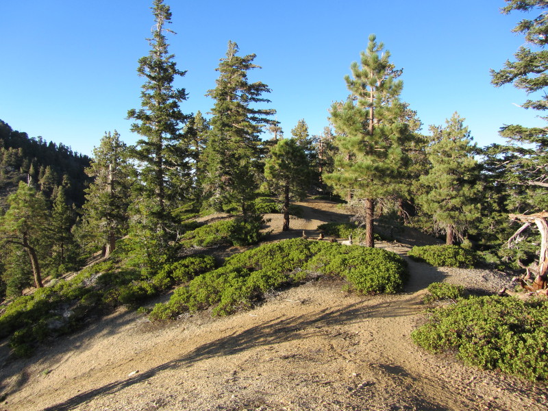
Back at the trail junction I turn right (northwest) to begin my 560-foot decent to a saddle. This is my first time on this portion of Three Tees Trail. Telegraph Peak looms ahead. I am thoroughly enjoying the incredible scenery. This truly is a wilderness with virtually no human trappings. The narrow path makes the lightest of impact. Carpets of manzanita cover the slopes and tall pines and firs reach to the sky.

View west from the approach to Timber/Telegraph saddle9:26 - Timber/Telegraph saddle (7740’). Amazing beauty! Windy. Views east and west. I review the map and psych up for the 1,245-foot climb ahead of me. Still can’t see any semblance of trial up the steep ridge. I continue up the trail as it climbs northwest past knob 8023’. The manzanita needs trimming along the trail here. Great view down into Telegraph Wash. I reach another small saddle and decide to walk the 100 yards or so south to the top of knob 8023’. Most rewarding. Back at the saddle I hear voices coming up the trail.

View north up the ridge on the south side of Telegraph RidgeAt 10:16 I begin to climb the steep ridge to Telegraph Peak. This route had been a mystery to me, but now I see, contrary to the maps, it does not go straight up the ridge. The trail climbs at a reasonable rate using a number of switchbacks as it zigzags up the east flank of the ridge. At several places the switchbacks meet the ridge and provide spectacular views west and down. At one of these points I scramble off trail 30 feet to a rugged outcropping and linger for a bit, enjoy great views, and let the noisy voices of two male hikers pass. I continue up. I’m so enjoying the amazing landscape and thankful for the cool weather.

The trail reaches a wide hip on the ridge below high point 8921’. I pause to soak in the views. A passerby asks for directions. Others are coming up the trail. I run into Andrew with SGV Hikers. He is leading a group of about 20. I met Andrew at Fish Canyon a while back. From here the trail climbs straightway to the gentle saddle between Telegraph Peak and high point 8921’. Just before reaching that saddle, I turn left and take the 5-minute walk to the high point, which stands at the southern edge of Telegraph Ridge.

View southwest from summit 892111:24 - Summit 8921’. Wow! For an unnamed summit that is mostly ignored, this is one the finest peaks in the San Gabriels! The scenery is stunning. I sit on a comfortable rock out of the cold wind, have some lunch, study the maps, and soak in the incredible landscape. There are remarkable places of solitude in the San Gabriels. Nearby thunder prompts me to move my poncho from my pack to my pants pocket. As I leave the summit I decide to explore the dominate ridge that juts west. As usual, it is a most rewarding jaunt. Now off to Telegraph Peak.

12:26 - Telegraph Peak junction (8800’). I’m back at the point where I was with my buddy Drew 8 years ago. Boy, has it been that long?! The scene is familiar because I have a photo of it on my Inspiration page. As I’m walking up the trial to Telegraph I run into Andrew again and with him is Letty, who I met at Fish Canyon awhile back. Nice to see her and meet Jennifer, who is a fan of Dan’s Hiking Pages. The trail gets steep in the final pitch to the summit. The sun is warm now and I’m ready to shed the long sleeves.

View east atop Telegraph Peak12:47 - Telegraph Peak 
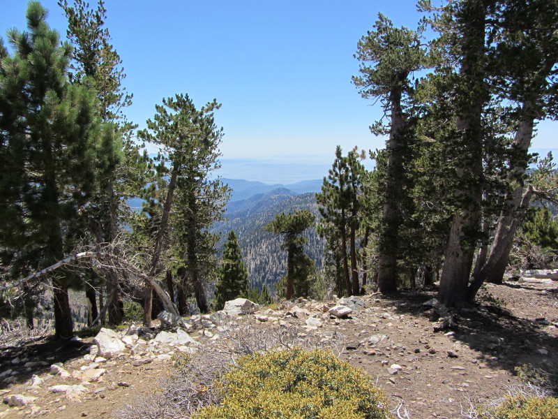
(8985’), the second of my Three Tees for today and 4,000 feet above the trailhead. This is wonderful peak with slopes steeply dropping a thousand feet. Three young men are leaving. The peak register is in stainless steal strongbox chained to a rock. Peaks in view include Timber, Bighorn, and Cucamonga to the south and Thunder, Dawson, Harwood, Badly, and West Baldy to the north. The Cajon Pass, the Mojave Desert, and the San Bernardino Mountains are to the east. Distant views are obscured by clouds and haze. The view west is dominated by the west end of the ridge where I was earlier (8921'). The clouds create fascinating shadows and lighting on the surrounding mountains.

Approching the Telegraph/Thunder SaddleLeave Telegraph peak at 1:20 and retrace my steps to the junction (9 minutes). Turn right (north) and begin the 620-foot descent to the Telegraph/Thunder saddle. Several long switchback legs negotiate the steep slope. I’m loving the majestic scenery of Cucamonga Wilderness.

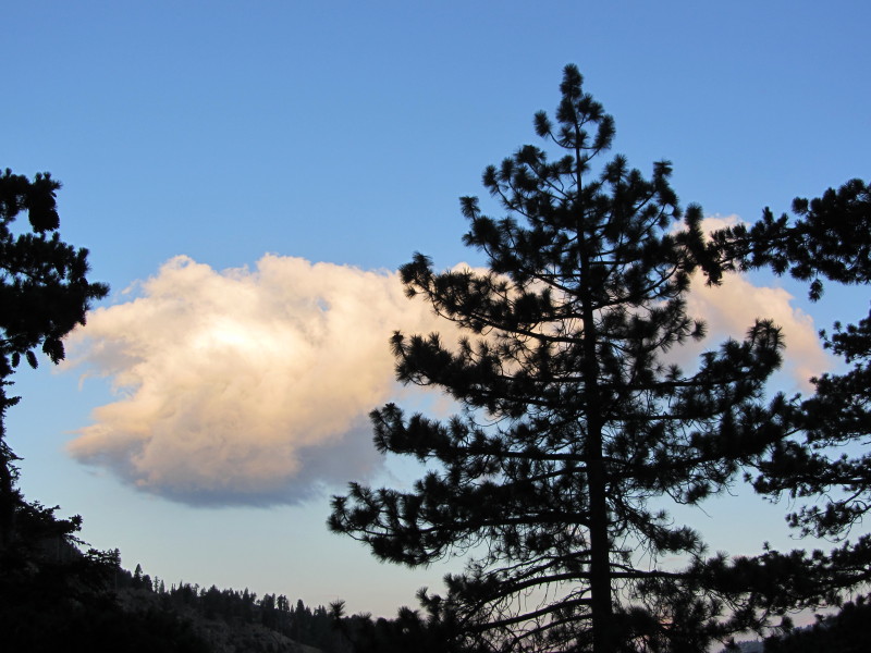
2:02 - Telegraph/Thunder saddle (8180’). Windy. Stunning imagery looking back toward the “Baldy-Bowl-like” northern slope of Telegraph Peak (photo at top). A lush carpet of manzanita graces the view down into Cedar Canyon to the west. I begin my final 400 feet of climbing for the day as the trail ascends the southern slope of Thunder Mt. At 2:22 I reach the end of Three Tees Trail at the wilderness boundary on the west ridge of Thunder Mt. I bend right on the wide ski-slope swath and walk the final 0.1 mile to the summit.

View north from Thunder Mt.2:33 - Thunder Mt. (8587’), the third of my Three Tees for today and the culmination of 5,100 feet in elevation gain. The bulldozed summit, ski lift machinery, fences, and other miscellaneous junk makes this peak a homely visit and an anticlimactic final peak to an otherwise fantastic hike. I make the best of it as I sit on the ski lift foundation, enjoy a snack, and reflect on the accomplishment of getting here. The billowing white clouds adorn the sky. Leave summit at 2:55. At the junction I turn right (east) and begin the 1.5-mile descent to Badly Notch. I ponder the possibility of building a handsome trail from the notch to bypass this unappealing dirt road. Almost to the notch, a 4-way signed junction, “Desert View,” provides a glimpse of the desert through the V-shaped canyon to the northeast, but it's nothing compared to the real desert views found on the peaks.

View back toward Baldy Notch Lodge from the chair lift3:42 - Baldy Notch (7840’). I’m done, kind of. Wander around a little more and take navigational notes for hike descriptions. I walk over to the chair lift on the far south and study the north slopes of Thunder Mt. looking for ways to bypass the dirt road. At the lodge I pay my $10 fare for the 15-minute ski lift ride down.

4:32 - Arrive at ski lift parking lot. Now to find a ride. Thankfully, the first people I asked were graciously willing to give me a ride to Icehouse. They are hikers new to the area and were scouting out trails. I arrive back to my car at 4:48.

Epilog - What a fulfilling day of hiking! The spectacular beauty along Three Tees Trail revivals anything that Baldy has to offer. I enjoyed considerable solitude and fascinating weather. Running into hikers I’ve met previously is always nice and I value the positive affirmation I receive from users of Dan’s Hiking Pages. Not being struck by lighting is a good thing. Encountering a bighorn sheep for the first time is an experience I shall savor. Ten miles and 5,100 feet in total elevation gain is good preparation for next week’s hike to Baldy via Bear Flat Trail. I am humbly ready to challenge The Mountain. icon

See Timber Mt. hike description and Telegraph Peak/Thunder Mt. hike description at Dan's Hiking Pages

CameraSee the photo album for this hike - Featuring 88 photos with captions
 

Bighorn Sheep! - September 10, 2011

Bighorn sheepNelson bighorn sheep find their home in the San Gabriel Mountains. They are magnificent creatures. For years I’ve heard lots of accounts of hikers sighting them, but I’ve never seen one. I’ve been hiking these mountains for years and putting myself in locations where they are known to frequent, but they always have eluded me.

Year after year, hike after hike, I go without seeing any bighorns. I’ve been on hikes and met other hikers who have seen bighorns that day. I was at the Bridge to Nowhere and missed a herd by about 3 minutes. It seems that every hiker I’ve talked with has seen bighorn sheep. So how come I never get to see one!?

I’ve seen bighorn scat and footprints. I’ve seen where they have bedded down. I’ve seen the holes they’ve dug. I’m always on the lookout for them. But for some reason I just never get to see any.

Bighorn SheepFinally, Saturday, September 10, 2011, after 16 years of hiking all over the San Gabriels, my bighorn sighting drought ended! On Three Ts Trail en route to Timber Mt., I finally came face to face with a splendid bighorn.

I got an early start at the Icehouse Canyon trailhead at 5:15 and had total solitude the whole way to Icehouse Saddle. I spent only 5 minutes there and headed north toward Timber Mt. On the second switchback as I was approaching the ridge, I looked up and there was a magnificent bighorn ram standing majestically on the ridge about 150 feet away. I gasped in unbelief. Thankfully I had my camera in hand and was able to get a shot off before he moved. I got a second shot as he began to leave. I shot some video as he climbed the slope and two more stills as he disappeared.

Bighorn footprintIt was a wonderful encounter! Over the years I’ve seen bear, deer, fox, bobcat, coyote, rattlesnake...but nothing compares to finally experiencing a bighorn sheep. I shall savor the experience. icon

icon View Three Tees Hike blog for the whole story of this hike

Animals See Animals of the San Gabriel Mountains at Dan's Hiking Pages

Visit Dan's Hiking Pages

Saturday, September 3, 2011

Throop, Burnham, Baden-Powell - Sept. 3, 2011

View west from Mt. Baden-PowellSee Mt. Baden-Powell hike report (5-31-04) at Dan's Hiking Pages

What an amazing day of hiking in the San Gabriels’ high country! This time I took the long drive up Angeles Crest Highway with my friend Mark to conquer a couple peaks that I have not had a chance to climb: Throop Peak (9138’) and Mt. Burnham (8997’). And while we were at it, we ended up adding Mt. Baden-Powell (9399’) to cap it off.

Mark and leave my house at about 5:45, head west on the 210 freeway toward La Canada and then north and east on the Angeles Crest Highway. Driving through the Station Fire burn area, I’m greatly saddened to see thousands of acres that were previously magnificent, mature forest, now laid waste. The horrific damage is beyond words.

We arrive at Dawson Saddle (7901’) at about 7:20. The air is brisk. Mark attempts to reach his friend Don who was to meet us here. I survey the trailhead area. We chat with a couple bow hunters. Don’s not coming so we’re ready to hike.

View south from Dawson Saddle Trail8:20 AM - Begin hike on Dawson Saddle Trail heading south up the ridge. After a few steep switchbacks I suspect that we are not on the right trial. My suspicions were confirmed in about 10 minutes as we reach a junction with the formal trail coming from the left. Soon the climb mellows as the trail ascends the gentle ridge. The mature forest and wonderful views are incredible. The trail was built by Boy Scouts in the summer of 1982 to commemorate the 75th year of world scouting at the cost of 3540 volunteer hours. I am falling in love with this wonderful trail and find it to be one of the finest in the San Gabriels.

View west toward Windy Gap and Mt. Islip from Dawson Saddle TrailI really enjoy hiking an ascending ridge like this because of the varying views. Throop Peek looms ahead to the south while Mt. Burnham and Mt. Baden-Powell dominate the ridge to southeast. Windy Gap and Mt. Islip stand nearby to the west while Mt. Wilson country is seen in the distance. To the north Mt. Lewis pokes up while the vast Mojave Desert consumes the horizon. On both sides of the ridge we see the Angeles Crest Highway below as it meanders through the high county. Occasionally we hear a car or motorcycle. After about 1.5 miles the trail bends east across the north face of Throop Peak. A couple ladies pass us.

9:35 - Junction with Pacific Crest Trail (1.8 miles). A sign greets us. A few more steps to the ridge and we look south down into Iron Fork of the San Gabriel River and the vast Sheep Mountain Wilderness. Beyond is Mt. Baldy, Ontario Ridge and the vast human sprawl obscured by a layer of haze. A slight breeze feels good. We hang out here for a while then turn right (west) and follow PCT. In about a minute we reach a “Y” and veer right to follow the use path to the summit.

On top Throop Peak10:14 - Throop Peak (9138’). Wow, what a splendid summit! I like it! The scarcity of trees affords great views in most directions. A bronze plaque honors Amos G. Throop, founder of Throop University (now known as Cal Tech). We hang out for a while. A lady arrives at the peak coming from the west. Her name is Debbie and we enjoy talking about hiking. The peak register, housed in a baggy under a small rock, is new and was placed here by Ken Rose. We are the first to sign it. A sailplane glides in the blue sky above. Mt Burnham to the east calls us to proceed.

View east toward Mt. Burnham and Mt. Baden-Powell11:05 - Leave Throop Peak and retrace our steps east. The sun is warm but the temperature is pleasant. At 11:15 we pass the trial junction for Dawson Saddle Trail and continue east descending on PCT. I’m loving the scenery and wonderful weather. In the distance we watch an LA County sheriff’s helicopter land at Dawson Saddle. Wonder what that’s about. The trail follows closely along the north side of the ridge and provides intermediate views south. As we get closer to the Throop/Burnham saddle, Mt. Burnham looks more imposing. Gnarled and twisted trees speak of harsh winters.

11:52 - Reach the junction west of Burnham (8710’). The Harrison map shows the main trail contouring to the left around the north face of the summit and a secondary trail bearing right and heading straight up the ridge. We choose to veer right and begin the steep ascent. The “trial” soon becomes indistinct but we keep climbing. Meet a young man named Kenny who is out pacing us.

View south from Mt. Burnham12:16 - Mt. Burnham (8997’). Nice peak. Views are somewhat obscured by trees. Chat with Kenny. A man and his 15-year-old son arrive with their little dog. We chat. Kenny leaves. Sign the peak registered, which has no protective home except a baggie. Mark and I decide that we have plenty of hike in us so we continue east to conquer Baden-Powell. Leave summit at 12:48.

12:53 - Reach junction with PCT on east side of Burnham (8900’). That route on the east flank of Burnham would definitely be the easier way to reach the top, but we don’t regret our adventure climb up the west side. Stop and chat with the two ladies we saw earlier. Soon the trail approaches a nameless bump on the ridge (9088’), ascends a switchback on the southern flank, and crosses over to the north side. We opt not to summit the bump as the trail skirts along the north. A prominent ridge descends gently to the north and I ponder cross-country routes. A group of six colorfully glad older hikers approaches from the east. We reach the ridge again and stop for a nutrition break with wonderful views south. Debbie arrives on her way down. We chat. Finish our break and continue and soon the trail traverses below the ridge on the north. I get excited as I see the trail on a spur ridge coming up from Vincent Gap.

View east2:11 - Mt. Baden-Powell PCT Junction. Wow, spectacular view down into Mine Gulch and the upper reaches of the East Fork San Gabriel River and beyond to Mt. Baldy! This is some of the most dramatic scenery in the range. The “Wally” Walden Tree, a 1,500 year old limber pine, stands majestically on the ridge. We turn right and head south up the trial and several switchbacks for the final 0.1 mile to the summit.

Atop Mt. Baden Powell2:22 - Mt. Baden-Powell (9399’). This peak stands as one of the truly grand summits of the San Gabriels. Years ago this bald peak was known as North Baldy. In 1931 the mountain was renamed in honor of Lord Baden-Powell, the founder of boy scouting.

There are about 15 people on the summit, including a group of 5 (Nick and family from Commerce), who we enjoyed visiting with. It’s a little warm but a gentle breeze feels great. I have cell reception to call my wife but can’t connect to the Internet to upload to Facebook. I soak in the spectacular views. The 360-dregee panorama includes the vast Mojave Desert to the North, the vast Pacific Ocean to the south, and the rugged San Gabriel Mountains in between. The human sprawl is muted by haze, giving an ethereal sense of being away from it all. I am delighted we made the choice to press onto this superb peak. I was here 7 years ago, but it is certainly worth visiting more often.


View west from Mt. Baden Powell toward
Troop Peak and Mt. Burnham


View south from Pacific Crest Trail3:31 - Leave Baden-Powell. Retrace our steps back. When we reach the east slope of the bump between Baden-Powell and Burnham, Mark continues down the trail and I decide to conquer this peaklet (9088’). Three minutes is all it takes to reach its summit. The west slope is steeper and rockier but soon I reconnect with Mark. When we reach the junction at the east side of Burnham we stay right and follow PCT around the north flank and reach the junction west of Burnham at 4:36. I enjoy taking pictures in completely different lighting than this morning. The trail is gentle here along the ridge but soon begins the ascent toward Throop Peak, our final climb of the day.

View south on Dawson Saddle Trail5:22 - Junction with Dawson Saddle Trail. Now just 1.8 miles of a pleasant downhill walk to go. I savor how enjoyable this hike has been. Part of me is somewhat tired from a long day of hiking, but part of me is sad to see such a splendid outing come to an end. As we get near Dawson Saddle we stay on the main trail (the portion we missed this morning) and observe that it is a much more desirable route than the old trail section we took this morning. It hits the highway about 250 yards east of the maintenance building.

Dawson Saddle6:20 - Done...exactly 10 hours from the start. I scout around the trailhead area to collect good notes for my hike description.

Epilog - What a thoroughly enjoyable hike on some of the finest trails and in some of the most incredible scenery the San Gabriel Mountains have to offer! The weather was absolutely perfect and the foot traffic was surprisingly thin for Labor Day weekend. Visiting two new peaks was a treat and climbing Baden-Power is always rewarding. I always value Mark’s companionship and glean from his years of hiking experience. And we had lots of nice conversations with other hikers along the way. Mark and I were probably the slowest hikers on the trial today, but no one enjoyed it more than we did. I’ve long touted the trail to Baden-Powell as my favorite in the San Gabriels, and now I can include the trails coming from the west. On the other hand, Mt. Baldy is a great summit, but I’ve always lamented that one can’t get there without hiking on dirt roads or scrambling up crazy steep use paths. The quintessential trails to Baden-Powell are a hiker’s delight. Today we covered 9.3 miles and climbed 2,530 in elevation gain...a most respectable outing. I am so thankful for the opportunity to hike. icon

See Mt. Baden-Powell hike report (5-31-04) at Dan's Hiking Pages

CameraSee the photo album for this hike - Featuring 88 photos with captions