
Two weeks after this hike, the Colby Fire incinerated the environs of these trails. Visit my
Garcia to Colby Farewell Tour photo album (12-31-13)
After a three-month hiatus from hiking, I needed to cap off the year with a hike. And my local Garcia Trial seemed ideal. In both 2012 and 2011 I hiked Garcia Trail on New Years Day, so this time I’ll end my year with it. My wife dropped me off at the trailhead five minutes from our house. There are a couple dozen people lingering around the trailhead. It’s a pleasant 66 degrees and forecasted to hit 73 today.
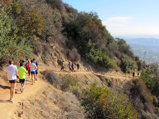
10:20 AM - Begin hike (3 to 4 hours later than I would normally begin a hike). I’m immediately struck by the amount of foot traffic...tons of people on the trail today...hundreds! I steadily climb through mature chaparral under sunny skies. Haze mutes the view of the human sprawl below. I run into Francis, a gentleman I met last year at a hike presentation at Azusa City Library. Enjoy chatting. I meet three gals who are picking up plastic bottles with a long extension grabber. Bless them for helping keep the trail clean. There is nothing in bloom except for a few occurrences of wild cucumber and its tiny white flowers. At 11:10 I reach the upper ridge and Glendora Ridge Motorway with views into San Gabriel Canyon and the expansive San Gabriel Mountains. I turn east to make the final climb to the summit.
11:17 - Azusa Peak (2081’). There are about 30 people and two dogs here with folks coming and going. Quite honestly, I can’t think of another peak in the San Gabriels that get so much traffic aside from Mt. Baldy and Echo Mountain. This is like a tourist attraction. No one is dressed like a hiker; lots of spandex, work-out cloths, and bright colors. The iconic cross seems to be the focal point of activity as various ones take turns posing for photos with it. To the east, Glendora Peak calls me higher and certainly will offer a reprieve from the crowds.

11:30 - Leave Azusa Peak and head east down the path and in a few minutes arrive at Glendora Ridge Motorway again. The walk along the wide dirt road is peaceful. The warm sun feels good. I’m always stuck by the visual dichotomy of this ridge: The southern panorama is dominated by vast human sprawl while the northern panorama features rugged mountains. A small white blossom of a cliff aster stands alone with virtually nothing else in bloom. But it is winter, and the red berries of toyon add a splash of color to the vegetation.
Over my shoulder to the west I get a view of the mountainside burned by the Madre Fire. The fire started on Sept. 23 and incinerated nearly 300 hundred acres at the month of San Gabriel Canyon. I had some tense hours as a spectator standing near the command center hoping they could contain the inferno quickly. Kudos to the firefighters and their gallant efforts in keeping the fire from consuming the mature chaparral that graces the rugged canyons and ridges above Azusa.

Madre Fire, Azusa – Sept. 24, 2013
|

View of Madre Fire burn area
|
Glendora Peak dominates the skyline in front of me. Soon I reach the off-road junction and I decide to veer right unto the narrow use path that climbs the west ridge. It’s a good choice as I enjoy expanding views and solitude (although, I encountered only three people since leaving Azusa Peak). The route gets quite steep as it approaches the summit.
12:10 - Glendora Peak (2596’). The broad, rounded summit offers some great views. From east to north, the grand high country, crowned by Mt. Baldy, defines the horizon. Typically those lofty summits are covered with snow this time of year, but not today. I see many peaks fostering memories of splendid hikes. Have a bite to eat.
Leave the summit at 12:35 and head east. Within a few minutes I’m back on the dirt road and continue east. I’m loving the scenery and ever-changing views along this rollercoaster route. Soon the Colby Trail area comes into view way down at the base of the mountain to the east.

At a point where the road bends north, I scamper up to a high point (2400+) overlooking Englewild Canyon to the east. A gentle ridge descends south to the head of Harrow Canyon; the old topo map shows a firebreak on the ridge. I consider descending this ridge but it looks pretty brushy with no clear path. Looking across the chasm to the east, I see a long, gentle ridge with a clear path. This will be my route down. Looking back at the road, I see a guy walking with an umbrella…not a typical sight here. I head back down to the road and continue north and northeast. I consider climbing the west ridge to summit 2583’ but decide to skirt it to the north along the road. At 3.08 miles from Azusa Peak, I reach the junction to water tank TW8. I turn right (south) and climb 0.14 mile and 125 vertical feet to achieve the summit.

2:01 - Summit 2583’. A concrete foundation is all that is left of what the topo map shows as a radio facility. Sections of Glendora Mountain Road (GMR) can be seen just down the hillside. Now for the fun part! The route, known as Upper Colby Trail, descends south down the ridge 1.1 miles to the upper terminus of Colby Trail at GMR. It’s popular with mountain bikers. I’ve not been on this upper trail before so this will be a chance to explore some new territory.

2:06 - I begin my descent. It starts gently but within a couple minutes I reach a crazy steep drop. Gosh, I’ve got to climb down this?! After a few moments of building up courage, I take the plunge. Crabbing on all five helps negotiate the most perilous sections. It takes me six minutes to get down safely. In a few more minutes I reach another steep section, but this one is not as bad. I continue down the ridge enjoying varying views and warm sunshine. An occasional vehicle on GMR breaks the tranquility. I come across some cougar tracks. Mountain bikers have spent a lot of energy building finely formed dirt jumps along the route.
3:10 - I finally reach a hairpin bend of GMR. The route continues south down the slope. It’s crazy steep with loose footing, dropping about 140 vertical feet in just 0.07 mile. As I’m climbing down a young man tries coaxing a young woman to climb up, but to no avail. I don’t blame her for opting out of this crazy route. It takes me nine minutes to make the descent and arrive at GMR again. I text my wife with my ETA and linger here for a few minutes.
3:30 - Begin my descent on Colby Trail. I’m now back on familiar ground. My pace is relaxed. Others are enjoying the trail. I always appreciate the good folks of
Glendora Community Conservancy for their efforts in maintaining this splendid trail and preserving natural space. I love the warm light of the “golden hour.” The golden leaves of western sycamore speak of changing seasons.
4:02 - Finish hike at the Colby Trail trailhead at the top of Loraine Avenue in Glendora. It’s 68 degrees.
Epilog - What a splendid outing in my local hills to end 2013! I covered 6.22 miles with great weather, rugged scenery, familiar trails and a new route, crowds and solitude, and good exercise. What a blessing to live at the base of the beautiful San Gabriel Mountains and being able to hike!

Two weeks after this hike, the Colby Fire incinerated the environs of these trails. Visit my
Garcia to Colby Farewell Tour photo album (12-31-13)
 See Trail Descriptions on Dan's Hiking Pages:
-
Garcia Trail to Azusa Peak
-
Colby Trail
NEXT > Colby Trail Tree Planting and Hike - March 8, 2014
PREVIOUS > Colby Trail, Amgen Bike Race & a Solar Eclipse - May 20, 2012


