The pointed summit of Mount Islip with its amazing 360-degree panorama over the heart of the San Gabriels is a great summertime hike. Mt. Islip is one of my favorite peaks and is always worthy of return visits. It’s been a while since I’ve climbed its lofty summit, and I’ve not done any high-country hiking yet this summer. So when I got the email from my friend Ray and his
Hikemasters hiking group announcing a Mt. Islip hike, I decided to jump in. The plan is to begin on Windy Gap Trail, take Big Cienega Trail to Islip Ridge and on to the summit, then return via Windy Gap Trail. It makes a splendid loop of 7.2 miles with 2,418 feet elevation gain.
I walk the five minutes from my home in Azusa to the corning of 9th Street and Hwy 39 where Ray conveniently picks me up at 6:30 a.m. We drive north to the rendezvous point near the mouth of San Gabriel Canyon. Soon others arrive and we caravan the 24 miles to the Crystal Lake Campground and Windy Gap Trail trailhead. The 27 of us gather for the customary group photo.
8:02 a.m. - Begin hike. It’s brisk and I’m the only one in short sleeves. Within five minutes, however, I’m quite comfortable. The aromas of campfires fill the air. Majestic pines, firs, and cedars tower into the deep blue sky. A luminescent glow on Hawkins Ridge high above announces the sun’s eminent appearance. Within five minutes the sun’s rays fall upon our surrounds. I began at the front of the pack but pausing for a few photographs puts me in the middle now.

I love the freshness of morning in the forest.
At 8:15 we cross the first occurrence of South Mt. Hawkins Fire Road (0.4 miles from the start). The forest thins out as we transition into area devastated by the
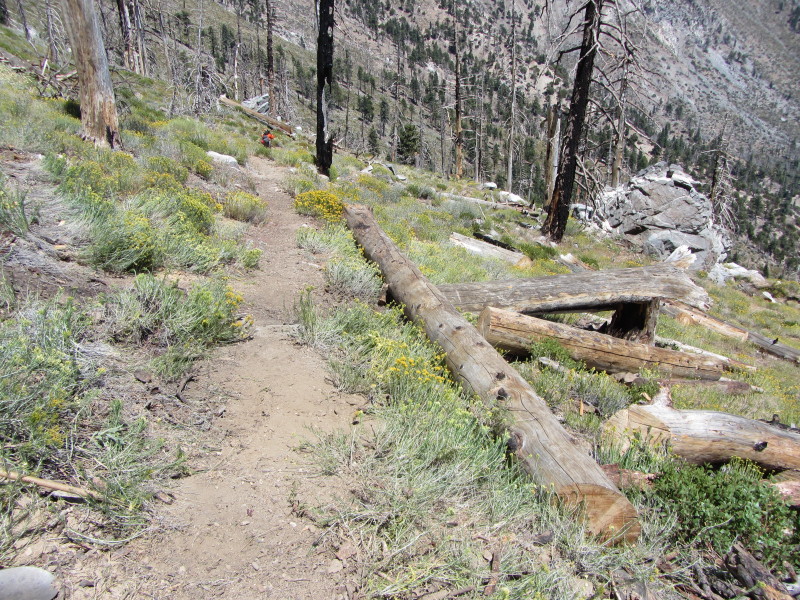
September 2002 Curve Fire. Mt. Islip and Windy Gap comes into view high to our north. I snap pictures of the blooms that subtly grace the path: California fuchsia, leafy daisy, rabbit brush, evening primrose, and yerba santa. As several in the group take an interest in plants, I am happy do some docenting along the way. The views begin to open up to the south toward inland valleys covered with a marine layer. Lifeless tree trunks jut into the sky creating strange and eerie art pieces.


8:50 - South Mt. Hawkins Fire Road, second occurrence (1.1 miles from the start). I walk over to the berm and point out to David a huge round (slice from a tree trunk) and tell him the exciting story of how it got there 12 years ago on a San Gabriel Mountains Trailbuilders’ work day (Hint: The fallen tree was 100 yards up the ravine and there were cars parked along this road). We continue up the trail and within a couple minutes turn left unto Big Cienega Trail. The sign indicates 1.8 miles to Islip Ridge. I snap pictures of California buckwheat,

Indian paintbrush, and Douglas nightshade in bloom. The scenery is grand. Soon we cross a stream rich with lush vegetation and blooming scarlet monkey flower, Bigelow's sneezeweed, and lemon lily. Further up the trail there are blossoms of lupine, milkweed, goldenrod, everlasting, and bush chinquapin. Huge cedars reach to the sky. Their thick bark is burnt and protected the tree from the ravaging fire.
As I soak in the beauty of the spectacular scenery, I find myself being flooded with happy emotions. I first started working on these trails 12 years ago with the
San Gabriel Mountains Trailbuilders. It was less than one year after the curve fire incinerated 21,000 acres of our national forest. The scenery then was barren moonscape and working here was depressing. Here is an excerpt from my hike report from the
Trailbuilders’ work day on August 30, 2003:
The devastation is particularly bad at the lower end of the Big Cienega Trail. Stark, blackened trees rise as toothpicks from the barren, rocky ground, which is void of any organic material. What groundcover the fire didn't consume was washed away by torrents of unrestrained water rushing down the slopes from heavy winter rain. As I graded trail tread and saw a fine footpath emerge, I couldn't help wonder who would even want to hike through this desolate moonscape, regardless of how pristine the path.
Today I feel happiness as I see the cycle of life take its course and scenery that speaks of natural beauty louder than the devastation of fire. I’m really enjoying the splendid landscape.
I begin to realize that Ed, who was appointed as the sweep, is no longer with us and I am hiking with three who are very slow, including one young lady on her first hike. We stop often as we plod our way up the mountainside. I point out our destination—Mt. Islip—high above us to the north, and they seem daunted by the challenge.

10:34 - Islip Ridge Junction (2.6 miles from the start). The sign indicates 0.9 miles to Mt. Islip. We turn right (north) and begin ascending the broad ridge. Soon views open up west into Bear Canyon and the rugged San Gabriel Wilderness dominated by Twin Peaks.

I’m loving the amazing scenery, great weather, blue skies, pleasant breezes, and fulfilling memories of previous hikes here. Across the yawning basin to the east, Hawkins Ridge stands as a vivid reminder my most awesome adventure
commemorating the 10-year anniversary of the Curve Fire.
Up we continue to climb. Soon Hwy. 2 and Mt. Williamson come into view to the northwest. Our path is subtle and nondescript in places. Cut tree trunks remind me of Trailbuilders’ work days. Far to the south, Saddleback pokes above the marine layer. The trail leaves the ridge and begins to traverse and zig zag up Islip’s south flank. Our pace is dreadfully slow and I wonder if the rest of the group will even be waiting for us at the summit.
11:49 - Mt. Islip Junction. To the right (east) is Little Jimmy Trail Camp (1.1) and Windy Gap. We turn left. The sign says 0.1 to Mt. Islip, which is incorrect; it is actually 0.2 mile. I’m eager to reach the summit but trudge along with the caboose group. The views are wonderful.

We round the hip at 12:00. They decide to sit and rest so I leave them and head eagerly to the top.
12:01 - Mt. Islip (8250’). Our group is still here and looks like a small army on the small summit.

When the group had arrived, Wei Wei found a ring box tucked into the rocks. When she opened it she found a ring and a note. The note reads:
This box contains promises unfulfilled. Love that could not keep away the sorrow. Happiness that could not stem the tide of pain. Take this if you will. I don’t want it anymore. With it I give all that it has seen. 8/8/15. [initials]
How sad.
I do my best to switch my attention from the broken relationship and begin to appreciate the fine summit.
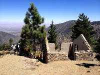
The 360-degree panorama is breathtaking. Marine layer still blankets the human sprawl to the south. I share with several standing by that the concrete footers were for the fire lookout tower which was built in 1927 and moved to South Hawkins in 1937. I point across the basin southeast to South Mt. Hawkins where the tower was burned to the ground on September 1, 2002 when the Curve Fire ravaged this forest.


I snap some pics and I try to soak in the beauty of this place as the group prepares to leave. I just got here! The group leaves at about 12:15 as I linger to capture a few more shots. The caboose group is still here too but Ed has stayed back to accompany them.
12:19 - I leave the summit with the caboose group, but I speed ahead. When I reach the hip I take a short-cut east straight down the ridge figuring I can catch the rest of the group, which I can see on the trail far below. I arrive at the trail in seven minutes and descend east on the fine path while enjoying a PB&J sandwich. Thankfully the Curve Fire was pretty much was stopped at this ridge and the mature coniferous forest (cone bearing) was spared and stands majestically on the northern slopes. My pace is earnest as I enjoy the rich forest and grand scenery. A group of six passes me on their way to the top.
The trail leaves the ridge and cuts north toward Little Jimmy. Ray is standing on the trail waiting to see how the caboose group is doing. I said they should be just a few minutes behind me and he said the rest of the group is waiting at Windy Gap. I continue down. The last time I was on this trail I was
climbing it with a chainsaw crew. I look across to the northeast and admire Mount Lewis (8396’) with fond memories of climbing it with the Hikemasters group along with two other peaks on
September 28, 2013.
12:52 - Windy Gap (7588’). It’s windy, of course. Our main group had decided to leave so just two gals are waiting. Other groups are here as well. Seems like there is always people here. Ray joins us and tells us to go ahead and he’s going back to check on the others. I empty the dirt from my boots (from the short-cut), we snap a few pics, and leave the gap at 1:00.
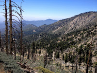
I love the magnificent scenery descending Windy Gap Trail. The Crystal Lake Basin spreads out before us.
The last time I was on this trail was returning from my surreal adventure through thick smoke on the
commemorating the 10-year anniversary of the Curve Fire. What an experience that was. Today is quite different and absolutely beautiful. I add to the blooming list golden yarrow, chicalote, and San Gabriel Mountains gilia (AKA volcanic gilia)—a tiny purple flower that’s easy to overlook.
It’s getting warm now. Others are heading up the trail and I wonder why folks begin a hike so late on a hot summer day. There are parts of the route that trail crews have really labored over battling the unstable debris slides. The wooden Sutter walls are no match for the huge rocks that tumble down the slopes left bare by the Curve Fire. (Be sure to thank trail volunteers if you happen to encounter them on one of their work days. Better yet, come out and help sometime. Everyone is welcome. The
San Gabriel Mountains Trailbuilders works on the first and third Saturdays of each month and are often here in the Crystal Lake Basin during the non-snowy seasons.)
Ray catches up with us at 1:24. He had returned all the way to the summit of Mt. Islip and did not find the caboose group. They must have returned the way they came rather than continuing on loop as planned. Ray is not happy. We continue down the trail at quick pace. Finally I just let them go figuring there will be a long wait at the trailhead for the caboose group. A family with two young girls is on their way to Little Jimmy for the night. It’s great to see parents introducing their kids to hiking and camping.
1:47 - Big Cienega Trail junction. Two minutes later I cross the upper occurrence of South Hawkins Fire Road. I think about the
black bear I came face to face with at this spot on July 23, 2011. That was an awesome experience. The sun is warm and the lighting is very different than when we came up this trail in the cool of the morning. I’m ready to be done. I cross the lower occurrence of the fire road at 2:11 and have 0.4 mile to go. I appreciate portions of shade from the oaks as I saunter down the rocky path into the campground.


2:25 - End hike. Ray and the two gals are here. Most of the others have left. Ray is going to wait for the caboose group so I thankfully catch a ride down with Cheryl and her niece (the group shot above is Cheryl’s). About half way down the mountain her brakes begin to have problems and we end up having to wait for AAA to come, summoned by helpful CHP officers. Ray stops on his way down and waits with us. Ed is with him but the caboose couple is still on the mountain someplace, having told Ed to go on ahead without them. Oh the drama of group hiking. The AAA truck finally arrives at 4:19 and I ride with Ray and Ed back to Azusa. BTW, this was my maiden hike with a new pair of Vasque boots and they performed superbly.
 Epilog
 - What an enjoyable hike! I love the Crystal Lake area with its amazing scenery, towering ridges and peaks, and splendid trails. Perfect weather, blue skies, fresh air, pleasant breezes, lofty trees, graceful wildflowers, good company, hearty exercise, and great memories. I am always so appreciative of the
Creator and the wherewithal to hike and enjoy his creation.

 See Hike Descriptions at Dan’s Hiking Pages
(Detailed trail guides include driving directions, recommended season, map, notes, links, and photos)
 Related links on Dan's Hiking Blog:


 I love the freshness of morning in the forest.


 Indian paintbrush, and Douglas nightshade in bloom. The scenery is grand. Soon we cross a stream rich with lush vegetation and blooming scarlet monkey flower, Bigelow's sneezeweed, and lemon lily. Further up the trail there are blossoms of lupine, milkweed, goldenrod, everlasting, and bush chinquapin. Huge cedars reach to the sky. Their thick bark is burnt and protected the tree from the ravaging fire.


 I’m loving the amazing scenery, great weather, blue skies, pleasant breezes, and fulfilling memories of previous hikes here. Across the yawning basin to the east, Hawkins Ridge stands as a vivid reminder my most awesome adventure commemorating the 10-year anniversary of the Curve Fire.

 We round the hip at 12:00. They decide to sit and rest so I leave them and head eagerly to the top.
 When the group had arrived, Wei Wei found a ring box tucked into the rocks. When she opened it she found a ring and a note. The note reads:

 The 360-degree panorama is breathtaking. Marine layer still blankets the human sprawl to the south. I share with several standing by that the concrete footers were for the fire lookout tower which was built in 1927 and moved to South Hawkins in 1937. I point across the basin southeast to South Mt. Hawkins where the tower was burned to the ground on September 1, 2002 when the Curve Fire ravaged this forest.


 The last time I was on this trail was returning from my surreal adventure through thick smoke on the commemorating the 10-year anniversary of the Curve Fire. What an experience that was. Today is quite different and absolutely beautiful. I add to the blooming list golden yarrow, chicalote, and San Gabriel Mountains gilia (AKA volcanic gilia)—a tiny purple flower that’s easy to overlook.


Photo Album - 120 images