The need for a conditioning hike occasioned this foray up the southern slopes of the Verdugo Mountains. My first adventure into the Verdugos was last December, and I so thoroughly enjoyed my hike, I knew I needed to come back. This small range, which lies between Crescenta Valley and Burbank, is best hiked in the winter or early spring when the rains have cleaned the air and brought green growth, flowers are blooming, and temps are pleasant. The time NOT to hike the Verdugos is in the middle of the summer on a hot day. I knew that, but I had to hike someplace nearby with substantial elevation gain, so this punishment was as good as any. And I’d cover some new territory to boot.

Along with my Verdugo Mountains Trail Map by Tom Harrison, I leaned on the ever-dependable Jerry Schad and decided that his South End Loop (5.5 miles, 1,500’ gain) would be the ideal core for this hike, with the option to add some additional mileage and elevation at the top. And approaching from the east should provide some shade and help mitigate the heat.
I leave my office in Echo Park at 3:10 p.m. and take Freeway 2 north to Glendale. I exit on Mountain and navigate my way to the trailhead at the intersection of Beaudry Blvd and Beaudry Terrance. It’s a brisk 96 degrees!
3:35 p.m. - Begin hike on Beaudry Motorway (1,200’). The paved route starts to the right of a flood control wash and in a couple minutes passes by a locked vehicle gate and proceeds up the canyon on a wide dirt road. It’s been freshly graded...looks like today. It’s hot but oaks and sycamores provide a good amount of shade. At 0.4 mile I reach the junction of Beaudry North and Beaudry South motorways. Schad suggests going right on the North route since it will provide more shade for the ascent.
I turn right on Beaudry North and follow the wide, dirt road that ascends the steep mountain slopes through rich chaparral. Shade from both the trees and the steep road cut provides sections of welcome relief from the intense sun. An occasional breeze feels good. Soon I am treated with expanding views of Crescenta Valley and the rugged San Gabriels rising steeply behind. As I climb higher I round a bend and get a good view toward Tongue Peak, my destination, high on the backbone ridge.

There is hardly anything in bloom. The weedy non-native grasses are brown, and some of the native chaparral plants, like sticky monkey flower and black sage look parched. Poison oak is beginning to turn its fall colors. A row of cypress trees along the road makes me wonder why man thinks he can improve on nature.
4:50 - Junction (2500’, 2.3 miles). To the left (south) is my return route, which will visit Tongua Peak and Mt. Thom, two of the three named peaks (along with Verdugo Peak) in the Verdugos. But I will go right for at least another 0.6 mile to a saddle which should afford me views west. I sit on a nice rock, have a snack, study the map, and upload a pic to Facebook. After a 20-minute break I head north. The road runs below the ridge on the east. I’m still enjoying great views toward Crescent Valley and the San Gabriels. Soon Verdugo Peak comes into view a mile and a half north.

5:30 - Junction / Saddle (2660’). Wow, this is nice! There are great views south and southwest. I can see all the way to the Channel Islands. A pair of wooden benches provide a comfortable place to sit. Brand Motorway arrives here from the southwest. I linger for a few minutes, enjoy the breeze, and capture the scene with my camera. A noteworthy summit rises to the immediate northwest, which looks like it might be a good highpoint to hit before turning back. A steep use path heads straight up the ridge to the pointed summit. But I suspect that there will be a milder route up the road at the next saddle. So I continue along the road.

5:47 - Saddle. More great views. This is the location where the abandoned Skyline Motorway arrives from the west. Indeed a gentle path leads to the fore-mention summit to the southeast. But to the northwest an even greater summit juts into the sky. A steep path climbs to the top. I can’t resist. Up I climb. It’s crazy steep with slippery footing. I stop often to catch my breath. My primary worry is climbing back down this way. It will be treacherous! I’m hoping the top will yield a safer route down. Ten minutes delivers to the backbone ridge. Wow, the great view is worth the climb! The highpoint is still 100 yards north, so I continue up.
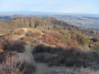
 View southeast toward whence I came View southeast toward whence I came
|
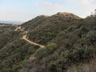
View south toward Tongua Peak and Mt. Thom
|
6:05 - Summit 2960’+. Now this is the sweat spot...360 degree panorama! It’s the highest point along the backbone until the cluster of summits around Verdugo Peak (3,126’), 0.75 mile north. I cast my eyes toward familiar landmarks amidst the vast human sprawl below me. I can see my office in Echo Park to the south. I’d like to linger here but it’s late. Not wanting to return on the treacherous route, I decide to continue along the ridge north. It appears that there is a doable route to meet the road in about 0.3 mile. Leave north at 6:17.
The ridge route is quite decent aside from some pesky brush on my bare legs. I descend to a saddle and up a steep path to another knob. Now it’s downhill the rest of the way. Just before another rise, I veer right on an old firebreak and follow a ridge northeast toward the road. The brush is thicker and I’m getting debris in my boots and on my sweaty clothes and skin. There’s not much foot traffic here and I’m concerned that this route will dead end at a steep road cut with no easy way down. Thankfully, a couple hairpins at the bottom of the ridge deliver me to the road at 6:43.
Now a nice dirt road the rest of the way! Soon a mountain biker passes…my first human encounter for the whole hike! I reach the saddle/junction with the abandoned Skyline Motorway and chuckle at my adventure up that steep route to Summit 2960+. Now I take the use path east to the summit I skipped earlier. Three minutes gets me to the top (2800+). I continue down the use path to the saddle.

7:06 - Junction / Saddle (2660’) (with Brand Motorway). To the south, Tongua Peak, basks orange in the nearly setting sun. I was hoping to get a good view of the sunset (7:24) but my summits to the west block line of sight. I’ll see if I can reach Tongue Peak in time. But first I sit on the bench and clean the debris from my boots. Two mountain bikers arrive. The setting sun colorfully illuminates the sky and clouds. An orange glow rests on the San Gabriels. I leave the junction at 7:14 and climb the use path veering east and in a minute I arrive at a round reservoir covered with corrugated steel. I ponder continuing down the ridge but it’s getting late and I’ve had enough wandering through brush today. I return to the junction and continue down the road. There is a beauty to dusk. More mountain bikers pass.
7:29 - Junction (2500’). I briefly ponder heading down the way I came up, but I haven’t come all this way to not bag the two named peaks at the south end of this range. Just past the junction a view opens to the west to reveal a gorgeous orange sky and the San Fernando Valley beginning to twinkle with lights. The route bends left (east) and winds its way to the summit. A large group of hikers are coming down.
7:37 - Tongua Peak (2656’). A barbed-wire topped chain-link fence surrounds a large communication array on the peak’s flattened top. I continue down the road with my eyes on Mt. Thom, about 0.7 mile away. It’s nearly dark now.
7:54 - Junction (2420’). To the right is Las Flores Motorway heading 2.4 miles south to Sunshine Drive. To the left is Beaudry Motorway South, my return route. Straight ahead is Mt. Thom. Several hikers are here and several more are coming down from Mt. Thom. I continue straight.
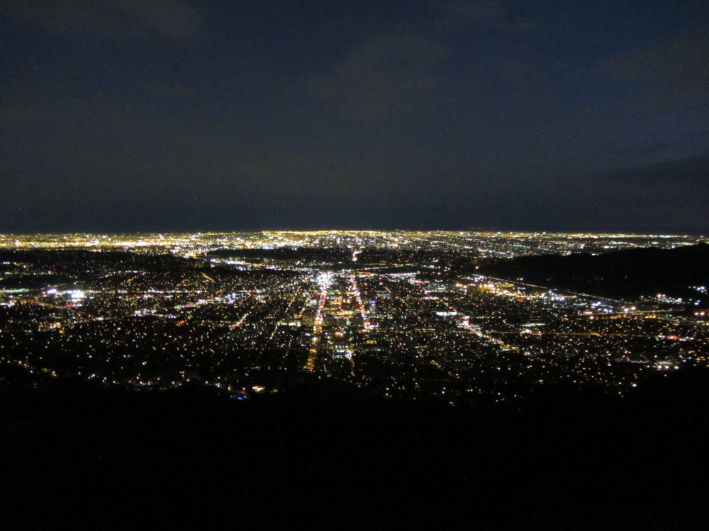
7:57 - Mt. Thom (2440’+). The flattened summit hosts another communication array. I circumnavigate the fenced facilities enjoying nighttime views over the immense human sprawl. I leave the summit at about 8:03 and return to the junction. I move my flashlight from my pack to my pocket. I turn right and start my 2.3-mile descent. The ambient city light reflecting off the clouds is sufficient for my walk. I’m tired and ready to be home. I stop and fix my left boot which is beginning to hurt my foot. It’s still quite warm. I’m enjoying the views. Hiking at night is very different. My pace is slow. The road is really steep in sections. I finally reach the last junction at 9:13, turn right, and retrace my steps to the trailhead.
9:26 p.m. - End hike. It’s 84 degrees!
Epilog - What a fun adventure which exceeded my expectations! I hiked 8.4 miles with 2,230 in elevation gain. I conquered two of the three named peak of the Verdugos and the 2960-plus-foot summit that towers over the south end of the range. I survived the heat. I enjoyed lots of solitude, good exercise, expansive views on a relatively clear day, and the beauty of day turning to night. I look forward to my next expedition into the Verdugo Mountains.
 Trail Notes:
Books: Jerry Schad
Trail Notes:
Books: Jerry Schad presents three hikes in the Verdugos. His “South End Loop” describes hiking up Beaudry North and returning on Beaudry South, 5.5 miles with 1,500 feet in elevation gain (which is the core of the hike I describe above; I added another 2.9 miles on the top).
John McKinney presents five hikes in the Verdugos; he briefly covers the same hike as Schad does as an option in his Beaudry Canyon hike.
Peaks: Both Tongua Peak and Mt. Thom are labeled on the Tom Harrison Map but with no elevations. Neither Tongua Peak nor Mt. Thom are labeled on the USGS topo map, (but Tongua is listed as 2656’), nor are they listed with the
USGS Board on Geographical Names. Both peaks are listed on Peckbagger.com:
Tongva Peak (2656’) (note spelling “Tongva” rather than ”Tongua”) |
Mount Thom (2440+’).
See my blog for Verdugo Peak Hike – Dec. 20, 2012
Visit Dan's Hiking Pages


 View southeast toward whence I came