
On Thursday, August 5, I had my monthly early morning meeting at work in L.A., so that gave me the chance for a late afternoon hike in Griffith Park. And with the long daylight days of summer and the unseasonably moderate temperatures, I can hit the trail hard. My mind easily crafted the hike to do—A big loop hitting all 6 named summits in the central core of the park: Bee Rock, Mt. Chapel, Mt. Bell, Mt. Hollywood, Glendale Peak, and Beacon Hill. And just to sweeten the pot, I'd also hit the prominent summits that don't have names but should: "Baby Bell" (aka Taco Peak) and "Hogback Peak." Sounds like a winner!
 3:40 p.m. - Begin at Old Zoo parking lot, head west, and soon I'm on Bee Rock Trail. The starting temp is only 81 degrees, so I move at a good pace.
4:04 - Bee Rock (1056'). It's warmer than the last time I was here in April, but the strong breeze cools me down. I spend only 4 minutes here and head west on Vista Del Valle Drive and arrive at Mt. Hollywood Drive at 4:33. Veer left and in 50 yards reach the trail junction for Mt. Chapel. I hiked to Mt. Chapel in July 2009, but I summited it from the west. My choice now is climb the east route or climb the north route via the water tank. I choose the latter and it turns out to be a good choice.
 4:52 - Mt. Chapel (1614'). Nice vistas but the residual haze from this morning's "June gloom" obscures the panorama beyond the surrounding hills. I'm intrigued by "Simpson" rock.
 5:34 - Mt. Bell (1582')—forth time this year. It's breezy and cool. Have quick snack and begin descending the path east at 5:40. It takes 6 minutes to reach the saddle. I continue east to climb the west ridge of what I call "Baby Bell."
5:50 - "Baby Bell" (1560'+) (aka Taco Peak...the unnamed summit east of Mt. Bell). Can see all the summits of my trip except for Glendale Peak. Got to keep going, so 3 minutes is all this peak gets. Descend south and veer left to catch the trail coming around the peak. Meet Joey and give directions. Couple more minutes and I'm at the main trail coming up from Vista Del Valle Drive. Continue south along the ridge divide toward Mt. Hollywood with views east and west. Chat with gal who I gave directions to at the water tank on Mt. Chapel. I arrive at the major junction on the backside of Mt. Hollywood at 6:08 and keep pressing on.
 6:13 - Mt. Hollywood (1625'), peak 5 of 8 for the day. Lots of people as usual. So much to photograph. Hard not to linger, but keep the visit to 9 minutes. Retrace my steps to the junction. I turn right and descend the 3 minutes to Dante's View. Drink from the fountain, not because I don't have plenty of water in my CamelBak, but because it's there. Sun getting low in the sky. Start my descent on Hogback ridge. Climb the west ridge of the prominent unnamed summit.
 6:40 - "Hogback Peak" (1480'+). This substantial summit certainly is worthy of name. I don't like rushing through a hike, but I've covered all this territory before on one hike or another, so I don't feel too badly about moving quickly. Continue down Hogback. Confront two different dog owners for not using leashes. Really bugs me that these people think they are an exception to the law (LAMC.63.44-B.2.C). Cross the bridge and arrive at Henry's Trail at 6:58. Confront another inconsiderate dog owner. Ascend Henry's Trail.
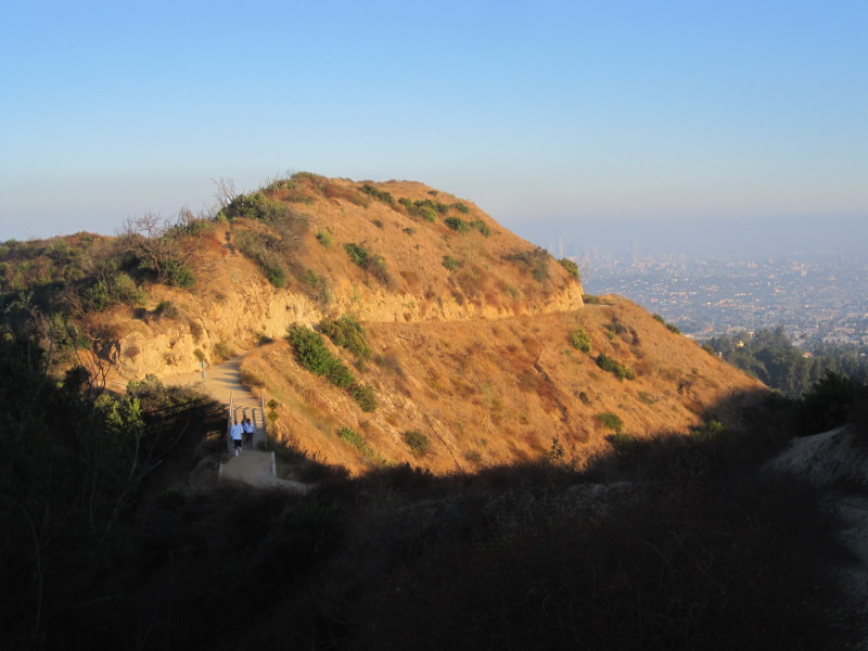 7:03 - Glendale Peak (1184'). This is so fun, hitting peak after peak racing against the setting sun. On my last visit here I noticed the path that descends east toward Vista Del Valle Drive. Looks like a great shortcut. I decide to take it. Snap picture of a yucca bloom and realize that this is the first plant I've photographed the entire hike! In 4 minutes I reach Vista Del Valle, almost. The path dead-ends at a shear rock face created by the road cut—a drop-off of about 15 feet! Oh no!! There is no way I can safely scale down without a rope, so I disappointedly turn around and climb back to Glendale Peak (Do I get credit for hitting it twice?!). That "shortcut" costs me only 11 minutes, but it seems a lot longer with tired feet and waning daylight. The sun is dipping behind Mt. Hollywood. Leave Glendale Peak a second time at 7:19 heading northwest back along Henry's Trail, turn left at the bridge, and reach Vista Del Valle Drive at 7:31. I snap pics of the rocky face and ponder my ill-fated shortcut attempt.
As I walk east on the eucalyptus-lined paved road, my pace is relaxed. My camera battery expires as I reach Joe Klass Water Spot. Sit at a picnic table and change my battery. Large group of Sierra Club hikers there. Continue northeast on dirt road and arrive at Five-Points junction at 7:50 and encounter another large group of hikers. Onward east to my last peak.
 7:56 - Beacon Hill (1001'), my eighth and final peak! The beauty of twilight and the twinkling lights of urban sprawl eludes adequate capture by my camera. Two other hikers arrive immediately after me, spoiling the hope of a few moments of solitude. Then a horde of Sierra Club hikers invades the summit. To turn a John Muir quote, "The mountains are calling and I must go."—I say, "Sierra Clubbers are swarming and I must go." Leave the summit at 8:10.
 I walk down Fern Canyon Trail in the dark. The ambient light from the city is sufficient for my steps. The cool air feels more like spring than summer. I savor the special atmosphere of nighttime in the park and the pleasure of such a rewarding hike. I reach Fern Canyon Trail trailhead at 8:40. Walk north past the large parking lots, cut through Old Zoo Picnic Area, and arrive at the car at 8:50.
Epilog - I'm so used to taking the time to soak in the beauty of my surroundings; this blitz-pace hike was atypical for me. But what a thoroughly fun and adventuresome outing! Great weather, lots of variety, good exercise, and the crafting of what I'll call my signature hike for Griffith Park.
(includes links to my other blog posts for hiking in Griffith Park, and links to detailed trail guides for the various components of this six peaks hike)
NEXT > Mt. Hollywood and Mt. Bell - October 10, 2010 (via observatory)
PREVIOUS > Mt. Bell via North Trail - July 8, 2010 (and Amir's Garden)
I will go to enjoy the getaways from los angeles for families. During this tour and I have a plan to explore Griffith Park. I am so excited about it.
ReplyDelete