Showing posts with label Bee Rock. Show all posts

Thursday, March 13, 2014

Old Zoo Park to Bee Rock and Mt. Bell - March 13, 2014

View west toward Bee Rock from Old Zoo Park
Griffith Icon It’s almost spring and a great time to hike in Griffith Park. Part of my job at work is to facilitate meetings, and this week we have meeting participants from all over the country in town. As the week unfolded it turned out that the meeting would end a half day early today. During weeks of previous meetings, I’ve had the pleasure of hosting Jeff (Kentucky) and Loren (Kansas) to hikes in Griffith Park. They were both up for a hike today and after mentioning it to Dave (Washington), he was in too.

So we pile into my car and head to Griffith Park. As we arrive at the Old Zoo parking lot, we found that the area is being used for filming a sitcom and the lot is closed off to cars. Thankfully there is a close-by parking place available.

Walking west through Old Zoo Park
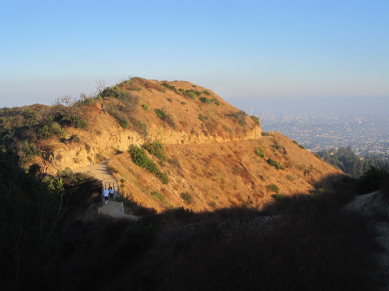
2:35 p.m. - We begin our hike by walking west along the closed-off parking area. The production crew is up ahead so I decide to bear left and take the guys through the old zoo. It’s a worthwhile side jaunt as we enjoy walking past the zoo enclosures which housed the small assortment of animals from 1912 to 1965. Up on the mountainside 600 vertical feet above us, Bee Rock stands as an imposing mass. The warm sun, pleasant temps, and gentle breeze provide perfect hiking weather. Stately sycamores are now in full leaf after their winter hiatus. We enjoy good conversation as we stroll along.

We pass through the pedestrian opening in the chain link fence and transition unto Bee Rock Trail, a wide dirt road climbing west. I point out some of the plants along the way. This is Dave’s first time hiking in Griffith Park and he is impressed by the rugged beauty and remote feel right in the heart of Los Angeles.

On Bee Rock Trail from Old Zoo Park
The heavy rains we had two weeks ago have brought a freshness to the plants. There is nothing in bloom yet except for a lone eupatory. Soon the wide road ends and our route cuts left turning into a narrow path. Now this feels like hiking. We enjoy the views opening up to sprawling Glendale and beyond. I point out some of the landmarks. The marine layer from this morning has left hazy skies. Lemonade berry joins my blooming list. High above us, a couple ladies stand atop bee rock. We’re having a great time. We reach the ridgeline and turn left (east) for our final steps.

View east toward Glendale from Bee Rock in Griffith Park
3:19 - Bee Rock (1056’). I’m always impressed with the amazing views from this protruding pinnacle, aside from the horrid, rusty chain link fence. The abundance of graffiti is a stark reminder of how blighted mankind is. A cool breeze feels good. We take some pics and enjoy the scenery. I point out Mt. Bell to our west, our next destination.

We leave the summit at 3:29. A four-minute walk along the fenced ridge brings us to the paved Vista Del Valle Drive. It still makes me sad that the early guardians of the park felt the need to carve up this beautiful island of natural space with wide roads. We veer right and saunter west on the paved road. Shortly we arrive at trail junction 16, one of the very few navigation posts left in the park. We turn left (south) and begin our climb up the steep dirt road. I point out the tender young leaves of poison oak as it emerges from its winter siesta. We enjoy the warm sun and expanding views.

Climbing a use path on the east flank of Mount Bell
At junction 39 (yes, another sign post!), we turn right for a short descent. Within a minute we notice a steep use path heading west up the slope toward the summit of Mt. Bell. It looks like the path gets a fair amount of foot traffic, suggesting that it may be a doable route to the top. From my observations from Mt. Bell on previous trips, I’ve noted that there is a network of paths heading in various directions. I toss out the idea of an adventure and the guys are eager to give it try. So up we climb. It is quite steep and is still damp from the recent rains, making it slippery. Soon we reach a junction and veer right. Shortly the trail vanishes and we’re left on the brushy mountainside. I’m always amazed that so much foot traffic goes nowhere! We retrace our steps to the previous junction and try the route that heads south. Shortly it splits. I have the guys wait while I veer right to see if it’s a good route. It looks good, but Loren yells over announcing he’s found a doable path. I figure his route will join the east approach to Bell from the Bell/Baby Bell saddle. So I yell across and give him my blessing (and hope he realizes he’s not in Kansas anymore). Dave follows him and Jeff follows me. Soon our route gets crazy steep, slippery, and brushy. Not a good choice! After a few minutes of thrashing we finally reach a decent trail (the route coming up from the northwest). That was an adventure! Another couple minutes delivers us to the summit.

View east from Mount Bell
4:21 - Mount Bell (1582’). Loren and Dave are sitting here waiting for us and give us a hard time for our poor route choice. But they both have wounds on their shins, so their route wasn’t a walk in the park either! I love this peak. The views aren’t great today because of the haze, but it still provides a most satisfying panorama. I point out various sights—the ocean, mountains, peaks, cities, studios, buildings, and so on. We are having a great time. The weather is wonderful. I’m always amazed by the solitude on this peak. As I look south across the canyon, there are at least a dozen people over on Mt. Hollywood.

We leave the peak at 4:53 and head down the southwest approach and six minutes get us to the dirt road. A lady passes by...only our second human encounter since leaving Zoo Park (we passed three gals on Bee Rock Trail)…surrounded by a metropolis of 13 million people, and we have this splendid hike virtually to ourselves! Go figure.

Heading northeast on Bill Eckert Trail in Griffith Park
We turn right (west) then another right at the saddle heading northeast. This is the route we would have been on if we hadn’t taken our “shortcut” up the mountainside. At the next junction we take a left and in five minutes arrive at Vista Del Valle Drive. We turn right and saunter along the paved road in the late afternoon shade enjoying good conversation. We pass junction 16 (where we turned earlier) and shortly reach the junction with Bill Eckert Trail (jct. 14). I decide to lead the group down this route to provide a loop with some different scenery. Soon we are enjoying the direct sun. I love the “golden hour” for photography. After a half-hour walk down Eckert Trail, we arrive at its lower terminus near Old Zoo Park. We turn right, then left, then pass through the chain link fence. They are still shooting the TV show as we walk by the production trucks along the paved road.

6:05 - End hike.

Dave, Loren, Jeff, and Dan on Mount Bell
Epilog – What an enjoyable outing! Great company, near-perfect weather, beautiful scenery, good exercise, splendid trails, two fun peaks, solitude, adventure. And topped off with dinner at In-N-Out! Life is good! icon

camera  View photo album for this hike

Griffith Icon  See Hiking Griffith Park at Dan's Hiking Pages
  (includes links to my other blog posts for hiking in Griffith Park)

Boot Icon See Bee Rock and Old Zoo Park hike description at Dan's Hiking Pages

Boot Icon See Brush Canyon to Mt. Bell hike description at Dan's Hiking Pages
(includes more detailed description for the approaches to Mt. Bell)

NEXT > Mt. Hollywood and Mt. Bell via Travel Town - April 9, 2015
PREVIOUS > Mt. Hollywood and Mt. Bell via Observatory - Sept. 19, 2013

Wednesday, November 21, 2012

Beacon, Glendale, Bee in Griffith Park - November 21, 2012

View east toward Bee Rock from Vista Del Valle Drive
Griffith Icon Very uncharacteristic for me, it’s been nearly seven weeks since I’ve been hiking. So I was eager to hit the trail, and a half day off work before Thanksgiving offered an ideal opportunity to hike in Griffith Park. For my many hikes in the park over the years, I’ve not repeated one yet. I’ve used many of the same trail sections, but combined them for different hikes. For today’s hike I tried out a use path to Beacon Hill, a use path to Glendale Peak (which I’ve been down but not up), a section of Vista Del Valle Drive (which I’ve not been on before), and descended Bee Rock Trail (which I’ve climbed but not descended).

I leave my office in Echo Park at 1:43 and navigate to the merry-go-round parking lot off Crystal Springs Drive on the east end of Griffith Park. I walk back to the parking lot entrance and walk across the street to the trailhead.

Lower Beacon Trail
2:15 PM – Begin hike on Lower Beacon Trail (#2) heading southeast. Within 3 minutes I reach an outward bend and am pleased to find my path heading up the ridge. I pre-scouted the route on Google maps aerial and it showed a clear, distinct trail. I turn right and begin to climb the narrow path up the broad ridge. The temperature is pleasant and the sunshine feels good. There’s a gentle breeze. Haze obscures the views today. The din of traffic on the I-5 provides an ever-present soundtrack. The route is somewhat steep but not bad. It feels good to be hiking. The yellowing leaves of black walnut add a splash of fall color. Soon Bee Rock to the northwest comes into view over my shoulder. As the trail mellows out, Beacon Hill comes into view up ahead. The 2007 fire incinerated this area, but vegetation is coming back well. It seems like the climb went quickly as I reach Upper Beacon Trail in 20 minutes. I turn left (east) on the dirt road and make the final steep climb to the summit.

View north from Beacon Hill, Griffith Park
2:35 - Beacon Hill (1001’). This isn’t a grand summit, but it stands as the eastern most point of the 40-mile-long Santa Monica Mountains. Glendale spreads out below me. The San Gabriel Mountains, dominating the skyline from the North to East, are virtually invisible today, as is downtown L.A. to the south. A man arrives and keeps going. I’m bummed that my camera lens cover is not retracting all the way.

I leave the summit at 2:55 and head west along the eucalyptus-lined road. Six minutes delivers me to 5-Points junction. I continue straight on the middle fork. There is nothing in bloom. Winter grass begins to push its way through the soil dampened by recent rain. A young couple passes walking some dogs. I pass below a water tank, round the bend to the south, and arrive at Vista View Point and the paved Vista Del Valle Drive.

View north toward Glendale Peak and the 4-point junction
I turn right (north) on the paved road and in about 100 yards reach a 4-point junction at 3:16. Folks are coming up Riverside Trail from the west. The grand observatory sits as a hazy silhouette to the west. I turn left, pass the green shed, and head west on Hogback Trail, signed “Bridle Trail.” In a few minutes I reach an outward bend and my short-cut route. I’ve been down this way but not up. I turn north and am thankful for long legs as I negotiate several big steps cut out of the steep granite to begin the climb. The use path is steep and the footing is comfortable in the soft dirt until near the top where the footing gets dicey on the exposed rock.

View south from Glendale Peak toward downtown L.A.
3:25 - Glendale Peak (1184’). The breeze is cool and the views are obliterated with haze. Ant-like humans dot the summit of Mt. Hollywood to the west. I post a picture to Facebook. It’s peaceful here. I consider heading north on Henry’s Trail to the bridge and seeing if there is a route down to the road. But I don’t have enough daylight to be taking chances on possible alternate routes.

I leave the summit at 3:40 heading down the same path. It’s a little more precarious descending. Back at the road I retrace my steps to the 4-point junction. There’s a fair amount of foot traffic here. For several years following the 2007 fire, this portion of Vista Del Valle Drive had been closed due to fire damage, thus I’ve not yet hike it.

View of Hogback bridge from Vista Del Valle Drive
I turn north on the paved road. I’m in total shade now and it’s cool. My pace is brisk. Shortly I arrive at the ravine with the footbridge above and discover that there is indeed and well-beaten route down the steep slope from the south end of the bridge. I can’t resist trying it out, so up I climb. It’s a little precarious and not for the faint of heart, but careful steps deliver me to the beginning of Henry’s Trail and the bridge. Three walkers pass. I take a few pictures and climb back down to the road. The side trip took 10 minutes.

View north on Vista Del Valle Drive
I continue north as the road gently ascends contouring along the mountainside. The sun still rests on Beacon Hill to the east. I can see the merry-go-round parking lot below. As I round a bend at the power tower, “Baby Bell” comes into view to the northwest with the sun still resting on it. The sun sets in about 35 minutes so I press the pace. Across Spring Canyon, tiny figures stand on Bee Rock. I’m enjoying the views of the various features at east of the park from a different perspective, but I wish I had better lighting. After what seemed like a long walk, I finally reach the bend and transition unto the trail descending east along the ridge for a 3-minute walk to the rock.

View east from Bee Rock, Griffith Park
4:33 - Bee Rock (1056’). The mountain casts shade on the west portion of Glendale while dim rays of sun rest on highpoints on the east side. The San Gabriels are but a faint outline through the thick, orange haze. It’s breezy and quite cool now. I briefly take in the views, snap a few pics, put on a long-sleeved shirt, and leave at 4:37.

It’s only 10 minutes till sunset but I know I’ll have plenty of light to navigate the narrow trail down. This is the first time I’ve descended Bee Rock Trail. My other visits to Bee Rock were the first stage of loop hikes that took other routes down. My camera doesn’t really capture the beauty of dusk. The yellow leaves of black walnut almost glow. My pace is relaxed now. It takes me 15 minutes to the dirt road where I turn east. In a few minutes I reach the junction of Old Zoo Trail.

En route from Old Zoo Park to Merry-go-round Parking lot
I pass through the fence and saunter through Old Zoo Park. Western sycamores display beautiful fall colors but the lighting is too dim now to capture it. A family strolls across the grass with their dogs. Some young men are exploring old animal cages. The walk is peaceful as I head southeast to complete the loop. Glendale is now a blanket of twinkling lights seen through the trees. I have happy memories of other hikes in Griffith Park that ended in nightfall.

5:15 - End Hike.

California black walnut at dusk, Bee Rock Trail
Epilog - A very pleasant outing. I love Griffith Park and enjoy exploring new routes and experiencing the nuances of this wonderful place. I am pleased and somewhat surprised that all the dog walkers I encountered today were using leashes…that may be a first for me! I look forward to the green of spring when the flowers begin to add color to the hillside and the daylight lingers. icon

Griffith Icon  See Hiking Griffith Park at Dan's Hiking Pages
  (includes links to my other blog posts for hiking in Griffith Park)

Boot Icon See hike descriptions on Dan’s Hiking Pages
(Detailed trail guide including driving directions, recommended season, map, notes, links, and photos)
NEXT > Mt. Hollywood and Mt. Bell - April 12, 2013 (via Brush Canyon)
PREVIOUS > Griffith Observatory Space Shuttle Hike - Sept. 21, 2012

Thursday, August 5, 2010

Griffith Park Six Peaks Hike - August 5, 2010

Bee ♦ Chapel ♦ Bell ♦ Hollywood ♦ Glendale ♦ Beacon

View south from Mt. Hollywood toward Griffith ObservatoryGriffith Icon2010 has become the year of hiking Griffith Park for me. In April I began to seriously attack the trails and peaks of our beloved park, and by July, I had felt very satisfied with having completed all the main trail systems in the park. I began to ponder hikes that would hit multiple peaks in a single outing.

On Thursday, August 5, I had my monthly early morning meeting at work in L.A., so that gave me the chance for a late afternoon hike in Griffith Park. And with the long daylight days of summer and the unseasonably moderate temperatures, I can hit the trail hard. My mind easily crafted the hike to do—A big loop hitting all 6 named summits in the central core of the park: Bee Rock, Mt. Chapel, Mt. Bell, Mt. Hollywood, Glendale Peak, and Beacon Hill. And just to sweeten the pot, I'd also hit the prominent summits that don't have names but should: "Baby Bell" (aka Taco Peak) and "Hogback Peak." Sounds like a winner!
View east from Bee Rock3:40 p.m. - Begin at Old Zoo parking lot, head west, and soon I'm on Bee Rock Trail. The starting temp is only 81 degrees, so I move at a good pace.

4:04 - Bee Rock (1056'). It's warmer than the last time I was here in April, but the strong breeze cools me down. I spend only 4 minutes here and head west on Vista Del Valle Drive and arrive at Mt. Hollywood Drive at 4:33. Veer left and in 50 yards reach the trail junction for Mt. Chapel. I hiked to Mt. Chapel in July 2009, but I summited it from the west. My choice now is climb the east route or climb the north route via the water tank. I choose the latter and it turns out to be a good choice.

View east from Mt. Chapel toward Mt. Bell, Baby Bell, and Mt. Hollywood4:52 - Mt. Chapel (1614'). Nice vistas but the residual haze from this morning's "June gloom" obscures the panorama beyond the surrounding hills. I'm intrigued by "Simpson" rock. Simpson Rock on Mount Chapel, Griffith Park Stay briefly and choose the east route to descend. Bad choice! It's steep and precarious with loose footing requiring all fours and my butt in several places. Really slow going. After a tedious descent I arrive back at Mt. Hollywood Drive at 5:15. Veer right and then an immediate left to climb the dirt road east toward Mt. Bell. I arrive at the saddle between Bell and the small rise to its west. I decide for a quick side jaunt to hit that rise, just to be comprehensive. It cost me only 5 minutes and now I begin climbing the use path on the west ridge of Bell. I navigate the web of paths better than the last time I attempted it a month ago.

View southeast from Mt. Bell toward Baby Bell and Mt. Hollywood5:34 - Mt. Bell (1582')—forth time this year. It's breezy and cool. Have quick snack and begin descending the path east at 5:40. It takes 6 minutes to reach the saddle. I continue east to climb the west ridge of what I call "Baby Bell."

5:50 - "Baby Bell" (1560'+) (aka Taco Peak...the unnamed summit east of Mt. Bell). Can see all the summits of my trip except for Glendale Peak. Got to keep going, so 3 minutes is all this peak gets. Descend south and veer left to catch the trail coming around the peak. Meet Joey and give directions. Couple more minutes and I'm at the main trail coming up from Vista Del Valle Drive. Continue south along the ridge divide toward Mt. Hollywood with views east and west. Chat with gal who I gave directions to at the water tank on Mt. Chapel. I arrive at the major junction on the backside of Mt. Hollywood at 6:08 and keep pressing on.

View north from Mt. Hollywood toward Mt. Chapel, Mt. Bell, and Baby Bell6:13 - Mt. Hollywood (1625'), peak 5 of 8 for the day. Lots of people as usual. So much to photograph. Hard not to linger, but keep the visit to 9 minutes. Retrace my steps to the junction. I turn right and descend the 3 minutes to Dante's View. Drink from the fountain, not because I don't have plenty of water in my CamelBak, but because it's there. Sun getting low in the sky. Start my descent on Hogback ridge. Climb the west ridge of the prominent unnamed summit.

View east from 'Hogback Peak'6:40 - "Hogback Peak" (1480'+). This substantial summit certainly is worthy of name. I don't like rushing through a hike, but I've covered all this territory before on one hike or another, so I don't feel too badly about moving quickly. Continue down Hogback. Confront two different dog owners for not using leashes. Really bugs me that these people think they are an exception to the law (LAMC.63.44-B.2.C). Cross the bridge and arrive at Henry's Trail at 6:58. Confront another inconsiderate dog owner. Ascend Henry's Trail.
From from Hogback Trail toward Glendale Peak7:03 - Glendale Peak (1184'). This is so fun, hitting peak after peak racing against the setting sun. On my last visit here I noticed the path that descends east toward Vista Del Valle Drive. Looks like a great shortcut. I decide to take it. Snap picture of a yucca bloom and realize that this is the first plant I've photographed the entire hike! In 4 minutes I reach Vista Del Valle, almost. The path dead-ends at a shear rock face created by the road cut—a drop-off of about 15 feet! Oh no!! There is no way I can safely scale down without a rope, so I disappointedly turn around and climb back to Glendale Peak (Do I get credit for hitting it twice?!). That "shortcut" costs me only 11 minutes, but it seems a lot longer with tired feet and waning daylight. The sun is dipping behind Mt. Hollywood. Leave Glendale Peak a second time at 7:19 heading northwest back along Henry's Trail, turn left at the bridge, and reach Vista Del Valle Drive at 7:31. I snap pics of the rocky face and ponder my ill-fated shortcut attempt.

As I walk east on the eucalyptus-lined paved road, my pace is relaxed. My camera battery expires as I reach Joe Klass Water Spot. Sit at a picnic table and change my battery. Large group of Sierra Club hikers there. Continue northeast on dirt road and arrive at Five-Points junction at 7:50 and encounter another large group of hikers. Onward east to my last peak.

Beacon Hill7:56 - Beacon Hill (1001'), my eighth and final peak! The beauty of twilight and the twinkling lights of urban sprawl eludes adequate capture by my camera. Two other hikers arrive immediately after me, spoiling the hope of a few moments of solitude. Then a horde of Sierra Club hikers invades the summit. To turn a John Muir quote, "The mountains are calling and I must go."—I say, "Sierra Clubbers are swarming and I must go." Leave the summit at 8:10.

Twilight on Beacon HillI walk down Fern Canyon Trail in the dark. The ambient light from the city is sufficient for my steps. The cool air feels more like spring than summer. I savor the special atmosphere of nighttime in the park and the pleasure of such a rewarding hike. I reach Fern Canyon Trail trailhead at 8:40. Walk north past the large parking lots, cut through Old Zoo Picnic Area, and arrive at the car at 8:50.

Epilog - I'm so used to taking the time to soak in the beauty of my surroundings; this blitz-pace hike was atypical for me. But what a thoroughly fun and adventuresome outing! Great weather, lots of variety, good exercise, and the crafting of what I'll call my signature hike for Griffith Park. icon

Griffith Icon  See Hiking Griffith Park at Dan's Hiking Pages
 (includes links to my other blog posts for hiking in Griffith Park, and links to detailed trail guides for the various components of this six peaks hike)

NEXT > Mt. Hollywood and Mt. Bell - October 10, 2010 (via observatory)
PREVIOUS > Mt. Bell via North Trail - July 8, 2010 (and Amir's Garden)