Saturday, January 3, 2015

Joshua Tree - Ryan Mountain - January 3, 2015

View north from Ryan Mountain Trail, Joshua Tree National Park
After my first adventure in the amazing Joshua Tree National Park last week, I was eager to return. In taking my daughter back to her home in Twentynine Palms at end the Christmas season, I knew I’d have one or two more hike opportunities. My hike to 49 Palms Oasis last week was enjoyable, but I need to climb a mountain. In our drive through the park last week, we stopped at the Cottonwood Visitor Center, and a park ranger suggested Ryan Mountain. I then reviewed the Sierra Club Hundred Peaks (HPS) and Lower Peaks lists. Finally I consulted my two new books, Joshua Tree: The Complete Guide by James Kaiser, and Best Easy Day Hikes in Joshua Tree National Park by Polly and Bill Cunningham, and reviewed the park literature. I decided that 5000-foot Ryan Mountain would be the ideal hike. It’s only 3.0 miles round trip, fitting well with my limited time. It’s at heart of the massive 800,000-acre national park, giving me a great perspective of the park’s central core. And I get to cross it off the HPS list as one of nine peaks in the park.

On Hwy 62 (29 Palms Hwy) in Joshua Tree, I turn south on Park Blvd. and take an immediate right into the Joshua Tree Visitor Center. After buying a map and a plant guide, I swing over to Circle K and grab a couple hot dogs. Back on Park Blvd. I head into the park. As I approach the park entrance, I’m somewhat disconcerted about a long line of cars. I’m not fond of waiting in lines, but to wait in line to go hiking is just stupid. I reflect on the National Monument status that was recently imposed on the Angeles National Forest. I can’t help but to wonder if it will eventually lead to congestion and blockages.

View east on southeast on Park Boulevard, Joshua Tree National Park
Once past the long line at the entry station, I enjoy a pleasant drive through open desert with its gangly Joshua trees and fanciful jumbles of rocks. A dusting of snow adorns the mountainsides. As I pass Ryan Campground, the scenery begins to look familiar. I had flown around the area quite a bit with Google Earth, so now it seems I’ve been here before. I immediately recognize the ridgeline of Ryan Mountain and experienced a little of what a WWII bombardier might have felt when sighting a target that had become familiar to him by studying the aerial recon photos. Thankfully, I’m not being rocked by flack!

View south from Ryan Mountain trailhead, Joshua Tree National Park
I pull into the large Ryan Mountain parking area and it is packed (approximately 65 cars). Thankfully a space opens up immediately. I’m feeling excitement as I gear up and get ready to go. Trail users are coming and going. It feels more like an amusement park than a hiking trail. I snap some pics of the information kiosks. Unlike my hike to 49 Palms Oasis last week where I was just wearing civvies and a fanny pack, today I’m outfitting for hiking and have appropriate layers for weather. Temps are in the mid 50s, but it could get windy and frigid on top.

Rock climbers near Ryan Mountain trailhead, Joshua Tree National Park
2:12 - Begin Hike. The trail gently climbs south toward the mountain as it passes between two massive outcroppings. Rock climbers are practicing their tight-wire acts between the huge boulders on the right. Patches of snow add variety to the barren landscape. There are many sets of rock steps along the trail. I have a fundamental philosophically difference with the NPS in now to build a trail. I believe a good trail flows with the topography and has as few manmade features as possible. Keep it natural. Oh well, maybe some of these tourists will discover the joy of hiking and graduate to less accoutremented trails as they grow in their outdoor acumen. And I don’t want to diminish the challenge of this trail, after all, it does climb more than 1,000 feet in elevation gain in 1.5 miles, which is more than a walk in the park.

View south on Ryan Mountain Trail, Joshua Tree National Park
At about 0.1 mile the trail reaches a junction to Sheep Pass Group Campground to the east. I turn right as the trail begins its earnest climb. The warm sun feels good and I shed my long-sleeved shirt. The expanding views are stunning. To the north I see rock formations that I recognize from photos. As the trail contours left around the mountain, the round mass of the south end of Ryan Mountain ridge looms above. At its base, a massive rock formation with four distinctive knobs entices the imagination. I’m never by myself for long as parties of park guests come and go (more coming than going since I’m staying ahead of those who may be behind me). Even though I’m not fond of all these rock steps, I have a great appreciation for the huge expense of hand labor to build this trail. View south on Ryan Mountain Trail approaching the saddle, Joshua Tree National Park The route steadily climbs to a saddle. A thin layer of patchy snow lingers on the shaded mountainside. Plants are anything but the story on this barren landscape…unless you get stabbed by one. Nothing is in bloom. I’m really enjoying myself and taking lots of pictures as I try to capture the remarkably strange beauty of the desert. View north from Ryan Mountain Trail above the saddle, Joshua Tree National Park

View southeast on Ryan Mountain Trail above the saddle, Joshua Tree National Park
2:46 - Saddle. To the left, a faint user path heads northeast up the broad mountainside to high point 5238’. I’m hoping to climb this peak on my way back. I’m now in the cold shade as the trail contours along the east side of the mountain. The route bends east and shortly I arrive at a hip with great views out over Queen Valley. View southeast on Ryan Mountain Trail toward Queen Valley and Malapai Hill, Joshua Tree National Park To the southeast, the black mound of Malapai Hill rises distinctly from the valley floor, the only feature in this vast landscape that I recognize (by book knowledge at this point). The trail cuts back southwest and heads to the broad summit ridge. Patches of snow glisten in the sun. Patch of snow on the east flank of Ryan Mountain, Joshua Tree National Park A man poses next to a Joshua tree while his woman companion snaps his picture. I’m feeling anticipation as I approach the ridge. The trail bypasses a couple mild bumps as it heads south to the summit. I now have some views west.

View southeast from Ryan Mountain summit, Joshua Tree National Park
3:07 - Ryan Mountain (5457, 58, 60, or 61’...you choose*). Wow, what a splendid 360-dergree panorama! And what strange landscape! Tan desert with rocky formations stretches into the distant haze as far as the eye can see. It’s so very different from my San Gabriels, where a 5,000-foot peak would be covered with pine trees and/or thick chaparral. This feels more like the broad, barren summit of Mount Baldy (10,064’), only dotted with desert plants. And unlike Baldy, there is virtually no trace of human habitation anywhere aside from the highway cutting across the desert floor. And like Baldy, both San Jacinto and San Gorgonio are in view, only from the opposite direction.
View north toward the cairn on Ryan Mountain summit, Joshua Tree National Park Zoomed-in View north from Ryan Mountain summit, Joshua Tree National Park
View northwest from Ryan Mountain summit, Joshua Tree National Park View south toward Ryan Mountain summit, Joshua Tree National Park
There does not appear to be any direct line-of-sight west to the San Gabriels; the massive San Gorgonio mountain range blocks it. It’s strange being on a mountaintop where virtually nothing of the surrounding geographical features is recognizable to me. It’s like starting over again in the San Gabriels (and by the way, 2015 marks my 20-year anniversary hiking in my beloved mountains towering over my home in Azusa. And I guess 2035 will mark my 20-year anniversary of hiking in JTNP, God willing).

There are 15 people here on the summit, in parties of one through five. I’m thankful there’s virtually no wind and I’m comfortable in a t-shirt. A large cairn (a man-made pile of rocks as a memorial or marker) stands on the summit. I stand on it to fully realize the panorama.

West-to-east northern panorama from Ryan Mountain summit, Joshua Tree National Park

The late afternoon sun creates warm light across the desert and adds definition to the rock formations. Looking at the map and I can identify Queen Mountain (5677’) to the northeast and Quall Mountain (5814’) to the northwest. To the southwest is Keys View (5193’) and Mount Inspiration (5560+). This is a huge park to explore.

View east from Ryan Mountain Trail, Joshua Tree National Park
I leave the summit at 3:35 and take a short side jaunt to the first bump on ridge. Others are here on the outcropping of dark, jagged rock. After enjoying some varied views, I head north along the ridge and in a couple minutes arrive at the next bump and enjoy a few minutes of solitude and more amazing scenery. I am aware that I won’t have time to hit high point 5238’ on my return trip, so I don’t have to rush. I leave heading due east and in a couple minutes rejoin the trail. I arrive at the hip to catch the last rays of direct sun upon it as the orange ball dips below the ridge. The desert scenery is so picturesque. I put on my long-sleeved shirt as I descend into the deep shade.
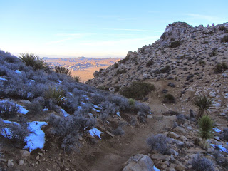
View north from the saddle on Ryan Mountain Trail, Joshua Tree National Park
4:03 - Saddle. I ponder the side path to high point 5238 but I’ll have to leave it for another time. Warm sun blankets the desert to the north, framed by V-shaped mountainsides on both sides of me. I’m eager to emerge into the sun again. There are still hikers heading to the peak and flirting with nightfall. At eight minutes from the saddle, it feels good to step from the brisk shade into the warm sun. I’m enjoying snapping pictures of the golden desert in the magic hour. Soon the trailhead parking lot comes into view far below. I’m eager to capture the sunset.

North from Ryan Mountain Trail toward the trailhead, Joshua Tree National Park

As I round the north flank of the mountain, the near-full moon comes into view rising in the east. My pace is intent now to ensure line-of sight with the setting sun and I’m rewarded with a superb Kodak moment (4:39). Sunset as seen from Ryan Mountain Trail, Joshua Tree National Park Instantly the lighting changes from vibrant gold to muted gray. I now focus on the rising lunar globe framed by massive boulders and lanky Joshua trees. Rock climbers are still perched on the gigantic monoliths and balancing on high wires. Rock climbers after sunset near Ryan Mountain trailhead, Joshua Tree National Park I saunter at a crawl as I savor the beauty of desert dusk.
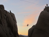
Moonrise as seen from Ryan Mountain Trail, Joshua Tree National Park
5:00 - End hike. There are about a dozen cars in the parking lot and it’s a brisk 52 degrees. I wander over to look at an Indian cave as noted by the sign. I linger in the twilight reluctant to say good-bye to this extraordinary place. As I drive through the park I am treated to spectacular silhouettes of Seussian features against an azure blue sky. Unfortunately, a thoroughly enjoyable outing is somewhat marred by having to wait in a long line of cars to exit the park. This is ridiculous! The line apparently serves no purpose as the ranger at the entry station simply waves each car through as it stops. I hope to God that this absurd practice doesn’t show up at the newly named San Gabriel Mountains National Monument.

Moonrise as seen from Ryan Mountain Trail, Joshua Tree National Park
Epilog - What a great first hike for the new year! Spectacular scenery, a fine trail (except for all the stair steps), an impressive peak, pleasant weather, a picturesque sunset and moonrise, and a splendid introduction to the interior of this amazing national park. And I get to cross off an HPS peak. I’m eager to return to this desert wonderland for more exploration. icon


*Elevation Note: Usually a peak has a standard published elevation. For a peak as popular as Ryan Mountain, it’s surprising that there are at least four different elevations attributed to this peak:
5457’ - Sign on summit, USGS topo map, Sierra Club Hundred Peaks
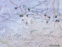
5458’ - Official park map Joshua Tree National Park map, Ryan Mountain Trail area
5460’ - Peakbagger.com
5461’ - Park map (online and kiosk) and National Geographic map (rev. 2005)


FUN FACT: The Joshua tree (Yucca brevifolia) is not really a tree. It has no tree rings. It’s a member of the yucca family. Joshua trees have shallow roots and grow slowly, taking hundreds of years to reach a mature height of 30 feet.

hiking icon  See Joshua Tree hikes at Dan's Hiking Pages

NEXT > Joshua Tree: Indian Cove and Mount Mel - Jan. 4, 2015
PREVIOUS > Joshua Tree: 49 Palms Oasis - December 29, 2014

Wednesday, December 31, 2014

Jones Peak and Hastings Peak - December 31, 2014

View southwest from Bailey Canyon Trail toward Pasadena and the last sunset of 2014
See Jones Peak Hike Description at Dan's Hiking Pages

Jones Peak holds a special place and for me. It was the first summit I climbed in the San Gabriel Mountains. Every day in my drive to and from work on the 1-210 Foothill Freeway, I could see the trail zig zagging up the mountain to the pointed peak towering over Sierra Madre. So on April 15, 1995, my son and I climbed the 3.3 miles to the top of 3375-foot Jones Peak. Ten days later I bought John Robinson’s Trail of the Angeles and so started my love for hiking in the San Gabriels. As I start my twentieth year of hiking the Angeles, it’s fitting to revisit Jones Peak. And I can add Hastings Peak to it and be able to check off another summit from the Sierra Club Lower Peaks list to end the year. The hike is about 9 miles round trip with 3,000 feet in elevation gain.

I leave the house at 11:20, which is unusually late for me to go hiking. But the morning was cold and I was having a hard time motivating myself to get going. I navigate my way to Bailey Canyon Park in Sierra Madre. There are about 10 cars in the parking lot. The air is brisk but I figure I’ll be fine in my t-shirt once I get going.

View north on Bailey Canyon Trail, Sierra Madre
11:50 - Begin Hike. I follow the paved service road past the flood control basin and begin my walk into nature. It’s been six years since I’ve hiked to Jones Peak and I’m a little excited. Recent rain has brought life to plants and grass. I love the freshness from yesterday’s rain. A remnant or golden leaves hang onto the sycamores as they go dormant for the winter (yes, SoCal has seasons!). In five minutes I pass the bridge to Live Oak Nature Trail, and in another four minutes pass the junction to Bailey Canyon Falls.

View southwest from Bailey Canyon Trail toward Sierra Madre and Los Angeles
Now I begin the earnest climb. The tiny white flowers of wild cucumber are about the only thing in bloom. Wild cucumber (Marah macrocarpa) blossoms along Bailey Canyon Trail above Sierra Madre Soon views begin to open up of the San Gabriel Valley and beyond. Haze mutes the horizon. To the north up canyon, Hastings Peak stands regally inviting me to climb it. I love the aroma of the chaparral. Lots of switchbacks keep me walking in all directions. Trail volunteers have been busy building steps and retaining fences. The warm sun feels good. As always on this trail, I encounter other hikers coming and going, but it doesn’t feel crowded.

View north from Bailey Canyon Trail toward Hastings Peak, left, Angeles National Forest
12:24 - MacCloud Saddle, 1.0 mile from the start. The canyon walls get steeper and more rugged. Sugar bush sports its pink bud clusters. Sugar bush (Rhus ovata) bud clusters along Bailey Canyon Trail above Sierra Madre I’m really enjoying the beauty of the canyon. A blimp floats above Pasadena. Being December 31, it does not escape me that thousands of Rose Parade viewers are heading to Pasadena to find their spots along Colorado Boulevard. I’ve done that many times with family and friends over the years. But tonight I’ll enjoy a warm bed and tomorrow I’ll watch the parade on TV while blogging about my hiking adventures.

View west from Bailey Canyon Trail toward cabin foundation, Angeles National Forest
1:09 - Cabin foundation, 2.2 miles from the start. I sit on the stone wall and have a snack. Since the last time I was here, a bronze plaque has been mounted on the wall. Cabin foundation, Bailey Canyon Trail above Sierra Madre, Angeles National Forest It reads, “George’s Cabin” and I’m amused by the story. I’ll let you hike here to read it for yourself. Another man arrives to check out the foundations. Strangely, he is not familiar with the well-known story alluded to on the plaque and the spoof is lost to him.

View north from Bailey Canyon Trail toward Hastings Peak, left, Angeles National Forest
I leave the foundation at 1:22 and continue climbing. The trail gets steeper in this section and I’m getting a good workout. I enjoy the richly textured chaparral, fresh air, and blue skies. There virtually no shade on the trail and the warm sun is welcome on this brisk winter day (this trail can be punishing in full sun of summer…I know!). Through the distant haze, I can see the sun glistening off the Pacific Ocean. View south from Bailey Canyon Trail above Sierra Madre in the Angeles National Forest As the trail bends around the backside of Jones Peak, I encounter a small patch of snow in the cold shade (yes, it’s winter in SoCal!).

2:10 - Jones saddle, nearly 3.3 miles from the start. I now have a view east toward snow-covered Ontario Peak. It’s cold in the shade and I’m eager to climb the steep pitch south to the summit and warm sunshine. Gosh, this is steep.

View east from Jones Peak (3375’), Dan Simpson, Angeles National Forest
2:16 - Jones Peak (3375’), 3.3 miles from the start. It’s sunny but a breeze is chilling. I put on my long-sleeved shirt. A couple other guys are here. The one guy who I met at the foundation is just leaving. I enjoy chatting with Jonas, who is a volunteer with the distinguished Sierra Madre Search and Rescue. Jonas is carrying a full pack with equipment; today is a condition hike for him, just to stay in shape. I always so appreciate the huge sacrifice these dedicated volunteers make. I hope and pray I never need their service.

Northern panorama from west to east as seen from Jones Peak (3375’), Angeles National Forest

Jonas leaves the peak heading south down firebreak. View south from Jones Peak (3375’) toward Arcadia and Sierra Madre, Angeles National Forest As I’m snapping pictures, the wind kicks up and I’m amazed how quickly the weather goes from comfortable to frigid. Man it’s cold! I’m first impulse is to hightail it down the mountain and skip Hastings Peak. I leave the summit at 2:44 and arrive at the saddle in four minutes. Amazingly, it’s not cold anymore! I quickly get a change of heart and decided to continue. After a sandwich and putting on my gloves, I proceed north climbing the steep trail. The warm sun feels good and there is little wind.

View south toward Jones Peak (3375’) from Hastings Ridge junction, Angeles National Forest
3:01 - Hastings Ridge junction. To the right is the crossover trail descending north into Little Santa Anita Canyon to intersect Mount Wilson Trail. I turn left and head west up the board ridge. It’s a good path with great views. Nearby Mount Harvard and Mount Wilson dominate the northwest skyline. Ahead, Hastings Peak stands prominently on this ridgeline. I have striking views south into Bailey Canyon and ponder how high I’ve climbed.

View northwest from highpoint 3724’ on Hastings Ridge toward Hastings Peak (left), Mount Harvard, and Mount Wilson, Angeles National Forest
3:14 - Highpoint 3724. I’ve been here once before on a hot summer day in July 2004 coming up from Little Santa Anita. On that hike was the first I heard about Hasting Peak, having seen it mentioned on the sign at the junction. I didn’t know if it was this peak or the next one up the ridge (and it didn’t show on the map), so I stopped here and went back because the hike was getting long on hot. So Hastings Peak has been on my hit list for 10 years.

I continue west along the undulating ridge enjoying the views and feeling excitement about bagging a listed peak to end the year. I also contemplate the reality that it will be dark before I complete this hike…oh no, I just remembered that Bailey Canyon Park closes at sunset…will my car be locked in?! Dang! Oh well, I guess I’ll face that situation later. For now, I continue to the peak. At 3:25 I reach the base of the final pitch to the summit. It’s quite steep now. I encounter more small patches of snow.

View west from Hastings Peak (4000’+) toward Monrovia Peak (left), Angeles National Forest
3:34 - Hastings Peak (4000+’) - I’m here! Great 360 panorama. At least 25 named peaks in the San Gabriels can be seen from here on the northern panorama. Northern panorama from west to east as seen from Hastings Peak (4000’+), Angeles National Forest The San Gabriel Valley sprawls out in the southern panorama, muted by haze. The survey maker indicates that it was placed in 1940. I’d love to sit up here for an hour in more clear weather on a warmer day just soaking in the views. But it’s cold and getting dark soon so my visit is brief. I leave the peak at 3:46.

View northwest toward Hastings Peak from Bailey Canyon Trial above Sierra Madre, Angeles National Forest
I retrace my steps down the ridge at a good clip. The sun feels good. I reach highpoint 3724 at 4:05, the junction at 4:15, and Jones saddle at 4:22. I move my headlamp from the pack to my pocket. The soon-setting sun casts a golden glow on the surrounding chaparral. As I descend lower into the canyon and the sun drops lower to the horizon, I’m hoping to have line of sight to see the last sunset of 2014. At 4:54 I get my last shot of the sunset. I pass the cabin foundation at 5:02. View south after sunset from Bailey Canyon Trail at the cabin foundation, above Sierra Madre, Angeles National Forest The city beyond the v-shaped canyon is turning into a blanket of twinkling lights. I try to call the Sierra Madre PD to let them know my car is in the parking lot at Bailey Canyon Park and to see if I can keep it from getting locked in, but I’m not getting reception.

View south after sunset from Bailey Canyon Trail toward the San Gabriel Valley, above Sierra Madre, Angeles National Forest
I resist using my headlamp for as long as I can since I prefer ambient light. As I’m negotiating a switchback my peripheral vision spots what appears to be a small back animal near my feet. It startles me, then I realize it is my shadow being cast by the moon. At 5:21 I finally get my call through to the police dispatcher and she says she’ll alert the officer on patrol. I finally switch on my headlamp on at 5:39. Even with light, walking in the dark is slow. I’m enjoying the beauty of nightfall. Temperature wise, I’m still comfortable without my third layer.

Foothill yucca (Yucca whipplei) on Bailey Canyon Trail, Angeles National Forest
6:17 - End hike. I am elated that the parking lot gate has not been closed and there is no ticket on my car. It’s 44 degrees.

Epilog - What an enjoyable hike to end the year! Superb trail, rich chaparral, freshness after the rain, warm sun, blue sky, splendid views, a familiar peak and new peak, and great exercise. What a blessing to live next to such amazing mountain range and be able to hike. icon

See Jones Peak Hike Description at Dan's Hiking Pages

Plants See Plants in Bailey and Rubio Canyons, Dan's Hiking Blog
    - March 27, 2011

Monday, December 29, 2014

Joshua Tree - 49 Palms Oasis - December 29, 2014

View north from Fortynine Palms Canyon Trail toward the oasis, Joshua Tree National Park
The wild and strange topography of Joshua Tree National Park is an amazing treasure of natural beauty. As a lifelong SoCal resident and avid hiker, I’m almost embarrassed to admit, that before now, I’ve never been to JTNP. With my daughter’s recent move to Twentynine Palms, I now have an ideal gateway to explore “The Park,” as locals call it.

Joshua Tree National Park encompasses more than 800,000 acres and straddles the boundary between the Mojave and Sonoran deserts in Southern California. The park consists of six mountain ranges with ten peaks higher the 5,000 feet. Its surreal landscape with towering rock formations, jumbles of boulders, and gangly Joshua Trees, has been described as Seussian, resembling the fanciful illustrations of children’s author Dr. Seuss. JPNP is located about 120 miles east of Los Angeles and about 12 northeast of Palm Springs. Interstate 10 runs along the southern boundary, Highway 62 borders the west and north, and Highway 77 borders the east.

Fortynine Palms trailhead, Joshua Tree National Park
I chose Fortynine Palms Oasis for my first hike in JTNP. It isn’t too far from my daughter’s home, fit nicely within the limited time I had on our short stay, and is highlighted in park literature as a feature attraction. As a Christmas gift, my daughter gave me the book, Joshua Tree: The Complete Guide by James Kaiser. It’s beautifully done and I began to devour it immediately. His hike description for 49 Palms Oasis is compelling and armed me for the hike.

On Hwy 62 (29 Palms Hwy), I drive west from Twentynine Palms a few minutes to Canyon Road (1.75 miles east of Indian Cove Road). It’s easy to miss but the small animal hospital on the corner helps as a landmark. I turn left (south) and drive through open desert 1.7 miles to the trailhead at the base of the mountains. There are about 10 cars in the paved parking lot. Trailhead amenities include informational signage, a pit toilet, and a split-rail fence creating a funnel into the trail. I’m eager to hike.

View northwest from Fortynine Palms Canyon Trail toward the trailhead
9:04 AM - Begin hike. It’s a brisk 46 degrees and I’m wearing a heavy flannel shirt. The trail immediately begins to climb south and southeast through the barren landscape and massive rock outcroppings. Views of Twentynine Palms and the expansive desert to the south open up. The warm sun feels good as I weave in and out of patchy shade created by the slopes and the sun low in the sky following its winter path. The trail grade is comfortable and my pace is relaxed as I enjoy the strange beauty of the desert.
Barrel cactus on Fortynine Palms Oasis Trail, Joshua Tree National Park Plant at Fortynine Palms Oasis, Joshua Tree National Park Jumping cholla on Fortynine Palms Oasis Trail, Joshua Tree National Park
It’s going to take some work to learn the flora of the high desert. I can identify a few plants, like jumping cholla, barrel cactus, Joshua tree, and the ubiquitous creosote bush, but many of the other plants are foreign to me. Everything is so different from my local San Gabriel Mountains with its thick chaparral, woodsy riparian corridors, oak woodlands, and majestic conifer forests.

View east into Fortynine Palms Canyon, Joshua Tree National Park
The trail angles southeast and I reach a hip of a ridge at 9:17. I now have views into 49 Palms Canyon and the ragged, rocky ridgelines beyond. The trail doubles back and ascends south. I shed my flannel shirt as I climb in the open sun. I’m really enjoying myself. The trail reaches another hip offering more views into the canyon hundreds of feet below. From the topography, I don’t see how the canyon bottom will rise to meet the current trajectory of the trail. In fact, I now see what appear to be palm trees peeking out far below. Kaiser’s trail guide lists an elevation change of 360 feet. I had interpreted that to be total gain. But since I’ve climbed that amount already and the rest of the hike is downhill from here, I guess I’ll be doubling that gain with my return trip. I’m generally not fond of upside down hikes. Later when rereading Kaiser’s description, I see he does mention descending toward the oasis. He should have put it in the Trial Info box so that readers quickly and easily see that the total elevation gain is 660 feet. 49 Palms Oasis hike description by James Kaiser, Joshua Tree National Park

View south into Fortynine Palms Canyon, Joshua Tree National Park
From here the trail ascends slightly for a couple more minutes then starts its descent into the canyon (9:27). The rugged, barren landscape is eerily beautiful. As a trailbuilder, I admire the various sets of rock steps along the trail. Rock steps along Fortynine Palms Oasis Trail, Joshua Tree National Park A solo hiker passes me…my first encounter for the hike. I snap pics of a few plants for further investigation. A party of three passes me climbing out. Soon I emerge to my first full view of the oasis below, nestled in morning shade.

View south toward Fortynine Palms Oasis, Joshua Tree National Park
9:54 - Fortynine Palms Oasis. It’s cool in the shade and I put on my flannel shirt. The destination is not particularly impressive to me. Signs read, “Sensitive Biological Area, Please Stay on Designated Trails.” There are others lingering near the lower end of the palm grove, so I climb to the upper end to look around. I make no attempt to count the palm trees to verify if there are 49, but in looking at the pictures later, I see the number of trees generously exceeds 49. I climb around the boulders exploring. Small ponds of water don’t look inviting to drink but the trees seem to enjoy the hydration amidst a desolate landscape. Fortynine Palms Oasis, Joshua Tree National Park Park guests are coming and going. As one who prefers destinations of peaks and waterfalls, my attention is drawn to the rocky crags high above as I ponder their climbablity. View east from Fortynine Palms Oasis, Joshua Tree National Park And throughout the hike I’ve pondered if there is a reasonable alternate route to get here coming up the canyon. View east into Fortynine Palms Canyon, Joshua Tree National Park From my observations on the ground and in studying the topo map and Google Earth, it looks like a route is possible starting near Encelia Road behind Stater Bros. It certainly would not be a hike that the Park Service would promote to tourists, but as an adventurer, I am lured to it.

View north ascending from Fortynine Palms Oasis, Joshua Tree National Park
10:22 - Leave oasis and immediately step into the warm sun and shed my flannel shirt. The trail is busy now with lots of hikers coming and going. Some are carrying their jackets and sweatshirts. I’m rarely out of earshot of others during the entire return trip. I’m working up a sweat in these mid 50s temps. I can’t imagine hiking here on a summer mid-day. At 10:43, I reach the highpoint hip and begin my descent. A vast desert sprawls out to the north with patches of human habitation. I can see the massive Twentynine Palms Marine base bordering the mountains across the basin. I’ve heard that it is the largest military base in the U.S.

10:56 - I reach the next hip before my final descent and take a short side jaunt to a craggy outcropping. It provides an ideal perch to capture the sweeping panorama to the north.

Northern panorama of Mojave Desert from Fortynine Palms Oasis Trail, Joshua Tree National Park

A pyramid-shaped peak near the trailhead far below calls me to climb it...on another day. My descent is entirely in the sun now and I enjoy the fascinating tan scenery.

View north toward Fortynine Palms trailhead
11:18 - End hike. There are 24 cars in the parking lot on this Monday morning and it’s 56 degrees.

Epilog - What a pleasant outing for my first hike in Joshua Tree National Park. The cool weather was most agreeable. Warm sun, amazing landscape, sweeping panoramas, splendid trail, intriguing plants, interesting destination. This short 3-mile round-trip hike with 660 feet in total elevation gain was an ideal introduction to hiking in this amazing desert place. I am eager to return for my next adventure in JTNP. icon

Be Prepared and Aware
Trail elevation chart on kiosk at Fortynine Palms Oasis trailhead, Joshua Tree National Park
After the hike as I took a closer look at the trail map on the kiosk, I saw that it does show an elevation profile climbing the first half of this 1.5-mile trail, and descending the second half. And the text states that it “first climbs 350 feet and then descends 300 feet to the oasis.” That’s good to know, particularly for inexperienced trial users. It’s noteworthy that the kiosk sign also states in red, “Last year there were five helicopter rescues and eight carryouts from the 49 Palms Oasis Trail. Only one was because of injury. The remainder were due to medical conditions such as asthma, diabetes, or heart trouble.”

hiking icon  See Joshua Tree hikes at Dan's Hiking Pages

NEXT > Joshua Tree - Ryan Mountain - January 3, 2015