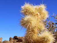
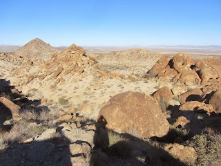
Joshua Tree National Park encompasses more than 800,000 acres and straddles the boundary between the Mojave and Sonoran deserts in Southern California. The park consists of six mountain ranges with ten peaks higher the 5,000 feet. Its surreal landscape with towering rock formations, jumbles of boulders, and gangly Joshua Trees, has been described as Seussian, resembling the fanciful illustrations of children’s author Dr. Seuss. JPNP is located about 120 miles east of Los Angeles and about 12 northeast of Palm Springs. Interstate 10 runs along the southern boundary, Highway 62 borders the west and north, and Highway 77 borders the east.
I chose Fortynine Palms Oasis for my first hike in JTNP. It isn’t too far from my daughter’s home, fit nicely within the limited time I had on our short stay, and is highlighted in park literature as a feature attraction. As a Christmas gift, my daughter gave me the book, Joshua Tree: The Complete Guide by James Kaiser. It’s beautifully done and I began to devour it immediately. His hike description for 49 Palms Oasis is compelling and armed me for the hike.
On Hwy 62 (29 Palms Hwy), I drive west from Twentynine Palms a few minutes to Canyon Road (1.75 miles east of Indian Cove Road). It’s easy to miss but the small animal hospital on the corner helps as a landmark. I turn left (south) and drive through open desert 1.7 miles to the trailhead at the base of the mountains. There are about 10 cars in the paved parking lot. Trailhead amenities include informational signage, a pit toilet, and a split-rail fence creating a funnel into the trail. I’m eager to hike.
9:04 AM - Begin hike. It’s a brisk 46 degrees and I’m wearing a heavy flannel shirt. The trail immediately begins to climb south and southeast through the barren landscape and massive rock outcroppings. Views of Twentynine Palms and the expansive desert to the south open up. The warm sun feels good as I weave in and out of patchy shade created by the slopes and the sun low in the sky following its winter path. The trail grade is comfortable and my pace is relaxed as I enjoy the strange beauty of the desert.

|

|

|
The trail angles southeast and I reach a hip of a ridge at 9:17. I now have views into 49 Palms Canyon and the ragged, rocky ridgelines beyond. The trail doubles back and ascends south. I shed my flannel shirt as I climb in the open sun. I’m really enjoying myself. The trail reaches another hip offering more views into the canyon hundreds of feet below. From the topography, I don’t see how the canyon bottom will rise to meet the current trajectory of the trail. In fact, I now see what appear to be palm trees peeking out far below. Kaiser’s trail guide lists an elevation change of 360 feet. I had interpreted that to be total gain. But since I’ve climbed that amount already and the rest of the hike is downhill from here, I guess I’ll be doubling that gain with my return trip. I’m generally not fond of upside down hikes. Later when rereading Kaiser’s description, I see he does mention descending toward the oasis. He should have put it in the Trial Info box so that readers quickly and easily see that the total elevation gain is 660 feet.
From here the trail ascends slightly for a couple more minutes then starts its descent into the canyon (9:27). The rugged, barren landscape is eerily beautiful. As a trailbuilder, I admire the various sets of rock steps along the trail.
9:54 - Fortynine Palms Oasis. It’s cool in the shade and I put on my flannel shirt. The destination is not particularly impressive to me. Signs read, “Sensitive Biological Area, Please Stay on Designated Trails.” There are others lingering near the lower end of the palm grove, so I climb to the upper end to look around. I make no attempt to count the palm trees to verify if there are 49, but in looking at the pictures later, I see the number of trees generously exceeds 49. I climb around the boulders exploring. Small ponds of water don’t look inviting to drink but the trees seem to enjoy the hydration amidst a desolate landscape.
10:22 - Leave oasis and immediately step into the warm sun and shed my flannel shirt. The trail is busy now with lots of hikers coming and going. Some are carrying their jackets and sweatshirts. I’m rarely out of earshot of others during the entire return trip. I’m working up a sweat in these mid 50s temps. I can’t imagine hiking here on a summer mid-day. At 10:43, I reach the highpoint hip and begin my descent. A vast desert sprawls out to the north with patches of human habitation. I can see the massive Twentynine Palms Marine base bordering the mountains across the basin. I’ve heard that it is the largest military base in the U.S.
10:56 - I reach the next hip before my final descent and take a short side jaunt to a craggy outcropping. It provides an ideal perch to capture the sweeping panorama to the north.

A pyramid-shaped peak near the trailhead far below calls me to climb it...on another day. My descent is entirely in the sun now and I enjoy the fascinating tan scenery.
11:18 - End hike. There are 24 cars in the parking lot on this Monday morning and it’s 56 degrees.
Epilog - What a pleasant outing for my first hike in Joshua Tree National Park. The cool weather was most agreeable. Warm sun, amazing landscape, sweeping panoramas, splendid trail, intriguing plants, interesting destination. This short 3-mile round-trip hike with 660 feet in total elevation gain was an ideal introduction to hiking in this amazing desert place. I am eager to return for my next adventure in JTNP.
| Be Prepared and Aware After the hike as I took a closer look at the trail map on the kiosk, I saw that it does show an elevation profile climbing the first half of this 1.5-mile trail, and descending the second half. And the text states that it “first climbs 350 feet and then descends 300 feet to the oasis.” That’s good to know, particularly for inexperienced trial users. It’s noteworthy that the kiosk sign also states in red, “Last year there were five helicopter rescues and eight carryouts from the 49 Palms Oasis Trail. Only one was because of injury. The remainder were due to medical conditions such as asthma, diabetes, or heart trouble.” |
NEXT > Joshua Tree - Ryan Mountain - January 3, 2015


Thank you for posting! I look forward to reading about your hikes, Dan. :)
ReplyDeleteThank you, Jennifer! Happy hiking!
DeleteHey, Dan. I've hiked this trail twice. If it's a wet winter, there are nice wildflowers in there. Lots of lizards, too. Enjoy "the Park." :D
ReplyDeleteFirst time in 49 Palms.