On Hwy 62 (29 Palms Hwy) in Joshua Tree, I turn south on Park Blvd. and take an immediate right into the Joshua Tree Visitor Center. After buying a map and a plant guide, I swing over to Circle K and grab a couple hot dogs. Back on Park Blvd. I head into the park. As I approach the park entrance, I’m somewhat disconcerted about a long line of cars. I’m not fond of waiting in lines, but to wait in line to go hiking is just stupid. I reflect on the National Monument status that was recently imposed on the Angeles National Forest. I can’t help but to wonder if it will eventually lead to congestion and blockages.
Once past the long line at the entry station, I enjoy a pleasant drive through open desert with its gangly Joshua trees and fanciful jumbles of rocks. A dusting of snow adorns the mountainsides. As I pass Ryan Campground, the scenery begins to look familiar. I had flown around the area quite a bit with Google Earth, so now it seems I’ve been here before. I immediately recognize the ridgeline of Ryan Mountain and experienced a little of what a WWII bombardier might have felt when sighting a target that had become familiar to him by studying the aerial recon photos. Thankfully, I’m not being rocked by flack!
I pull into the large Ryan Mountain parking area and it is packed (approximately 65 cars). Thankfully a space opens up immediately. I’m feeling excitement as I gear up and get ready to go. Trail users are coming and going. It feels more like an amusement park than a hiking trail. I snap some pics of the information kiosks. Unlike my hike to 49 Palms Oasis last week where I was just wearing civvies and a fanny pack, today I’m outfitting for hiking and have appropriate layers for weather. Temps are in the mid 50s, but it could get windy and frigid on top.
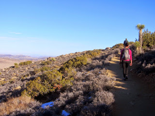
2:12 - Begin Hike. The trail gently climbs south toward the mountain as it passes between two massive outcroppings. Rock climbers are practicing their tight-wire acts between the huge boulders on the right. Patches of snow add variety to the barren landscape. There are many sets of rock steps along the trail. I have a fundamental philosophically difference with the NPS in now to build a trail. I believe a good trail flows with the topography and has as few manmade features as possible. Keep it natural. Oh well, maybe some of these tourists will discover the joy of hiking and graduate to less accoutremented trails as they grow in their outdoor acumen. And I don’t want to diminish the challenge of this trail, after all, it does climb more than 1,000 feet in elevation gain in 1.5 miles, which is more than a walk in the park.
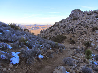
At about 0.1 mile the trail reaches a junction to Sheep Pass Group Campground to the east. I turn right as the trail begins its earnest climb. The warm sun feels good and I shed my long-sleeved shirt. The expanding views are stunning. To the north I see rock formations that I recognize from photos. As the trail contours left around the mountain, the round mass of the south end of Ryan Mountain ridge looms above. At its base, a massive rock formation with four distinctive knobs entices the imagination. I’m never by myself for long as parties of park guests come and go (more coming than going since I’m staying ahead of those who may be behind me). Even though I’m not fond of all these rock steps, I have a great appreciation for the huge expense of hand labor to build this trail.
2:46 - Saddle. To the left, a faint user path heads northeast up the broad mountainside to high point 5238’. I’m hoping to climb this peak on my way back. I’m now in the cold shade as the trail contours along the east side of the mountain. The route bends east and shortly I arrive at a hip with great views out over Queen Valley.
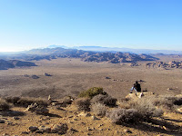
3:07 - Ryan Mountain (5457, 58, 60, or 61’...you choose*). Wow, what a splendid 360-dergree panorama! And what strange landscape! Tan desert with rocky formations stretches into the distant haze as far as the eye can see. It’s so very different from my San Gabriels, where a 5,000-foot peak would be covered with pine trees and/or thick chaparral. This feels more like the broad, barren summit of Mount Baldy (10,064’), only dotted with desert plants. And unlike Baldy, there is virtually no trace of human habitation anywhere aside from the highway cutting across the desert floor. And like Baldy, both San Jacinto and San Gorgonio are in view, only from the opposite direction.

|

|

|

|
There are 15 people here on the summit, in parties of one through five. I’m thankful there’s virtually no wind and I’m comfortable in a t-shirt. A large cairn (a man-made pile of rocks as a memorial or marker) stands on the summit. I stand on it to fully realize the panorama.

The late afternoon sun creates warm light across the desert and adds definition to the rock formations. Looking at the map and I can identify Queen Mountain (5677’) to the northeast and Quall Mountain (5814’) to the northwest. To the southwest is Keys View (5193’) and Mount Inspiration (5560+). This is a huge park to explore.
I leave the summit at 3:35 and take a short side jaunt to the first bump on ridge. Others are here on the outcropping of dark, jagged rock. After enjoying some varied views, I head north along the ridge and in a couple minutes arrive at the next bump and enjoy a few minutes of solitude and more amazing scenery. I am aware that I won’t have time to hit high point 5238’ on my return trip, so I don’t have to rush. I leave heading due east and in a couple minutes rejoin the trail. I arrive at the hip to catch the last rays of direct sun upon it as the orange ball dips below the ridge. The desert scenery is so picturesque. I put on my long-sleeved shirt as I descend into the deep shade.
4:03 - Saddle. I ponder the side path to high point 5238 but I’ll have to leave it for another time. Warm sun blankets the desert to the north, framed by V-shaped mountainsides on both sides of me. I’m eager to emerge into the sun again. There are still hikers heading to the peak and flirting with nightfall. At eight minutes from the saddle, it feels good to step from the brisk shade into the warm sun. I’m enjoying snapping pictures of the golden desert in the magic hour. Soon the trailhead parking lot comes into view far below. I’m eager to capture the sunset.

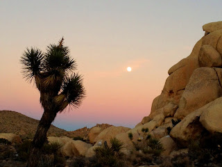
As I round the north flank of the mountain, the near-full moon comes into view rising in the east. My pace is intent now to ensure line-of sight with the setting sun and I’m rewarded with a superb Kodak moment (4:39).
5:00 - End hike. There are about a dozen cars in the parking lot and it’s a brisk 52 degrees. I wander over to look at an Indian cave as noted by the sign. I linger in the twilight reluctant to say good-bye to this extraordinary place. As I drive through the park I am treated to spectacular silhouettes of Seussian features against an azure blue sky. Unfortunately, a thoroughly enjoyable outing is somewhat marred by having to wait in a long line of cars to exit the park. This is ridiculous! The line apparently serves no purpose as the ranger at the entry station simply waves each car through as it stops. I hope to God that this absurd practice doesn’t show up at the newly named San Gabriel Mountains National Monument.
Epilog - What a great first hike for the new year! Spectacular scenery, a fine trail (except for all the stair steps), an impressive peak, pleasant weather, a picturesque sunset and moonrise, and a splendid introduction to the interior of this amazing national park. And I get to cross off an HPS peak. I’m eager to return to this desert wonderland for more exploration.
*Elevation Note: Usually a peak has a standard published elevation. For a peak as popular as Ryan Mountain, it’s surprising that there are at least four different elevations attributed to this peak:
5457’ - Sign on summit, USGS topo map, Sierra Club Hundred Peaks
5458’ - Official park map
5460’ - Peakbagger.com
5461’ - Park map (online and kiosk) and National Geographic map (rev. 2005)
| FUN FACT: The Joshua tree (Yucca brevifolia) is not really a tree. It has no tree rings. It’s a member of the yucca family. Joshua trees have shallow roots and grow slowly, taking hundreds of years to reach a mature height of 30 feet. |
NEXT > Joshua Tree: Indian Cove and Mount Mel - Jan. 4, 2015
PREVIOUS > Joshua Tree: 49 Palms Oasis - December 29, 2014


No comments:
Post a Comment