 See Fish Canyon Falls Hike Description at Dan's Hiking Pages

After many years of limited access to Fish Canyon Falls above Azusa in the Angeles National Forest, the public can now hike to the iconic waterfalls 365 days a year. On Wednesday evening, June 18, 2014, the new access trail was dedicated in a public ceremony, and on Saturday morning, June 21, 2014, 7 a.m., the trail was officially opened for public use. And I just had to be part of history.
I hike all over the San Gabriel Mountains, but since I live in Azusa, Fish Canyon has captured my fancy. Part of the allurement has been the fact that I couldn’t have it anytime I wanted it. The massive quarry operation in the mouth of the canyon had limited the public access, leaving as the primary legal options either a torturous climb over Van Tassel Ridge, or ridding through the quarry in a rented van provided by Vulcan Materials on a limited number of Saturdays.
I won’t recite the history here, since I’ve proffered much detail in my
blog post of January 29, 2011. And in my
Fish Canyon hike description page I provide an overview of the Fish Canyon saga along with links to numerous hike reports and blog posts of my many adventures in Fish Canyon.
As the calendar turned to 2014, Vulcan Materials Company was on the final stretch toward fulfilling the promised public access to Fish Canyon. The public debates were over, the mining permits were in place, and the legal barriers were hurdled. Now Vulcan had to build a parking lot and a trail through an active mining site by the prescribed August 2014 deadline. I was thankful for the opportunity to interact with Vulcan personnel to provide input and get updates. I was hoping the access trail would be completed by April or May before the springtime beauty morphs into scratchy weeds and bone-dry creeks. It’s not much fun hiking to a waterfall with no water!
On Saturday, February 15, Vulcan officials Peg Casey and Jeff Cameron gave me a tour of the access trail under construction. I was quite pleased with how it was shaping up and impressed with the excellence of planning and execution. It seemed to me that the trail could easily be open by mid-April. But alas, the project stretched on. I was disappointed by the delay but don’t suspect that there was any negligence or intentional protraction. Projects of this scope have a lot of complexities and moving parts. And Vulcan was working closely in partnership with the City of Azusa and interacting with the City of Duarte, the U.S. Forest Service, L.A. County, Army Corp of Engineers, and other entities.
I was excited on May 28 when Jeff Cameron from Vulcan informed me that the dedication and ribbon cutting was scheduled for Wednesday, June 18. On June 12, Jeff informed me that the City of Azusa had announced the event on its website, so I was free to publicize it. The response I got on my
Facebook Hiking Page reflected the public’s enthusiasm for the new access trail.
Wednesday, June 18 – Dedication Day!
I carefully arranged my schedule and transit plans to leave my office in L.A. and arrive at Vulcan’s Azusa Rock in time for the 5:30 p.m. ceremony. I am excited as I pull into the new trailhead parking lot at 5:17. Two hundred white chairs basking in the warm sun sit empty in front of a stage and podium. Another 24 chairs are lined up next to the stage for the dignitaries. I soon learn that the ceremony isn’t scheduled to start until 6:00. That would have been nice to know. There are probably 50 to 60 people here…mostly Azusa city staff, Vulcan employees, and dignitaries.
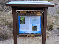
I enjoy interacting with various ones and reflect on how many years have led to this grand day. This parking lot will hold 70 cars of those who want to hike to Fish Canyon Falls 365 days a year, beginning Saturday! The new kiosks are beautifully done.

I snap pictures of the information to read later. At about 5:40 the sun drops behind Van Tassel Ridge providing some welcome shade on the event.
At 6:10 p.m., Conal McNamara, Assistant Community Development Director for the City of Azusa, acting as MC, steps up to the podium and begins the ceremony. Azusa Major Joe Rocha, council members, and various ones make remarks and presentations.

I am pleased to see City of Duarte Mayor Liz Reilly here, along with City Manager Daryl George. That community had fought vehemently against the plans that would make this day a reality…not that they were against the access trail, but they had a significantly different view of how mining should be carried out here. In addressing the gathering, Mayor Reilly speaks of partnership moving ahead into the future. The 45 people sitting in the audience seem swallowed up in the sea of 200 chairs.

Partially into the ceremony the P.A. system fails and presenters have to rely on old-school voices to be heard. Stan Bass, Senior Vice President of Vulcan Materials, also makes some remarks and speaks of continued partnership and earning public trust. I am greatly disappointed that no one from the U.S. Forest Service is here. Something is sadly wrong with them.
At 7:36 the speeches end and we transition over to the trailhead for the ribbon cutting. Dignitaries line up with the ribbon and a huge pair of gold scissors. Stan Bass from Vulcan is in the middle flanked by Mayor Rocha and Mayor Reilly on his right and left, with Azusa councilmen Angel Carrillo, Robert Gonzalez, Eddy Alvarez, and Uriel Macias, along with and Cheryl Kohorst and Mercedes Castro from the Azusa Chamber of Commerce. The photographer counts down, and snip. The crowd goes wild. We are invited to walk the new trail.


I rush back to the car and put on my tennis shoes and join the others for the historic walk. I stroll along with councilmen Gonzales, Macias, and Carrillo, Suzie Hsi (Field Deputy for County Supervisor Gloria Molina), and Peg Casey from Vulcan as she narrates our walk. Soon I take a little faster pace with Suzie. This is her first experience in Fish Canyon. I think about the thousands of feet that will tread on the path in the months and years to come. I meet Dan Hyke. We’ve corresponded by email on several occasions and so it’s nice to finally meet him face to face. What a great name for a hiker…Dan Hyke!


We arrive at the bridge and another new kiosk. Atisthan Roach and Mike Radcliff from Vulcan are here. Atisthan has been great friend of the public for quite a few years as she has been responsible for facilitating the Fish Canyon assess days. Last year she was transferred to Vulcan’s corporate headquarters in Alabama and I miss her timely emails and cheerful interaction. I’m delighted that she flew out for this event.

Soon Peg Casey arrives with Councilman Macias and Mayor Reilly. Jeff Cameron from Vulcan arrives by truck and we all enjoy a good conservation. It’s fun being with Atisthan and Peg again. During the public hearing stage of the mining proposal in 2010, I interacted with them a lot and they were incredibly responsive in providing answers to every question I had about the project.

It’s great to see Duarte’s Mayor here at this location and excited about the future. Hmmm, where’s Mayor Rocha and the other councilmen? They didn’t make it this far. Jeff takes a group back with him in his truck and Mike and I walk down the new trail together.
Mike and I arrive back at the trailhead at 8:06 as dusk settles over the San Gabriel Valley. My car is the last one in the lot. What a grand day and the culmination of many years of anticipation! Jeff Cameron and the other Vulcan Materials personnel have done an outstanding job in planning and building the new access Trail. It exceeds my expectations. The trail is now dedicated and Saturday opens a new era for hiking to Fish Canyon Falls.
Saturday, June 21 - Grand Opening Day!
The morning of Saturday, June 21 arrives and I’m eager to be part of the grand opening of the new Fish Canyon Falls access trail. I’m not sure what to expect in terms of crowds. The end of June is certainly not an ideal season to hike Fish Canyon, particularly in a drought year. But the news of the opening has been covered in the
newspaper and is lighting up social media. And since Vulcan has not offered its shuttle-ride access days this year as they were building the access trail, I’m thinking there may be a sizeable crowd today.
I arrive at Vulcan’s Azusa Rock gate at 6:20 a.m. I guess I am really eager, since the gate doesn’t open until 7 a.m. I’m the first to arrive. I double back to check out old trailhead for the route over Van Tassel Ridge, which I understand will be closing as Vulcan proceeds with mining operations on the ridge. The gate to the old parking lot is locked and three large boulders have been placed in front of it. Near the beginning of the old trail, a sign has been posted: “NOTICE OF TRAIL RELOCATION - Hikers: Be advised that his trail will soon close and be relocated to a new location on Fish Canyon Road. This trail will remain open until the location is completed. The new relocated trail is expected to be ready for public use on Saturday, June 21, 2014.”

I drive back to the Vulcan gate and just wait.
At 6:42 another car pulls up, and soon more cars come. A security guard comes out and says the gate is supposed to open at 7 a.m. At 6:55 a Vulcan employee walks down the driveway and opens the gate. It’s Jeff Cameron, who has been the point person on the construction of the access trail. I’m the first one to drive through the gate and into the new parking lot. I park near the kiosk and trail gate. Six other cars follow me in.
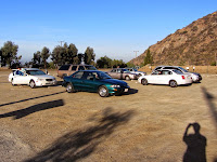
I figure I can be the first one on the trail, and if I keep a good pace, I can be the first one to hike the new access trail on opening day. I quickly exit my car, take a few pics, and hit the trail.
6:58 a.m. - Begin hike. I’m excited to be part of history. So many years have passed leading up to this moment where the public can freely walk through the quarry to Fish Canyon Falls. The temperature is pleasant and the canyon is still in full shade with the sun starting to land on Van Tassel Ridge. I was just on this path Wednesday for the dedication celebration, but today is different. I’m all by myself and I’m heading to the waterfalls.
My pace is quick as I want to be the vanguard. There’s a montage of thoughts bouncing in my head. I reflect on many shuttle rides through this quarry on access days, on my recent trips on this route, on years of public debate over the fate of this site, on the interacting with Vulcan personnel in the planning process, on what words I’ll type to memorialize this day, and on the hikers from six vehicles who are not far behind me.
The shire canyon walls always impress me. Massive pieces of equipment sit resting from their labors...wow I can actually walk this on a weekday and see them in operation! I soon pass to the west side of the quarry road via the crossing gate. I appreciate that Vulcan has, for the most part, erected the fence on only one side of the trail and trusts hikers to honor their request to stay on the trail and to keep out of the riparian and quarry areas.

In another five minutes I reach the “big rock.” Passing another beautifully-done informational kiosk, the trail transitions to a more natural footpath.
It’s more rustic than we’d expect of an established trail. Vulcan officials have explained to me that because their riparian restoration efforts were certified by the Wildlife Habitat Council, they are restricted in what they can do in clearing vegetation and grading the trail. Seems silly to me. Somehow we must find a good balance between conservation and human use.
7:12 - Arrive at the bridge. It’s taken me 14 minutes to walk the 0.7 mile from the parking lot to here. Another kiosk provides more information.
I am disappointed that no one has trimmed the tree branches that block the bridge. Vulcan can’t technically do it because it’s in the national forest. And the U.S. Forest Service isn’t doing it. I was going to do it myself but decided to let it stand to punctuate the problems with the FS. Various maintenance needs were reported to the FS over this past year, but they’ve done nothing. Portions of the trail are covered with rocks and there is a large tree that blocks the route. A Vulcan person told me that they had contacted the FS, but the person they talked with simply said, “Well, we can close the trail.” Typical government bureaucrat! And I don’t think it’s a matter of not having enough money. It’s a mentality. And they weren’t even at the dedication ceremony on Wednesday!! I’m about to cross the bridge into the national forest onto a trail that is in their inventory, yet the FS seems derelict in showing any sense of responsibility for the trail.

I cross the bridge at 8:13 and begin my hike on my beloved Fish Canyon Trail.

The creek is dry. A couple deer scamper up the mountainside. I’m still ahead of the others so my pace is earnest to stay ahead. Poison oak leaves are turning red. The non-native grasses and weedy plants are dead and encroaching onto the trail. There is virtually nothing in bloom except the California buckwheat. As the trail drops near the creek, it feels strange that a scene that in spring is amazingly beautiful with a gurgling stream and lush plants is now waterless and parched. The tree of heaven jungle feels like a jungle. A large white alder still blocks the path.

Really, how hard would it have been for the FS to bring in a chain saw and clear the trail for the grand opening! Maybe we do need the U.S. Park Service to come in and prop up the deficiencies of the FS.
After a while I’m finally treated to a little floral color with some splashes of scarlet larkspur along with some thistle, laurel sumac, and yucca. Poison oak intrudes into the trail in all the usual places and will certainly assault legs of those who are not vigilant to avoid it. The dead and parched vegetation really does overshadow the beauty of this canyon. It underscores the importance of
minding the seasons when selecting a hike. Typical I would not be on this trail in late June, particularly in a drought year, but today I’m a part of history.
I cross the stream coming down from Darlin’ Donna Falls and there is a trickle of water flowing. In a few more minutes I get to the main creek and it’s bone dry.
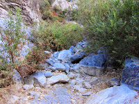
Climbing along the east wall now, I’m still in full shade. And I’m still ahead of everyone else. The rare
Dudleya densiflora is in bloom (
see blog post from 7-7-11). I’ll have to visit it on my return. There is an eerie silence as I approach the falls.
8:56 - Fish Canyon Falls. Certainly one of my fastest trips to here…just two minutes shy of an hour. There is no water flowing over the falls. There is some water in both the lower and upper pools, but not much. It’s strangely quite here. I snap pictures and enjoy a little solitude, knowing others are not far behind. I have five minutes to myself before a gentleman arrives. In another minute three more folks arrive. I wander into the upper pool and stand on a dry bottom where water would be nearly to my waist. Some creek monkey flower and sunflower add a touch of yellow to the setting. Pesky blood-sucking bugs fly around my face and bite my legs, which is not usually an issue in the spring when the water is flowing. But it’s a common sight today to see people swatting bugs from their faces.
Soon there is about 15 of us here, some with noisy voices. Most of those I talk with are here for the first time, and many of those read about it in the newspaper this week. It’s kind of a disappointing experience for them but they can look forward to March or April to enjoy the real Fish Canyon Falls. Others arrive and some leave. At one point it’s just two of us here, but not for long. Art and Anna Ramirez arrive; they are fellow Azusians who helped bring this day to reality. Today is a very different feel from the springtime access days in the past where hundreds would converge on a spectacular waterfall. I linger as the sun creeps down the face of the falls. I rarely find it easy to leave here. I’ve counted 48 people and four dogs who have arrived at the falls today.
10:25 - Leave the falls. The canyon is in full sun now. My pace is relaxed. I encounter a lone occurrence of Botta’s clarkia, aka farewell-to-spring…fitting for this first day of summer.
I stop to photograph the rare
Dudleya densiflora in bloom (
see blog post from 7-7-11). I show them to four others who are returning from the falls, including a young man I met at the dedication on Wednesday. We walk together, cross the dry creek, and in a few minutes take a side jaunt to Darlin’ Donna Falls. It’s still flowing…kind of meager, but it’s a waterfall. We continue along and I point out a few plants. Soon I let them go as I saunter along. Others are coming and going, but not like the throngs of the past.
As I pass Old Cheezer’s (the location of the interpretive sign describing
Dudleya densiflora and matilija poppy), I’m disappointed to see the “Dan” tree dead. It’s a mature white alder standing about 45 feet tall, about 25 feet below the trail. Years ago someone craved “Dan” into its trunk (a foolish act of vandalism which of course I don’t condone).
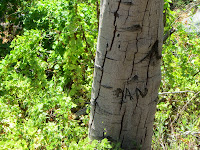
Now the tree stands stone dead. I have no idea if it’s related to the drought or the surrounding
cape ivy (Delairea odorata), a horribly invasive and destructive weed that covers 500,000 acres in California. Another white alder nearby is dead too.
It’s getting warm. An occasional hiker or small group comes up the trail. As I chat with some, many of them are here for the first time. I do a little exploring. In spite of the heat, dry creek, parched vegetation, and forest service negligence, I’m enjoying myself and glad to be here on this historic day.
1:40 - Bridge. Now for my return passage on the new access trail. It’s become hot. As I encounter others coming up the trail, I’m puzzled as to why people would start a hike in the middle of a hot day on a trail that is mostly exposed. No doubt many of these folks will find the outing to be unpleasant. It’s good to
mind the seasons. My pace is slow as I soak in the spectacular scenery of the quarry in the full sun.
2:20 - Finish hike.

There are 20 cars in the lot. From the point of leaving the falls until now, I counted 60 people heading to the falls; 25 of those were in the access trail section since I left the bridge at 1:40. So with the 48 people I counted at the falls and the 60 I counted after, and including me, there were 109 of us hiking to Fish Canyon Falls today between 7 a.m. and 2:20 p.m. And I was pleased that each of the five dogs I encountered on the trail today was on a leash.
Epilog - What a historic day! I have so many special memories of hiking to Fish Canyon Falls over the years. I grew to look forward to the access days and experiencing this remarkable setting with hundreds of others. I loved seeing so many just enjoying the outdoors. I’ve met lots of great people, ran into friends, made new friends, and swapped numerous stories with other hikers. I think I will miss the access days. But I’m starting to grasp the reality of what it means to hike here any day I want. I can hike here tomorrow. I can hike it once a month to photograph the seasons. I can hike it with a book and find a comfortable spot to just relax and read. I can explore. I can study botany or go bird watching. I can count tree rings. I can break in new boots. I can host out-of-town guests to a delightful outing. I like the possibilities!

But I am somewhat concerned with what may happen to this pristine canyon. The massive quarry operation that guarded the mouth of Fish Canyon was a blessing and a curse. The curse was that it restricted access to this beautiful canyon. The blessing was that it restricted access to this beautiful canyon! The quarry’s presence helped protect the canyon from overuse and abuse. We’ve seen what can happen in such places as Eaton Canyon, Hermit Falls, and Bonita Falls. We who love Fish Canyon need to stand together in united resolve and vigilance to project and preserve this natural resource.
 Like Fish Canyon Falls Facebook Page
See Fish Canyon Falls Hike Description at Dan's Hiking Pages
Like Fish Canyon Falls Facebook Page
See Fish Canyon Falls Hike Description at Dan's Hiking Pages (including a link list for my other blog posts for Fish Canyon)
NEXT > Van Tassel Ridge Hike - July 20, 2014
NEXT > Fish Canyon Falls Hike - October 25, 2014
PREVIOUS > Fish Canyon Hike - Farewell Tour - March 22, 2014


 I snap pictures of the information to read later. At about 5:40 the sun drops behind Van Tassel Ridge providing some welcome shade on the event.
 I am pleased to see City of Duarte Mayor Liz Reilly here, along with City Manager Daryl George. That community had fought vehemently against the plans that would make this day a reality…not that they were against the access trail, but they had a significantly different view of how mining should be carried out here. In addressing the gathering, Mayor Reilly speaks of partnership moving ahead into the future. The 45 people sitting in the audience seem swallowed up in the sea of 200 chairs.
 Partially into the ceremony the P.A. system fails and presenters have to rely on old-school voices to be heard. Stan Bass, Senior Vice President of Vulcan Materials, also makes some remarks and speaks of continued partnership and earning public trust. I am greatly disappointed that no one from the U.S. Forest Service is here. Something is sadly wrong with them.


 Soon Peg Casey arrives with Councilman Macias and Mayor Reilly. Jeff Cameron from Vulcan arrives by truck and we all enjoy a good conservation. It’s fun being with Atisthan and Peg again. During the public hearing stage of the mining proposal in 2010, I interacted with them a lot and they were incredibly responsive in providing answers to every question I had about the project.
 It’s great to see Duarte’s Mayor here at this location and excited about the future. Hmmm, where’s Mayor Rocha and the other councilmen? They didn’t make it this far. Jeff takes a group back with him in his truck and Mike and I walk down the new trail together.


 I drive back to the Vulcan gate and just wait.
 I figure I can be the first one on the trail, and if I keep a good pace, I can be the first one to hike the new access trail on opening day. I quickly exit my car, take a few pics, and hit the trail.

 In another five minutes I reach the “big rock.” Passing another beautifully-done informational kiosk, the trail transitions to a more natural footpath.
 It’s more rustic than we’d expect of an established trail. Vulcan officials have explained to me that because their riparian restoration efforts were certified by the Wildlife Habitat Council, they are restricted in what they can do in clearing vegetation and grading the trail. Seems silly to me. Somehow we must find a good balance between conservation and human use.

 The creek is dry. A couple deer scamper up the mountainside. I’m still ahead of the others so my pace is earnest to stay ahead. Poison oak leaves are turning red. The non-native grasses and weedy plants are dead and encroaching onto the trail. There is virtually nothing in bloom except the California buckwheat. As the trail drops near the creek, it feels strange that a scene that in spring is amazingly beautiful with a gurgling stream and lush plants is now waterless and parched. The tree of heaven jungle feels like a jungle. A large white alder still blocks the path.
 Really, how hard would it have been for the FS to bring in a chain saw and clear the trail for the grand opening! Maybe we do need the U.S. Park Service to come in and prop up the deficiencies of the FS.
 Climbing along the east wall now, I’m still in full shade. And I’m still ahead of everyone else. The rare Dudleya densiflora is in bloom (see blog post from 7-7-11). I’ll have to visit it on my return. There is an eerie silence as I approach the falls.


 Now the tree stands stone dead. I have no idea if it’s related to the drought or the surrounding cape ivy (Delairea odorata), a horribly invasive and destructive weed that covers 500,000 acres in California. Another white alder nearby is dead too.

 There are 20 cars in the lot. From the point of leaving the falls until now, I counted 60 people heading to the falls; 25 of those were in the access trail section since I left the bridge at 1:40. So with the 48 people I counted at the falls and the 60 I counted after, and including me, there were 109 of us hiking to Fish Canyon Falls today between 7 a.m. and 2:20 p.m. And I was pleased that each of the five dogs I encountered on the trail today was on a leash.


