Showing posts with label San Bernardino National Forest. Show all posts

Saturday, March 21, 2015

Etiwanda Falls Hike - March 21, 2015

Etiwanda Falls - big falls, San Gabriel Mountains, San Bernardino National Forest
Gurgling, babbling, and dancing, two vibrant streams flow south from the rugged canyons of the east San Gabriel Mountains above Rancho Cucamonga. As the streams near the valley, they become one and the water cuts through granite bedrock and tumbles through a series of small cascades and vertical drops known as Etiwanda Falls. The life-giving water nourishes an oasis of alder, maple, bay, sycamore, willow, and a host of shrubs and wildflowers.

I’ve known of Etiwanda Falls for years, but with its diminutive stature and the less-than-glamorous dirt-road route to get there, it had never risen high on my hit list. But the first full day of spring begs to be celebrated by hiking to a waterfall. And since I’ve already visited most of the noteworthy falls of the San Gabriels, I decided I’d give Etiwanda Falls a visit. In going online to find a good trail guide, I found none. It reminded me why I started Dan’s Hiking Pages. There were lots of write-ups, but nothing that gives a clear and reliable description of how to hike to the falls. So after I pieced together various postings, I was ready to hike.

My friend Tom and I leave Azusa shortly after 7 AM on Saturday morning and head east on the I-210 freeway. The marine layer transitions to hazy sun. We exit on Dry Creek Blvd. in Rancho Cucamonga and drive north to the trailhead at the upper end of Etiwanda Avenue. There are dozens of cars parked along the dirt road but we are able to find a spot right up front.

Before us lies 1,200 acres set aside by San Bernardino County as the North Etiwanda Preserve, a habitat preservation consisting primarily of a unique Riversidean Alluvial Fan Sage Scrub plant community. The trail to the falls is a dirt road that heads north through the preserve, briefly crosses some private property, enters the San Bernardino National Forest, and ends at the falls. It climbs 700 feet in 1.6 miles. The route is entirely exposed so a hike would be brutal on a hot sunny day. Today’s forecast is for the mid-70s and so we will be fine, particularly with an early start.

7:50 AM - Begin hike. We wander up the rocky dirt road. The temperature is pleasant. The rugged San Gabriels dominate the horizon before us. After a few minutes we take a short side jaunt to check out the kiosk pavilion. It has several signage displays providing information about plants, animals, and history. The vandalism and trash is unfortunate. Back on the road we continue north. There are lots of people on the trail.

The surrounding sage scrub plant community is alive and vibrant. The richly textured patchwork of shrubs include mountain lilac, white sage, black sage, California sagebrush, chamise, deer weed, scale broom, California buckwheat, hoaryleaf ceanothus, yerba santa, and chaparral yucca. Much of it is in bloom, with the mountain lilac being particularly showy. We enjoy identifying plants and smelling the wonderful aromas of sage. Lizards scamper along the ground and butterflies flutter through the air.

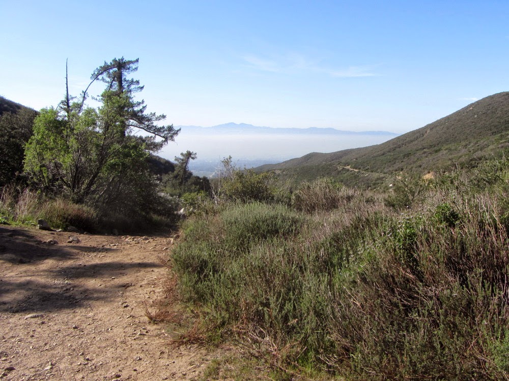
The climb is steady. The rock-ridden road makes walking a little tedious. Behind us, the view of Pomona Valley is far reach but muted by the marine haze. Saddleback pokes above the marine layer in distant Orange County. I’m curious and about loud engine noise coming from the valley to the south. It kind of sounds like aircraft engines. Oh, could it be the speedway? Tom says that NASCAR is in town this weekend, so I bet that’s what it is. We reach a half mile maker at 8:24. It’s made of thick iron and has the characters cut out in relief, so it would be very difficult to vandalize. It states the elevation at 2247’.

8:25 - Four-way junction, 0.514 mile from the start. A stone pillar has a sign pointing left (west) with a hiker icon, and a sign pointing right (east) with a picnic table icon. The official preserve map does not show the road that continues straight northward since it exits the preserve boundary. We turn right (east) and walk about 50 yards to the edge of wash to look down into the canyon below. The water flowing down East Etiwanda Creek would have tumbled over Etiwanda Falls, about a mile upstream. Back at the junction we continue north. In about 50 yards we pass through an open gateway. The climb gets steeper. Our pace is casual as we enjoy good conversation and stop to admire plants and soak in the beautiful scenery.

At 8:53 we pass a junction where a road heads east along the base of Prominence 2917. It’s been registered as a provisional summit on Peakbagger.com, so in my preparation I wondered if there was a route to the top. From Google satellite view, it appears that the thick brush forms an impassable barrier. And as we walk along, I can’t see any reasonable route through the hostel vegetation to the summit. We pass along the east flank of the prominence as the topography becomes hillier. There are a still scads of people coming and going to the waterfalls. The prevalence of graffiti is a strong refutation of the theory of evolution. The leaves of alders and sycamores in the creek far below shimmer in the morning sun. My eyes are drawn to surrounding peaks and wonder if they have names and ways to reach them.

As we reach a tributary coming in from the left (west) we are greeted with plants we’ve not experienced yet today: poison oak, mule fat, canyon dudleya, bigberry manzanita.

9:23 - Water transport feature. The preserve has various remnants from when early settlers used inventive was to tap and transport precious water for their ranches and farms. Today the transport is primarily by steel pipes. This grate-covered concrete box with water rushing through it is part of today’s water transport system. We are near the falls and we can hear the gleeful voices of visitors enjoying the setting. A use path heads into the brush and provides a means to access the canyon below the falls, but later we find that it is treacherous. We take the road as it veers left and curves back around. The view back toward the hazy valley is framed by the canyon. Our pace is still slow as we look at plants. The road terminates at the shady creek above the falls.
9:45 - Etiwanda Falls. What a delightful setting! A canopy of trees provides a welcoming oasis. There are lots of people sitting on the rocks eating, playing in the water, exploring, and generally enjoying the sylvan sanctuary. The falls from this vantage point are simply puny and consist of water cascading down a chute-like series of rocks dropping only about 15 feet. Beyond that pool the water pours over a lip and drops about 10 feet into another pool. The water then disappears over another lip into a deep gorge out of view. To see that falls will require some concerted effort and is not for the casual walker or faint of heart.

After hanging here awhile, we heard there is another falls up the creek. Two streams join here and we follow the path up the stream on the left (west). We carefully avoid the abundant poison oak. Eupatory and blackberry display their white flowers. The babbling brook is soothing to the ears. In less than 10 minutes we reach another waterfall: another cascade flowing down rocks into a pool, dropping about 20. This is really nice and we are the only ones here. We climb the rocks on the right to get above falls. The canyon walls are steep with textured rocks and varied vegetation. Color wildflowers accent the scene. We climb up stream a couple more minutes and find another waterfall. This one drops virtually about 7 feet into a pool. We hike a little further but decide it’s time to head back.

11:00 - Start back. We retrace our steps, carefully climbing over rocks and dodging poison oak. We encounter another group climbing up. We are really enjoying ourselves but the trash, graffiti, and carved-up trees are saddening. We arrive back at the main falls at 11:27. Still lots of people here. We take more pictures now that the falls are in the sun.

Etiwanda Falls - big falls, San Gabriel Mountains, San Bernardino National Forest
Back on the road about 65 yards from the creek, we decide to climb down the steep slope using a narrow path through the brush. We climb down and down being drawn by the hope of a good view of the big falls. We end up next to a huge oak tree high on the sheer wall above the creek and have a splendid view of the falls. The presence of a large graffiti tag at the bottom of the falls indicates that that location is reachable, probably from downstream. Our perch is somewhat precarious. Tom inadvertently dislodges some rocks that tumble down the shire rock face and crash to the canyon floor. This is not a good place to be. We carefully climb out and are relieved to reach a safe place. We take a use path back to the water transport feature.

View south, North Etiwanda Reserve, Rancho Cucamonga
After catching our breath and chatting with a young couple, we start back at 12:15. There are still people coming up the road and it’s beginning to get warm. We stroll down the rocky road and enjoy wildflowers Lupine, en route from Etiwanda Falls, North Etiwanda Reserve, Rancho Cucamonga and expansive views. We pass the four-way junction at 12:58. The valley before us is still muted by haze.

View north, North Etiwanda Reserve, Rancho Cucamonga

1:30 - Finish hike. It’s about 78 degrees, but it seems much hotter.

Dan Simpson and Tom Sanchez at Etiwanda Falls, San Gabriel Mountains
Epilog - What a nice outing to celebrate the first full day of spring! A vibrant plant community, beautiful wildflowers, sweeping views, rugged mountains, fresh air, sunshine, a woodsy sanctuary, and some charming waterfalls. It’s unfortunate that San Bernardino County and the Forest Service are negligent in dealing with the graffiti and vandalism. They need to remove the graffiti weekly and work with law enforcement to catch these criminals. There is a lot of the North Etiwanda Preserve I have yet to explore, including 10 interpretive stations. I certainly see why this place is so appealing to the locals. icon

icon  See Waterfalls of The San Gabriels at Dan's Hiking Pages

Saturday, May 10, 2014

Bonita Falls Hike - May 10, 2014

icon  See Waterfalls of The San Gabriels at Dan's Hiking Pages

Bonita Falls in the Lytle Creek area of the San Gabriel Mountains had eluded me for years. I had known of it but for some reason I had the idea that it was remote and difficult to reach. So sometime back when I learned that it was indeed quite accessible, I put it on my hit list. With a drop of 160 feet, Lower Bonita Falls is one of the tallest waterfalls in Southern California. According to canyoneer Christopher Brennen, there is actually a set of three waterfalls, Upper (190’), Middle (40’), and Lower (160’) for a total of 390 feet. The lower falls is the only one that is reasonable accessible without technical equipment and canyoneering skills.

I put together a go-packet from a number of online sources and I finally dedicated a day to pay a visit to this grand waterfall. Good weather was forecast and there should still be a decent flow from the winter and spring snow and rain, even though it has been quite meager this year.

I leave my house in Azusa at 8:36 a.m. and head east on the I-210. It’s gloomy and cool. I transition to the I-15 and a few minutes later exit Sierra Avenue and head north on Lytle Creek Road. I have to confess that I’ve never hiked this eastern portion of the San Gabriels. As I drive the meandering road, the beauty of this area exceeds my expectations. Rich, mature chaparral blankets the rugged mountainsides. Heavy gloom shrouds the ridge tops.

I stop at Lytle Creek Ranger Station to replace my annual Adventure Pass which has expired. I chat with the two FS employees and ask them what they think about the National Recreation Area legislation being proposed by Congresswomen Judy Chu. I’m shocked to learn that neither of them has heard about it!

Leaving the ranger station, I drive up the road another mile to the parking area just past the turn-off to Green Mountain Ranch. It’s 55 degrees and feels cold. I had mentioned to the ranger that an online write-up said to use the bridge to cross Lytle Creek. The ranger said that since the bridge is private property, forest users need to ford the creek. So I climb down to the creek from the parking area but see no place to cross without feet in the water. So climb back up to the parking area and check out the bridge. There are no signs that prohibited crossing it, so I decide on that route.

10:30 - Begin hike. Cross the Green Mountain Ranch bridge. The creek is running briskly below. Just short of the entrance to the ranch, I turn right (north) and follow the fence, and then shortly, turn left and follow the fence west. The route is not hard to follow but certainly not a formal trail. Soon I navigate through vegetation to the open wash. I had anticipated a trail to be more defined, but it’s basically find your own route. I’m enjoying the spring flowers.

The mouth of South Fork Lytle Creek is a wide boulder field flanked with steep mountainsides. Gloom still cloaks the ridge tops. I carefully pick my way west staying near the south side. Walking along a rock-covered creek bed is not my favorite kind of hiking. Every step is an opportunity to twist an ankle. There are some interesting metamorphic rocks with swirling patterns.

Various online accounts speak of lots of trash and graffiti, but so far I’ve encounter virtually no trash and very little graffiti. But soon the graffiti begins to appear. Urban vandalism meets the national forest. I chuckle at theory that humans evolved from animals. Animals never behave in a malevolent way. Clearly humans are distinct and unique creatures who have an amazing capacity for good and evil. To enjoy this hike, one must look beyond the immediate vandalism of pathetic humans and appreciate the rugged beauty of this special place. I encounter others who are coming and going. I don’t understand why people think that leash laws don’t apply to their dogs.

It’s supposed to be only about a half mile up the wash to the junction for the waterfalls. But it’s a tedious half mile requiring careful footsteps. I specially observe that every person I encounter is looking at his or her feet. I pause often just to look up and experience the beauty of my surrounds.

11:06 – Junction to falls. It’s a distinct path angling to the left into a side canyon. It might be easy to miss if one is not paying attention. The well-traveled path is clearly defined and easy to follow, meandering along the left of the watercourse. The flowing stream creates a pleasant soundtrack. Mature trees like oak, sycamore, and bay provide lots of shade while lush vegetation offers a very different feel from the rocky creek bed behind me. I choose to not allow the profusion of graffiti to spoil my enjoyment of the scenery.

11:20 - Bonita Falls. Wow, this falls really is bonita...pretty, beautiful. The water cascades in thin ribbons down the rocky face, some 160 feet. There is not a large volume of water, but it’s still impressive. People are coming and going. Dogs off leaches are braking and scrapping and creating a tense and disruptive situation. The flyer from the Forest Service says, “The access to the Bonita Falls viewpoint is not a developed trail and any hazards present are not mitigated.” Some guys have climbed the steep wall on the left to a high point, which I suspect is this “viewpoint.” I spend quite a while in a little flat area at the right of the pool just appreciating the beauty of cascading water. I explore around. The graffiti is disheartening (Photo note: In the two waterfall photos posted here, I used Paintbrush to obscure the most egregious graffiti so as not to publicize the taggers’ monikers. Why give these reprobates any fame?)

At 12:33 I begin to leave the falls but then I notice a route which appears to be an easier way up the backside of the viewpoint. I decide to give it a try and it works pretty well. But I wouldn’t advise it for those without some climbing skills. This viewpoint does provide a nice perspective toward the falls. And I see a glimpse of what is probably the middle falls. I’m tempted to climb higher but decide to head down.

Now I leave the falls at 1:11. The sun is attempting to peak through the gloom. More groups are coming up the trail. One guy with a large party with children is carrying a machete. By the time I reach the wash the sun has broken through the clouds. I decide to walk directly across the boulder field to see if I can get a perspective on the falls. Soon I indeed spot a portion of the waterfall. I reach the other side and there is a semblance of path. A couple gals are coming up and I point them across to the falls. I walk west a little bit and a clear view of the upper section of the lower falls opens up.

I start heading down the trail at 1:55. This is a pretty good path and easier walking than the rocky route on the south side. I’m enjoying the beauty of the canyon. I stop occasionally to photograph flowers (canyon dudleya, yucca, golden yarrow, yerba santa). Shortly I reach the Bonita Ranch Campground on the left, which is fenced and signed, “Keep out.” I go a little further along its boundary, then leave the rocky berm and veer right, taking a tangent across wash. I arrive at Lytle Creek near the upper parking area at 2:21. I deliberately came this direction to explore the various routes.

People are coming and going and playing in the water. I can’t find a place to cross the creek without feet in the water. I wander downstream and soon find a place to cross. Glad for long legs. Shortly I find another place to cross back. I now head west up the wash as if going back to the falls. Just checking out the routes. When I reach the area beyond Green Mountain Ranch I find my route from this morning and double back on it. At the place where the fence cuts south, I don’t turn right but find a path down to the creek. I cobble together a crossing route over the multiple streams and am able to cross without getting my feet wet, using a precarious jumble of rocks and logs as the final aid. I climb up the bank to the parking area and come out about 100 yards north of the Green Mountain Ranch turn off.

3:10 - End hike. It’s a pleasant 72 degrees.

Epilog - That was a fun adventure! Experiencing a grand waterfall that I have never visited before is a real treat. The graffiti blight is horrible but the wonderful scenery overshadowed it. And lots of spring flowers added natural color and enjoyment. icon

icon  See Waterfalls of The San Gabriels at Dan's Hiking Pages