Visit Dan's Hiking Pages
The sprawling mass of 8,000-foot Waterman Mountain dominates the San Gabriels middle high country. The scenery is simply magnificent. The forest is rich and mature. The quintessential footpath offers one of the best hikes in the Angeles National Forest. The promises of this grand mountain must have been quite alluring to me—it was the first big summit in the San Gabriels I climbed after buying John Robinson’s Trails of the Angeles. But that ascent was 13 years ago so it’s time for a revisit.
When I got word that my friend Ray and his
Hikemasters hiking group had scheduled a hike to Waterman, I was compelled to join them. I enjoyed my hike with them to
Kratka Ridge in June, so a hike to Waterman provides an opportunity to return to the area. We rendezvous at 7 a.m. on Saturday morning at the Highway 2 meeting location in La Canada. After driving about 34 miles up Angeles Crest Highway we arrive at the trailhead at highway marker 58.00, just shy of the Buckhorn Day Use Area.
8:15 a.m. - Begin hike. The weather is beautiful. After briefly paralleling the highway, the narrow footpath crosses a dirt road and heads south. The 11 of us snake our way up the mountain through a splendid forest of Jeffery and sugar pine, white fir, and incense cedar. This is a superb trail. There is a real feeling of wilderness here. Striking views open up to the northwest. I snap a shot of California fuchsia

not realizing it would be the only blooming plant I’d notice all day.
Thirty minutes delivers us to the ridgeline trail junction with our first views south into the rugged San Gabriel Wilderness. After a 10-minute break we continue west up the trail, which stays north of the ridgeline. I’m loving the fresh air and beautiful scenery. We are afforded views south a couple times before the trail begins several long switchbacks.
9:37 - Junction. I am the last to arrive along with Lisa, whose nickname is Ketchup. There used to be a trail sign here but now it’s gone. The last time I was here was July 2007 with the San Gabriel Mountains Trailbuilders on a
two-day project to remove deadfalls on Twin Peaks Saddle Trail between here and Three Points…so we continued west on the trail. Today we’ll turn right (northeast). After another 10-minute break we continue our accent. The handsome forest is delightful. The trail circles around highpoint 7910 and I ponder if it would make a nice side jaunt. Across the small canyon north I see the upper terminus of ski lift 3. Boulders near the summit of Waterman come into view west.
A broad saddle greets us beyond highpoint 7910. In granite boulders, Ray shows us some mortar holes created by the indigenous Shoshonean peoples of centuries past.

Immediately beyond is a trail split. To the left is a direct route to the summit. We take the route on the right which takes us in about 7 minutes to a junction at the north side of the summit. There used to be a sign here but now it’s just a post. The topography is gentle and accented with large boulders and stately pines. The wide path straight ahead leads to a tangle of roads and ski runs. We turn left (south) and begin our easy accent to the summit. As we near the broad ridge we veer left. I’m looking for Giant’s Head Rock, which Ray says is along this stretch. I miss it so Ray points it out. I guess I can see a face formed in the huge granite boulder gazing into the southern sky with squinting eyes.
 10:25 - Waterman Mountain (8036’).
 Jumbles of boulders are scattered around the whole area and it’s not readily clear where the actual high point is. I look around briefly while we wait for everyone to arrive. I recognize the rock where I sat 13 years ago and had my picture taken.

The views here are not stellar because of the trees. The plan is to hike down to the lookout point to the south. So down we climb.

It’s about 100 yards and 100 vertical feet to a gentle saddle then a stone’s throw to the outcropping. We scramble up the huge boulder pile.

The views are fantastic. This is indeed the place to enjoy Waterman Mountain. I join Dominic in climbing to a small flat spot on a large boulder. Wow! This is the sweet spot...unobscured 360-degree view. Twin Peaks dominates the southern horizon. Waterman dominates the north. To the east, Islip and Hawkins ridges stir found memories of some great adventures. To the west is a striking picture of the 2009 Station Fire’s massive devastation. What used to be a blanket of deep green topography is now thousands of acres of tan bareness. Beyond the mountains, thick haze obscures the human sprawl.
Everyone seems to be enjoying themselves. The group starts to head back at about 11:00. I could easily stay here an hour. I linger for a little longer to savor this amazing location. I head back up the slope to join the others on Waterman’s summit. I climb up on the rock where I sat 13 years ago and have Rita snap my picture. And while here I discover that this is where the survey benchmark is
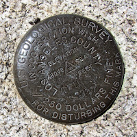
. A party of several hikers are there enjoying themselves.
11:17 - My group leaves the peak so I scrabble off the rock to catch up with them. They head east on the short-cut route that we skipped earlier. I follow but can’t seem to catch up while taking pictures and chatting with hikers coming up the trail. There are some splendid rock formations.

I wish I had some more time for exploring. This route is more of a use path and is much steeper than the circuitous route we took coming, but it’s good and the most direct route to the summit. Seven minutes delivers me to the trail junction. I see no trace of my friends ahead. I pass through the broad saddle and as the trail veers northeast to skirt highpoint 7910’, I’m tempted to climb it. It’s a gentle summit and I could probably descend the other side to rejoin the trail. What they hey, I’m going for it.
It’s a short climb to the first hip but the highpoint is further. Another couple minutes get me to what I think is the highpoint, but there is another outcropping a little further. En route there is a county survey marker dated 1954.
 11:42 – Summit 7910’.
 A pile of boulders marks the spot. The views are obscured by trees. I’d like to linger but two minutes is all this peak will get from me today. I leave the summit continuing west. It’s not unreasonably steep and there are no hindering obstructions. I see some hikers passing by up ahead and I’m a little surprised to reach the trail so quickly…less than three minutes and about 110 feet vertical loss. Now back on the trail I can make good time to catch up with the group.
11:53 - Junction with Twin Peaks Trail. I move quickly but still am enjoying the wonderful scenery. I get to the long switchbacks and see my group down below. With some speed I catch up with Marcia and Lisa (aka “Ketchup”) at 12:02 at the saddle just below the switchbacks. Over my shoulder, the broad mass of summit 7910’ looks really high above us, but I have descended nearly 500 feet. I’m enjoying the views in a different light. To the north, Will Thrall Peak and Pallett Mt. call to me.
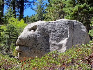
12:15 - Ridgeline trail junction. I get my last peek south and take a couple minutes to check out the upper ski lift terminus of the Buckhorn Ski and Snowboard Club. Down the trail I go. It’s such beautiful scenery. I keep my eyes open for another large rock with a face, which I’ve been told is along this stretch. I missed it on the way up. At 12:27 I’m happy to find Ray and several others lingering at the rock to make sure I didn’t miss it. It’s quite an interesting granite boulder and I can definitely see a face in it.
We continue down trail and Ray points out another interesting rock that looks similar to a turtle or snake head. At 12:40 we cross the dirt road. I turn right on the road to check out the distance…it’s 143 steps to the gate at Hwy 2. Across the street is the entrance to Buckhorn Day Use Area. I walk up the road about 200 feet to the cars.
12:45 - End hike. The total round trip was about 6 miles with 1,400 feet in elevation gain.
Epilog - What an enjoyable and satisfying hike. I had forgotten how beautiful this area is. Great weather, blue skies, superb trail, majestic forest, wonderful scenery, commanding vistas, some adventure, and good company. I am always so thankful for the health and opportunity to recreate in these magnificent mountains.
 Visit Dan's Hiking Pages


 not realizing it would be the only blooming plant I’d notice all day.


 Immediately beyond is a trail split. To the left is a direct route to the summit. We take the route on the right which takes us in about 7 minutes to a junction at the north side of the summit. There used to be a sign here but now it’s just a post. The topography is gentle and accented with large boulders and stately pines. The wide path straight ahead leads to a tangle of roads and ski runs. We turn left (south) and begin our easy accent to the summit. As we near the broad ridge we veer left. I’m looking for Giant’s Head Rock, which Ray says is along this stretch. I miss it so Ray points it out. I guess I can see a face formed in the huge granite boulder gazing into the southern sky with squinting eyes.

 The views here are not stellar because of the trees. The plan is to hike down to the lookout point to the south. So down we climb.
  It’s about 100 yards and 100 vertical feet to a gentle saddle then a stone’s throw to the outcropping. We scramble up the huge boulder pile.


 . A party of several hikers are there enjoying themselves.
 I wish I had some more time for exploring. This route is more of a use path and is much steeper than the circuitous route we took coming, but it’s good and the most direct route to the summit. Seven minutes delivers me to the trail junction. I see no trace of my friends ahead. I pass through the broad saddle and as the trail veers northeast to skirt highpoint 7910’, I’m tempted to climb it. It’s a gentle summit and I could probably descend the other side to rejoin the trail. What they hey, I’m going for it.


