Showing posts with label Angeles Crest Highway. Show all posts

Saturday, August 23, 2014

Waterman Mountain Hike - August 23, 2014

View east from the outcropping lookout point south of Waterman Mountain’s 8034-foot summit. Dominic
Visit Dan's Hiking Pages

The sprawling mass of 8,000-foot Waterman Mountain dominates the San Gabriels middle high country. The scenery is simply magnificent. The forest is rich and mature. The quintessential footpath offers one of the best hikes in the Angeles National Forest. The promises of this grand mountain must have been quite alluring to me—it was the first big summit in the San Gabriels I climbed after buying John Robinson’s Trails of the Angeles. But that ascent was 13 years ago so it’s time for a revisit.

Hikemasters group ready to hike Waterman Trail
When I got word that my friend Ray and his Hikemasters hiking group had scheduled a hike to Waterman, I was compelled to join them. I enjoyed my hike with them to Kratka Ridge in June, so a hike to Waterman provides an opportunity to return to the area. We rendezvous at 7 a.m. on Saturday morning at the Highway 2 meeting location in La Canada. After driving about 34 miles up Angeles Crest Highway we arrive at the trailhead at highway marker 58.00, just shy of the Buckhorn Day Use Area.

View northeast from Mt. Waterman Trail
8:15 a.m. - Begin hike. The weather is beautiful. After briefly paralleling the highway, the narrow footpath crosses a dirt road and heads south. The 11 of us snake our way up the mountain through a splendid forest of Jeffery and sugar pine, white fir, and incense cedar. This is a superb trail. There is a real feeling of wilderness here. Striking views open up to the northwest. I snap a shot of California fuchsia California fuchsia in bloom on Mt. Waterman Trail not realizing it would be the only blooming plant I’d notice all day.

View south into San Gabriel Wilderness from the ridge en route to Waterman Mountain
Thirty minutes delivers us to the ridgeline trail junction with our first views south into the rugged San Gabriel Wilderness. After a 10-minute break we continue west up the trail, which stays north of the ridgeline. I’m loving the fresh air and beautiful scenery. We are afforded views south a couple times before the trail begins several long switchbacks.

On Mt. Waterman Trail heading to the summit
9:37 - Junction. I am the last to arrive along with Lisa, whose nickname is Ketchup. There used to be a trail sign here but now it’s gone. The last time I was here was July 2007 with the San Gabriel Mountains Trailbuilders on a two-day project to remove deadfalls on Twin Peaks Saddle Trail between here and Three Points…so we continued west on the trail. Today we’ll turn right (northeast). After another 10-minute break we continue our accent. The handsome forest is delightful. The trail circles around highpoint 7910 and I ponder if it would make a nice side jaunt. Across the small canyon north I see the upper terminus of ski lift 3. Boulders near the summit of Waterman come into view west.

Broad saddle along the ridge en route to Waterman Mountain
A broad saddle greets us beyond highpoint 7910. In granite boulders, Ray shows us some mortar holes created by the indigenous Shoshonean peoples of centuries past. Looking at Native America mortar holes en route to Waterman Mountain Immediately beyond is a trail split. To the left is a direct route to the summit. We take the route on the right which takes us in about 7 minutes to a junction at the north side of the summit. There used to be a sign here but now it’s just a post. The topography is gentle and accented with large boulders and stately pines. The wide path straight ahead leads to a tangle of roads and ski runs. We turn left (south) and begin our easy accent to the summit. As we near the broad ridge we veer left. I’m looking for Giant’s Head Rock, which Ray says is along this stretch. I miss it so Ray points it out. I guess I can see a face formed in the huge granite boulder gazing into the southern sky with squinting eyes. Giant Head Rock near the summit of Waterman Mountain

Looking east from Waterman Mountain summit (8036’). The survey marker is on top of this boulder.
10:25 - Waterman Mountain (8036’). Jumbles of boulders are scattered around the whole area and it’s not readily clear where the actual high point is. I look around briefly while we wait for everyone to arrive. I recognize the rock where I sat 13 years ago and had my picture taken. Dan Simpson on top of Waterman Mountain summit (8036’), August 25, 2001 The views here are not stellar because of the trees. The plan is to hike down to the lookout point to the south. So down we climb. Descending south from Waterman Mountain summit to the outcropping lookout point It’s about 100 yards and 100 vertical feet to a gentle saddle then a stone’s throw to the outcropping. We scramble up the huge boulder pile. Climbing the outcropping lookout point south of Waterman Mountain summit

View southwest from the outcropping lookout point south of Waterman Mountain summit
The views are fantastic. This is indeed the place to enjoy Waterman Mountain. I join Dominic in climbing to a small flat spot on a large boulder. Wow! This is the sweet spot...unobscured 360-degree view. Twin Peaks dominates the southern horizon. Waterman dominates the north. To the east, Islip and Hawkins ridges stir found memories of some great adventures. To the west is a striking picture of the 2009 Station Fire’s massive devastation. What used to be a blanket of deep green topography is now thousands of acres of tan bareness. Beyond the mountains, thick haze obscures the human sprawl.

View north at the group on top of the outcropping lookout point south of Waterman Mountain summit - Weiwei, Sammy, Rita, Howard, Dan, Dominic. Photo by James
Everyone seems to be enjoying themselves. The group starts to head back at about 11:00. I could easily stay here an hour. I linger for a little longer to savor this amazing location. I head back up the slope to join the others on Waterman’s summit. I climb up on the rock where I sat 13 years ago and have Rita snap my picture. And while here I discover that this is where the survey benchmark is Survey marker on top of Waterman Mountain summit (8036). A party of several hikers are there enjoying themselves.
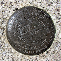
Heading east leaving Waterman Mountain summit
11:17 - My group leaves the peak so I scrabble off the rock to catch up with them. They head east on the short-cut route that we skipped earlier. I follow but can’t seem to catch up while taking pictures and chatting with hikers coming up the trail. There are some splendid rock formations. Granite outcropping along the ridge east of Waterman Mountain summit I wish I had some more time for exploring. This route is more of a use path and is much steeper than the circuitous route we took coming, but it’s good and the most direct route to the summit. Seven minutes delivers me to the trail junction. I see no trace of my friends ahead. I pass through the broad saddle and as the trail veers northeast to skirt highpoint 7910’, I’m tempted to climb it. It’s a gentle summit and I could probably descend the other side to rejoin the trail. What they hey, I’m going for it.

It’s a short climb to the first hip but the highpoint is further. Another couple minutes get me to what I think is the highpoint, but there is another outcropping a little further. En route there is a county survey marker dated 1954. Survey marker near high point 7910 east of Waterman Mountain summit

View east from high point 7910 east of Waterman Mountain summit
11:42 – Summit 7910’. A pile of boulders marks the spot. The views are obscured by trees. I’d like to linger but two minutes is all this peak will get from me today. I leave the summit continuing west. It’s not unreasonably steep and there are no hindering obstructions. I see some hikers passing by up ahead and I’m a little surprised to reach the trail so quickly…less than three minutes and about 110 feet vertical loss. Now back on the trail I can make good time to catch up with the group.

Marcia and Lisa descending Mt. Waterman Trail
11:53 - Junction with Twin Peaks Trail. I move quickly but still am enjoying the wonderful scenery. I get to the long switchbacks and see my group down below. With some speed I catch up with Marcia and Lisa (aka “Ketchup”) at 12:02 at the saddle just below the switchbacks. Over my shoulder, the broad mass of summit 7910’ looks really high above us, but I have descended nearly 500 feet. I’m enjoying the views in a different light. To the north, Will Thrall Peak and Pallett Mt. call to me.
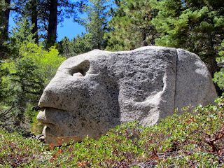
Face in rock on Mt. Waterman Trail
12:15 - Ridgeline trail junction. I get my last peek south and take a couple minutes to check out the upper ski lift terminus of the Buckhorn Ski and Snowboard Club. Down the trail I go. It’s such beautiful scenery. I keep my eyes open for another large rock with a face, which I’ve been told is along this stretch. I missed it on the way up. At 12:27 I’m happy to find Ray and several others lingering at the rock to make sure I didn’t miss it. It’s quite an interesting granite boulder and I can definitely see a face in it.

Buckhorn Day Use Area sign on Angeles Crest Highway, Hwy 2
We continue down trail and Ray points out another interesting rock that looks similar to a turtle or snake head. At 12:40 we cross the dirt road. I turn right on the road to check out the distance…it’s 143 steps to the gate at Hwy 2. Across the street is the entrance to Buckhorn Day Use Area. I walk up the road about 200 feet to the cars.

12:45 - End hike. The total round trip was about 6 miles with 1,400 feet in elevation gain.

Epilog - What an enjoyable and satisfying hike. I had forgotten how beautiful this area is. Great weather, blue skies, superb trail, majestic forest, wonderful scenery, commanding vistas, some adventure, and good company. I am always so thankful for the health and opportunity to recreate in these magnificent mountains. icon

Visit Dan's Hiking Pages

Saturday, June 14, 2014

Kratka Ridge Hike - June 14, 2014

See Dan's Hiking Pages

This is a splendid peak which commands a magnificent panorama over the heart of the San Gabriels Mountains. Unfortunately it eludes most people’s radar because it is a fairly short hike (a whopping 1.5 miles round trip) and conquering a “ridge” does not have much appeal to those who want to bag peaks. And the term “Kratka Ridge” is somewhat ambiguous. On one hand it labels an east-west ridgeline which defines the northern border of the San Gabriel Wilderness and the rugged Bear Creek watershed. And it is close to and roughly parallels the Angeles Crest Highway, so casual sightseers can easily access the ridge crest from several spots along the highway.

On the other hand, “Kratka Ridge” is used to label the 7515-foot peak along the ridgeline. The Sierra Club’s Angeles Chapter, Hundred Peaks Section (HPS) has a list of 275 named summits in Southern California of at least 5,000 feet in elevation. Kratka Ridge peak is on that list. And since I have a goal to climb all of the HPS peaks in the San Gabriels, Kratka has been on my list.

I connected with my friend Ray and he planned the outing with his Hikemasters hiking group. There are nine of us for today’s hike…the same number we had when we bagged Winston Peak, Buckhorn Peak (aka Mount Akawie), and Mount Lewis back in September. We rendezvous at 7:15 on Saturday morning at the Highway 2 meeting location in La Canada. We drive 35.5 miles up Angeles Crest Highway to the old to Vista Picnic Area (highway marker 60.54), which is about 2.3 miles past the entrance to Buckhorn campground. Ray had dubbed me as the leader, so as a disclaimer, I make sure everyone knows that this was my first time on this trail…blind leading the blind.

8:30 a.m. - Begin hike. The weather is beautiful, but a little nippy. The group wonders why I’m the only one not wearing long sleeves. I figure once we get climbing in the sun, I’ll be quite comfortable. We stroll up the path under a rich canopy of pine and fir, and in about 150 years reach a saddle on Kratka Ridge with a superb view down into Bear Creek and beyond. The distant valleys are covered with a layer of June gloom.

After a few minutes of enjoying the view, we turn right (west) and begin to follow the well-defined route up the ridge. Now I’m glad I’m not wearing long sleeves. Soon the route veers right and follows an old service road along the flank of a highpoint on the ridge. Intermittent views through the trees give us glimpses to the north toward Mt. Williamson, Pallet Mt., and Will Thrall Peak. The massive Williams Rock, which in the past, would be swarming with rock climbers, stands in solitude, thanks to a yellow-legged frog. It troubles me that a frog is given priority over the rights of people to recreate in the national forest. Our pace is relaxed as we stop to look at pine cones and snow plants and just enjoy the beauty of this splendid high-country forest.

We reach a slight saddle on the hip of an ascending/descending ridge. We are now on the western perimeter of the old Kratka Ridge ski area. There’s an outcropping on the right so we take a short side jaunt to see what views it offers. Back on the trail comes the fun part. The route turns left (south) and steeply climbs the ascending/descending ridge. It’s really steep, but thankfully it takes only about five minutes of climbing to reach another old service road. We veer right (southwest) and in another ten minutes arrive at a saddle on the ridgeline offering more great views south.

After lingering for a few minutes soaking in the scene, I decide to turn left (east) and climb to a summit of 7400+ feet. It’s only about 100 feet lower than our destination so I figure it would be a good side trip. Most of the group follows. The summit has a lot of trees so it does not offer the kind of views I had hoped for, but still it is a rewarding climb with some nice vistas between the trees. We head back down to the saddle and join up with the others.

From the saddle we climb the wide ski road west. In about five minutes we reach the upper terminus of chair lift. This now-closed ski resort played an important part of the Southern California ski industry. Lynn Newcomb Sr. started Mt. Waterman ski area in 1939 with a single rope two. Three years later, Newcomb built the first chairlift in SoCal at Waterman. In 1954, Newcomb opened the Kratka Ridge ski area just two miles east with a single chair lift…60 years ago. In 1999, both ski areas were sold to a new owner and renamed Angeles Crest Resorts. Efforts to revive the resorts failed. The last known year of operation for Kratka Ridge was spring 2001, and Mt. Waterman February 2002. (Source: Southern California Lost Ski Areas by Eric Gieszl)

We explore around the old bullwheel facility. Weather-worn single chairs hang ghost-like from the cables. There is a lot of history here.

From the backside of the bullwheel facility, a distinct path heads up the ridge. We follow this path about 200 yards to our destination.

10:00 - Kratka Ridge summit (7515’). Wow, this exceeds my expectations! An unobscured 180-degree panorama south stretches from Mt. Williamson in the east to Mt. Waterman in the west, with the vast San Gabriel Wilderness below our feet. Dozens of named peaks punctuate the topography. Distant haze blankets the vast human sprawl of the L.A. Basin beyond the mountains. Saddleback in South Orange County pokes above the marine layer. The weather is perfect. The sky above is deep blue. I love the vanilla scent of Jeffery pine. Directly across the northwest fork of Bear Creek, Triplet Rock (6151’) stands culminating the ragged ridgeline descending east from Twin Peaks East Peak and is perhaps the most inaccessible point in the San Gabriels.

Everyone in the group seems pleased with this lofty destination. We pose for a group picture and enjoy the scenery. As the group starts back I linger to take a few pics and shoot a panoramic video with no voices. Soon I hear the group chanting my name from the ridge below, suggesting that it’s time for me to join them.

10:20 - Leave summit. Soon I join that group as they have a snack in a shaded flat area near the ski building. A weather-worn picnic table has seen better days. A nice thing about hiking with a group is swapping stories and enjoying good conversation. I take pictures of yerba santa and penstemon, some of the few species of flowers in bloom today. We retrace our steps down the mountain. I lead from the rear. It’s such a beautify day with splendid scenery.

11:07 - End hike. We say our good-byes and pile into the cars. It was not a long hike by any stretch of the imagination. The hike is listed at 1.5 miles round trip with 700 in elevation gain. With our side excursion to summit 7400+, our hike was just under 2 miles round trip with about 775 feet in elevation gain.

Epilog - What a fun and rewarding outing! Magnificent scenery, gorgeous weather, blue skies, majestic forest, commanding vistas, good company, and crossing another peak off my list. Life is good! icon

See Dan's Hiking Pages

Saturday, September 28, 2013

Peak Bagging: Winston, Buckhorn, Lewis - Sept. 28, 2013

View southwest toward Mt. Baden-Powell and Mt Burnham from Mt. Lewis
See Dan's Hiking Pages

I’ve always been drawn to climb peaks. While I’m not a peak bagging fanatic, I do keep track of the peaks I climb and have some modest goals. The Sierra Club’s Angeles Chapter, Hundred Peaks Section (HPS) has a list of 275 named summits in Southern California of at least 5,000 feet in elevation. The consuming task of completing the list has no draw for me, but I would like to complete 100, including all of those in the San Gabriels.

So today’s outing was specifically to bag three peaks along the Angeles Crest Highway in the San Gabriels high country: Winston Peak (7502’), Buckhorn Peak (aka Mount Akawie) (7283’), and Mount Lewis (8396’). All three are short hikes of 1.0 to 1.25 miles round trip with 400-500 feet in elevation gain each. The summits don’t compare to other peaks in the area offering grand views and requiring lengthy hikes to get there. I have, however, seen each of these peaks from various perspectives on various hikes and have been drawn to their summits.

Hikemasters group ready to hike
I connected with my friend Ray and he planned the outing with his Hikemasters hiking group. Nine of us rendezvous at 7:30 on Saturday morning at the Highway 2 meeting location in La Canada. We drive 32 miles up Angeles Crest Highway to Cloudburst Summit (7018’) in the Mt. Waterman/Buckhorn area. This is a location where the Pacific Crest Trail crosses the highway. Our trail to Winston Peak starts off as an abandoned dirt road to the left of 3N02.

Climbing north on the ridge to Winston Peak
8:30 a.m. - Begin first hike. The weather is perfect; it’s a gorgeous day in the San Gabriel Mountains! Two minutes up the old dirt road brings us to a footpath veering off to the left to bypass a loop in the road. In another minute we cross the old road which heads west and we continue on the path up the broad ridge. The forest is open and dominated by Jeffery pine. There is nothing in bloom except some rabbit brush. Granite boulders from small to large dot the landscape. Our pace is relaxed and the rate of climb is quite comfortable. Views toward Mt. Williamson open up to our east while Waterman Mountain looms to our south.

View northwest toward the Mojave Desert from Winston Peak
9:06 - Winston Peak (7502’). The broad, tree-covered summit has several large outcroppings. We hang around a stand of rocks on the north edge and enjoy some views toward the vast Mojave Desert. A few of us wander north down the ridge to other outcroppings and are rewarded with some much better views. I eyeball Pleasant View Ridge, Will Thrall Peak, and Pallett Mt. as destinations for future trips. It’s peacefully quite here. Everyone seems to be enjoying themselves. I don’t see a peak register anywhere. I’m not sure if I’m not looking hard enough or if there is none.

I’m the last to leave the summit at 9:54. We retrace our steps back, enjoying the beautiful high country. Looking east across the canyon, I eyeball Buckhorn Peak 1.1 miles away as the crow flies...our next destination.

10:13 - End our first hike (1.25 miles r.t. / 500’ gain). What a fun excursion! After a quick snack, we pile into the cars and drive up the highway 0.5 mile to a wide turnout on the north side of the street just short of mile marker 57.72. Our trail to Buckhorn Peak starts off past a locked vehicle gate on an abandoned dirt road heading north.

Climbing north en route to Buckhorn Peak
10:25 - Begin second hike. The old road ascends at a pleasant grade and bends around northeast. I love the beauty of this forest. Pine, fir, and cedar rise into sky. Scrub oak and manzanita provide of some texture. The sun feels good. The weather is perfect. Our pace is relaxed. In 13 minutes we reach a well-beaten path that leaves the old road and cuts left (north) up a draw. The satellite images show that the road continues a little further then circles back to reconnect with the footpath at the ridge line. We opt for the path and turn north. We reach the broad ridge in few minutes and curve east and in another couple minutes reconnect with the old road at a gentle saddle. Glimpses of the desert open up through the trees.

We continue east up the path. Beautiful scenery! Waterman Mountain towers to our south while somewhere below us in the canyon lies Buckhorn Campground. The roar of motorcycles on the highway disrupts the serenity. Back behind us, Winston Peak emerges as a long bulge on the nearby horizon. I’m really enjoying this trail. And it’s good hiking with others; I’m enjoying their company. We approach the summit, which is a wide, flat open space surrounded by trees. Lots of footprints indicate many visitors. An outcropping on the southeast edge appears to be the high point, so that is where I head.

View southeast from Buckhorn Peak
11:08 – Buckhorn Peak (7283’). Ok, this is nice. Trees obscure the views, but there are glimpses of scenery beyond. A ring of epoxy on a boulder suggests that there used to be a survey marker here.

I have grown accustom to the name Buckhorn Peak because it’s the name used on the Tom Harrison Map and has such a natural connection to the local. However, the Sierra Club HPS renamed it Mount Akawie in 1990 after Dick Akawie (1925-89), one of their leaders. It’s great to celebrate and honor those to whom honor is due, and Mr. Akawie seems to be worthy of recognition. But it bugs me that the Sierra Club renames peaks. Just gets too confusing. I guess I’m more of a traditionalist and prefer that geographic names be left alone. I’d say to the HPS, find a peak that doesn’t have a name yet and give it one. By the way, a name for this peak does not appear on the USGS topo map nor is a name listed with the U.S. Board on Geographic Names. So perhaps that fact contributed to the HPS’s assumed liberty in changing the name. Peakbagger.com also uses the Mount Akawie name.

We leave Buckhorn Peak at 11:20 and retrace our steps down, continuing to enjoy the beautiful setting and great weather.

11:40 - End our second hike (1.2 miles r.t. / 400’ gain). That was fun too! We pile into our cars again and continue up the highway 11.5 miles to Dawson Saddle (7901’) (mile maker 69.48). The last time I was here was to climb Throop Peak and beyond. Climbing Lewis Peak will be the steepest of our hikes today, gaining 500 feet in a half mile. Our trail starts just to the left of the maintenance building and heads north.

Climbing the steep section to Mount Lewis
12:17 - Begin third hike. Wow, the trail is crazy steep! This is billy goat stuff! We slowly creep our way up the precipitous slope. One of our group decides to stay behind and skip this peak. The scenery is dramatic. Views open up through the trees toward Mt. Baden-Powell and Mt Burnham to our southeast and toward the desert to the northeast. We stop often on this steep mountainside to catch our breath. Soon the trail mellows some as it ascends the broad ridge.

View northwest from Mount Lewis
12:47 - Mount Lewis (8396’). This certainly has the feel of climbing a mountain. As with our other two peaks today, the broad summit covered with trees offers limited views. A pile of rocks and a log post would seem to be the logical place for a peak register, but there is none. We sit on some logs and have lunch. It’s warmer now but still quite nice. I stroll a little further to see if there is a better vantage point on the northern hip only to find more of the same.

I leave the summit at 1:10 to catch up with the group. Soon I tangent unto a less-traveled route that follows the top of the ridge and I get some views west. I love the magnificent scenery of the high country. As the trail gets crazy steep, I catch up with the group as they carefully negotiate the descent.

View northwest toward Mount Lewis from Dawson Saddle
1:30 - End our third hike (1.0 mile r.t / 500’ gain). That was a lot of fun! We say our goodbyes and head home. Ray and I take the east route through Wrightwood and the Cajon Pass and experience very different scenery.

Epilog - What an enjoyable day! Great company, perfect weather, magnificent scenery, splendid trails, three new peaks, and experiencing my beloved San Gabriels high country from a different perspective. I am always so thankful to live so close to these wonderful mountains and for the health and ability to enjoy the trails. icon

See Dan's Hiking Pages

Related Posts on Dan's Hiking Blog: