 See Mt. Baden-Powell hike report (5-31-04) at Dan's Hiking Pages
What an amazing day of hiking in the San Gabriels’ high country! This time I took the long drive up Angeles Crest Highway with my friend Mark to conquer a couple peaks that I have not had a chance to climb: Throop Peak (9138’) and Mt. Burnham (8997’). And while we were at it, we ended up adding Mt. Baden-Powell (9399’) to cap it off.
Mark and leave my house at about 5:45, head west on the 210 freeway toward La Canada and then north and east on the Angeles Crest Highway. Driving through the Station Fire burn area, I’m greatly saddened to see thousands of acres that were previously magnificent, mature forest, now laid waste. The horrific damage is beyond words.
We arrive at Dawson Saddle (7901’) at about 7:20. The air is brisk. Mark attempts to reach his friend Don who was to meet us here. I survey the trailhead area. We chat with a couple bow hunters. Don’s not coming so we’re ready to hike.
 8:20 AM - Begin hike on Dawson Saddle Trail heading south up the ridge. After a few steep switchbacks I suspect that we are not on the right trial. My suspicions were confirmed in about 10 minutes as we reach a junction with the formal trail coming from the left. Soon the climb mellows as the trail ascends the gentle ridge. The mature forest and wonderful views are incredible. The trail was built by Boy Scouts in the summer of 1982 to commemorate the 75th year of world scouting at the cost of 3540 volunteer hours. I am falling in love with this wonderful trail and find it to be one of the finest in the San Gabriels.
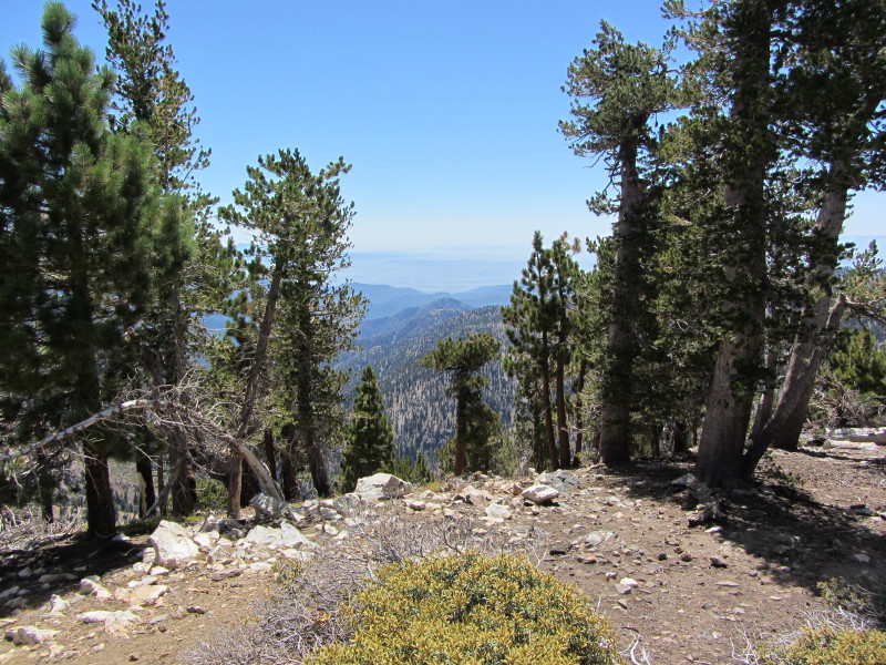
  I really enjoy hiking an ascending ridge like this because of the varying views. Throop Peek looms ahead to the south while Mt. Burnham and Mt. Baden-Powell dominate the ridge to southeast. Windy Gap and Mt. Islip stand nearby to the west while Mt. Wilson country is seen in the distance. To the north Mt. Lewis pokes up while the vast Mojave Desert consumes the horizon. On both sides of the ridge we see the Angeles Crest Highway below as it meanders through the high county. Occasionally we hear a car or motorcycle. After about 1.5 miles the trail bends east across the north face of Throop Peak. A couple ladies pass us.
9:35 - Junction with Pacific Crest Trail (1.8 miles). A sign greets us. A few more steps to the ridge and we look south down into Iron Fork of the San Gabriel River and the vast Sheep Mountain Wilderness. Beyond is Mt. Baldy, Ontario Ridge and the vast human sprawl obscured by a layer of haze. A slight breeze feels good. We hang out here for a while then turn right (west) and follow PCT. In about a minute we reach a “Y” and veer right to follow the use path to the summit.
 10:14 - Throop Peak (9138’). Wow, what a splendid summit! I like it! The scarcity of trees affords great views in most directions. A bronze plaque honors Amos G. Throop, founder of Throop University (now known as Cal Tech). We hang out for a while. A lady arrives at the peak coming from the west. Her name is Debbie and we enjoy talking about hiking. The peak register, housed in a baggy under a small rock, is new and was placed here by Ken Rose. We are the first to sign it. A sailplane glides in the blue sky above. Mt Burnham to the east calls us to proceed.
 11:05 - Leave Throop Peak and retrace our steps east. The sun is warm but the temperature is pleasant. At 11:15 we pass the trial junction for Dawson Saddle Trail and continue east descending on PCT. I’m loving the scenery and wonderful weather. In the distance we watch an LA County sheriff’s helicopter land at Dawson Saddle. Wonder what that’s about. The trail follows closely along the north side of the ridge and provides intermediate views south. As we get closer to the Throop/Burnham saddle, Mt. Burnham looks more imposing. Gnarled and twisted trees speak of harsh winters.
11:52 - Reach the junction west of Burnham (8710’). The Harrison map shows the main trail contouring to the left around the north face of the summit and a secondary trail bearing right and heading straight up the ridge. We choose to veer right and begin the steep ascent. The “trial” soon becomes indistinct but we keep climbing. Meet a young man named Kenny who is out pacing us.
 12:16 - Mt. Burnham (8997’). Nice peak. Views are somewhat obscured by trees. Chat with Kenny. A man and his 15-year-old son arrive with their little dog. We chat. Kenny leaves. Sign the peak registered, which has no protective home except a baggie. Mark and I decide that we have plenty of hike in us so we continue east to conquer Baden-Powell. Leave summit at 12:48.
12:53 - Reach junction with PCT on east side of Burnham (8900’). That route on the east flank of Burnham would definitely be the easier way to reach the top, but we don’t regret our adventure climb up the west side. Stop and chat with the two ladies we saw earlier. Soon the trail approaches a nameless bump on the ridge (9088’), ascends a switchback on the southern flank, and crosses over to the north side. We opt not to summit the bump as the trail skirts along the north. A prominent ridge descends gently to the north and I ponder cross-country routes. A group of six colorfully glad older hikers approaches from the east. We reach the ridge again and stop for a nutrition break with wonderful views south. Debbie arrives on her way down. We chat. Finish our break and continue and soon the trail traverses below the ridge on the north. I get excited as I see the trail on a spur ridge coming up from Vincent Gap.
 2:11 - Mt. Baden-Powell PCT Junction. Wow, spectacular view down into Mine Gulch and the upper reaches of the East Fork San Gabriel River and beyond to Mt. Baldy! This is some of the most dramatic scenery in the range. The “Wally” Walden Tree, a 1,500 year old limber pine, stands majestically on the ridge. We turn right and head south up the trial and several switchbacks for the final 0.1 mile to the summit.
 2:22 - Mt. Baden-Powell (9399’). This peak stands as one of the truly grand summits of the San Gabriels. Years ago this bald peak was known as North Baldy. In 1931 the mountain was renamed in honor of Lord Baden-Powell, the founder of boy scouting.
 There are about 15 people on the summit, including a group of 5 (Nick and family from Commerce), who we enjoyed visiting with. It’s a little warm but a gentle breeze feels great. I have cell reception to call my wife but can’t connect to the Internet to upload to Facebook. I soak in the spectacular views. The 360-dregee panorama includes the vast Mojave Desert to the North, the vast Pacific Ocean to the south, and the rugged San Gabriel Mountains in between. The human sprawl is muted by haze, giving an ethereal sense of being away from it all. I am delighted we made the choice to press onto this superb peak. I was here 7 years ago, but it is certainly worth visiting more often.

Troop Peak and Mt. Burnham
 3:31 - Leave Baden-Powell. Retrace our steps back. When we reach the east slope of the bump between Baden-Powell and Burnham, Mark continues down the trail and I decide to conquer this peaklet (9088’). Three minutes is all it takes to reach its summit. The west slope is steeper and rockier but soon I reconnect with Mark. When we reach the junction at the east side of Burnham we stay right and follow PCT around the north flank and reach the junction west of Burnham at 4:36. I enjoy taking pictures in completely different lighting than this morning. The trail is gentle here along the ridge but soon begins the ascent toward Throop Peak, our final climb of the day.
 5:22 - Junction with Dawson Saddle Trail. Now just 1.8 miles of a pleasant downhill walk to go. I savor how enjoyable this hike has been. Part of me is somewhat tired from a long day of hiking, but part of me is sad to see such a splendid outing come to an end. As we get near Dawson Saddle we stay on the main trail (the portion we missed this morning) and observe that it is a much more desirable route than the old trail section we took this morning. It hits the highway about 250 yards east of the maintenance building.
 6:20 - Done...exactly 10 hours from the start. I scout around the trailhead area to collect good notes for my hike description.
 Epilog - What a thoroughly enjoyable hike on some of the finest trails and in some of the most incredible scenery the San Gabriel Mountains have to offer! The weather was absolutely perfect and the foot traffic was surprisingly thin for Labor Day weekend. Visiting two new peaks was a treat and climbing Baden-Power is always rewarding. I always value Mark’s companionship and glean from his years of hiking experience. And we had lots of nice conversations with other hikers along the way. Mark and I were probably the slowest hikers on the trial today, but no one enjoyed it more than we did. I’ve long touted the trail to Baden-Powell as my favorite in the San Gabriels, and now I can include the trails coming from the west. On the other hand, Mt. Baldy is a great summit, but I’ve always lamented that one can’t get there without hiking on dirt roads or scrambling up crazy steep use paths. The quintessential trails to Baden-Powell are a hiker’s delight. Today we covered 9.3 miles and climbed 2,530 in elevation gain...a most respectable outing. I am so thankful for the opportunity to hike.
See Mt. Baden-Powell hike report (5-31-04) at Dan's Hiking Pages
Wow, sounds like a good hike! I'm just not in shape to go hiking for 10 hours!
ReplyDeleteYep, another amazing hike. Congrats. Looks like it was unusually clear on your hike.
ReplyDeleteHey, Joseph, keep in mind that several hours of that was sitting around enjoying the scenery. :-)
ReplyDeleteThanks, SkyHiker...the visibility in the surrounding mountains was very good. Hazy in the valleys below.
I'm still not in shape for it though... ...I was able to do this: http://josephshikes.blogspot.com/2011/08/desert-view-via-mt-baldy-road.html but don't think I could have made it to the top of old baldy.
ReplyDeleteBTW you have a great website and it's what started me hiking in socal.
I did this same hike on the same day you did. I have a photo at the PCT and Dawson Saddle trail with you in the background. There was another man standing at the junction. What a great ridge trail from Hawkins to Baden Powell.
ReplyDeleteHi, Dan... you had a great day on the Throop to BadenPowell hike. I live in Washington State now and I miss the San Gabriels. I hiked the range for over 55 years and have multiple climbs of all major peaks above 5500 ft.--except Iron, Ross and Rattlesnake. What I regret most is not summiting Iron; I've only gotten to about 6500 ft on it. Thanks again for posting. I can be reached at rmac10@comcast.net if you'd like to chat more. Best, Michael
ReplyDelete