
The availably of the car and a short day at work afforded me the opportunity for my first hike in Griffith Park for the year. And in keeping with my practice of not repeating hikes in the park, I chose a route starting in Brush Canyon then following some use paths I’ve not hiked before. My goal is to hit Mt. Bell and Mt. Chapel, and if time permits, Mt. Lee. My previous hike in Brush Canyon was to Mt. Bell and back, so this outing should offer a different experience.
I leave my office in Echo Park and navigate the 101 to Frankin Avenue and head north on Bronson and Canyon. There is one space left in the small parking lot that holds 14 cars. I’m running later than I had hoped so I might have to adjust my plans.
4:06 pm - Begin hike. Pass the locked vehicle gate and begin walking north on the broad road. The sun is warm. I awoke this morning to a thick marine layer, so I knew it would create less-than-ideal hiking continues with hazy views. We’ve not had much rain this season, so the hillsides are browning sooner than usual. Majestic sycamores and oaks grace the canyon bottom on the right. Soon Mt. Bell comes into view at the head of the canyon. At four minutes in, I pass a dam on the right and the junction for my return route on the left. I’ve climbed it once but have never come down it.

The trail (a wide dirt road) crosses the dry creek to the east side of the canyon. There are others on the trail but it doesn’t feel crowded. It doesn’t seem like there is much in bloom, with mustard as the dominate flower. As the trail bends north, the Hollywood sign begins to peak over the west ridge and is muted by haze. Soon Mt. Chapel dominates the ridge on the north at the head of the canyon. This area has not burned in many years, so the vegetation is mature, thick, and richly textured.

At 4:29 I reach a bend in the road that crosses a wide ravine from the east. This will be my route. Previously I’ve seen a path from the top heading down and in my studies of the aerials, there seems to be an established route, although much of it is not seen in the aerials. Now that I’ve hiked all of the major trail systems in the park, I’m starting to explore some of the informal use paths. I begin to climb up the dry creek bed through a tunnel of brush. It’s no wonder the route was hidden from the satellites. I encounter stinging nettle and poison oak and am thankful I’m wear long pants. Soon the path leaves the creek bed and climbs along the north bank. The massive outcropping comes into view up ahead. The trail gets dicey as it drops back toward the creek to put me at the base of the rock. As the route climbs around to left of the rock, it gets steep, slippery, and quite precarious. I would not recommend this route, particularly for the inexperienced and/or faint of heart. I reach the top of the giant granite outcrop at 5:02. I could have cut at least 10 minutes from this route if hadn’t been stopping to photograph plants.

Now I cross the paved Mt. Hollywood Drive to find my next use path as a short short-cut up to 3-Mile Trail. It’s crazy steep and loose. I use all fours to carefully scale the bank to 3-Mile Trail. Not a good route, and probably worse going down. Now I cross the dirt road to find my next use trail climbing east. The path is well beaten. Soon I climb a steep, slippery section using all fours in places. The route mellows and follows an ascending ridge. Portions of the path suggest that some formal trail construction in the past was used. After another steep, slipper section, the trail bends north and finally arrives at the ridge road that spans Mt. Hollywood and Baby Bell at 5:26. Wow, that was some kind of a climb! I don’t know if that is much of a short cut considering the labor and risk. Probably better to just use 3-Mile Trail.

The view east toward Glendale and beyond elicits a Wow! There is a cool breeze. Below, Bee Rock and Beacon Hill stand in the late afternoon sun and remind me of my visit to them back in November. At this point the plan was to turn north and head toward Mt. Bell. But Mt. Hollywood calls to me from the south. I figure it won’t take long to visit the most popular peak in the park, and I’ll be able to chalk up climbing Mt. Hollywood from Brush Canyon. I turn south and follow the wide road at an earnest pace. As I approach the summit, a car drives by on its way to the top. That’s cheating! Who drives up here?! As the car passes I look inside and recognize that it is L.A. City Councilmember Tom LaBonge! There is also a yellow pick-up truck at the summit.
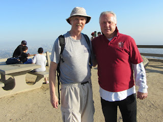 5:36 – Mt. Hollywood (1625’).
 I introduce myself to Mr. LaBonge and thank him for all his work on Griffith Park, which is the crown of his Fourth District. Two city workers are there getting ready to do some painting. Mr. LaBonge grabs a roller and begins to help repainting a steel poll to cover up graffiti. It’s good to see our city officials getting their hands dirty in the field. I learn that his office has a Community Beautification Team of three employees who do various tasks of physical labor around the district. I ask Mr. LaBonge about the lack of trail signs around the park and he says it’s primarily because of graffiti and vandalism. But he says they are looking at funding for signs.
I linger on the peak for a while. I love this place. There are several others here enjoying the destination as well. The view south over L.A. is muted with haze. The parking lot of the observatory below is full. The sun sits low on the western horizon.
5:50 - Leave the summit and retrace my steps. I pass the use path junction at 5:56, which means that the side jaunt to Mt. Hollywood cost me 30 minutes. I continue north and climb the south ridge to the next summit.
6:01 - Baby Bell. This is a well-placed little peak with a commanding view. It’s not formally named but I call it Baby Bell because of its close proximity to the taller Mt. Bell to its northwest. A young lady arrives at the peak. We chat as we walk down the northwest ridge to road. We part ways and I begin a quick scramble up Mt. Bell from its east approach. It takes only three minutes, which I suspect is a record for me.
6:16 - Mt. Bell (1582’). If number of visits is an indicator of favorites, this would be my favorite peak in Griffith Park. Its central location makes it accessible from any approach around the park. I post a picture to Facebook. I ponder the time with just about an hour till sunset (7:22). Since they lock the gate to the parking lot at sunset, it’s imperative that I manage my time.
6:23 - Leave Mt. Bell using the southwest approach. The trail is in good condition but is a little slippery in places. I reach Mt. Hollywood Drive at 6:34 and am confronted with a decision. Do I play it safe and return via Mulholland Trail and Brush Canyon, or continue the loop descending Hollyridge? Daring soul that I am, I opt to continue, but to skip summiting Mt. Chapel.

I continue west on the dirt road that heads to the water tank on the north flank of Mt. Chapel, then soon cut left to the narrow trail that traverses the south flank of Chapel. It’s really quite a decent trail and deserves to be on Tom LaBonge’s map. But alas, it’s on mine! I move quickly. I have a splendid view down into the heart of Brush Canyon and the route I climbed. I pass Mt. Chapel and continue west along Mulholland Ridge with views both toward the San Fernando Valley on the north and the L.A. skyline on the south. It’s cool enough now to warrant putting on long sleeves, but I don’t want to take the time. I pass a monitoring station along the path that has a sensor and cameras. A flash goes off. Are they taking my picture?! There’s a tag that says “United States Department of the Interior.” I don’t take the time to read it but take a picture to read it later. It says “The National Park Service is conducting a study to better understand and project the wildlife community in the area.” Hmmm, I’d prefer the Feds not mess with our city park.

6:52 - Junction to descend ridge (shy of Mt. Lee Road by about 100 yards). I have exactly 30 minutes to sunset. I’ve got to keep moving quickly. I really dislike forced time constraints. I turn south and begin descending the use path along the narrow ridge. I ascended this route for the first time in February 2012 and found it to be a nice alternate from the wide roads. This will be my first time to descend it. The trail is literally in a deep rut for most of the way…kind of strange. Mt. Lee to the west is now in silhouette as the late afternoon sun rests on the highpoints to the east. I see walkers on the trails below. I pass over Mulholland Trail and keep descending the ridge. I look at my watch often.

7:03 - Hollyridge Trail. I now have 19 minutes to sunset. Feels good to be on a graded road for couple minutes. Past the stables, I reach the junction for the route dropping into Brush Canyon. I turn east and begin descending the ridge. This section isn’t bad. I have to watch carefully for the spur trail junction so I don’t miss it and end up in unknown territory. I reach the junction at 7:10. Now the tough part! I am a little concerned because I know that the path drops straight down the mountainside and is steep and slippery. I juggle quickness and carefulness as I negotiate the steep path. I dislike racing the clock, but there is some excitement to it. Between my vigilance and God’s grace, I descend successfully.
7:16 - Brush Canon Trail. Wow, I made it! That was an adventure. My adrenaline is still pumping as I walk the final few minutes back to the car.
7:19 - End hike…3 minutes shy of sunset! I jump into the car and race to the gate. I exit the gate at 7:23 and take another pic of the sign that says gate closes at sunset. The park ranger is not here to lock the gate, so I guess I had more time. But there is no way of knowing! Once I saw a park ranger just waiting at the gate near sunset. So it’s better to be safe than sorry.
Epilog - Another enjoyable adventure in my beloved Griffith Park! Springtime is the very best season to experience the natural beauty of this natural treasure. The web of trails—formal and informal—provide so many different options. It could be years before I have to repeat a hike. And it was a treat to run into Councilman LaBonge and to see his crew working to beautify our park.
 See Hiking Griffith Park at Dan's Hiking Pages
 (includes links to my other blog posts for hiking in Griffith Park)
NEXT > Mt. Chapel, Mt. Lee, and Cahuenga Peak - April 18, 2013
PREVIOUS > Beacon Hill, Glendale Peak and Bee Rock - Nov, 21, 2012


 The trail (a wide dirt road) crosses the dry creek to the east side of the canyon. There are others on the trail but it doesn’t feel crowded. It doesn’t seem like there is much in bloom, with mustard as the dominate flower. As the trail bends north, the Hollywood sign begins to peak over the west ridge and is muted by haze. Soon Mt. Chapel dominates the ridge on the north at the head of the canyon. This area has not burned in many years, so the vegetation is mature, thick, and richly textured.


 5:36 – Mt. Hollywood (1625’). I introduce myself to Mr. LaBonge and thank him for all his work on Griffith Park, which is the crown of his Fourth District. Two city workers are there getting ready to do some painting. Mr. LaBonge grabs a roller and begins to help repainting a steel poll to cover up graffiti. It’s good to see our city officials getting their hands dirty in the field. I learn that his office has a Community Beautification Team of three employees who do various tasks of physical labor around the district. I ask Mr. LaBonge about the lack of trail signs around the park and he says it’s primarily because of graffiti and vandalism. But he says they are looking at funding for signs.


The more LaBonge does for Griffith Park, the more I like him. A few weeks ago, he secured enough money to let the Observatory open on Tuesdays, again. :D
ReplyDeleteI passed a wildlife monitor near Hellman Park in the Puente Hills. That one mentioned lynx and cougar. Given the confirmed cougar sighting in Griffith Park earlier in the year, I'd bet money this is the same thing: Trying to figure out how many lynx and cougars are living in our local hills, and where they travel.
Awesome website and great information...
ReplyDeletehttp://thruhikepct.blogspot.com