
I guess the Griffith Park hiking bug bit me. I really enjoyed my hike last week, yet was disappointed by the hazy visibility. So with the availability of the car, and beautiful, clear skies, I had to go back. And I decided to hit Brush Canyon again. Last week I headed to the peaks on the east: Mt. Hollywood, Baby Bell, and Mt. Bell. So this time I decided to hit the peaks to the west: Mt. Chapel, Mt. Lee, and Cahuenga Peak. And in keeping with my practice, this is not a route I’ve combined together before.
I leave my office in Echo Park and navigate the 101 to Frankin Avenue and head north on Bronson Avenue and Canyon Drive. Like last week, there is only one space left in the small parking lot that holds 14 cars.
3:15 PM - Begin hike (50 minutes earlier than last week). Pass the locked vehicle gate and begin walking north on the broad road. Soon I am stopped briefly by a small video crew shooting on the road in the shade of a majestic oak. I’m alert to things I missed last week. It’s much warmer today. As I pass the dam on the right, I plan to scout out a use path that heads northwest to the ridge. From the aerials, it appears that it might be a better route to access the west ridge than the steep path I came down last week, directly across from the dam. I stroll up the path a short distance but the route seems to deteriorate. I’ll have to check it out sometime (maybe on my return trip). Back on the road, I continue up canyon. There is a fair amount of foot traffic today.

As the trail begins climbing the canyon’s east slope, the city below begins to emerge over my shoulder though the narrow canyon mouth. I’m a particularly keeping an eye on the canyon bottom and dense forest and the possibility of exploration in the further.
At about a half hour (0.8 mile), I pass the junction where the use path heads east up the ravine to the huge outcropping, the route I hiked last week. I continue along the road as it begins to contour west. I really enjoy the good visibility and the splendid scenery. I’ve not been concerned about capturing the plants in bloom. I reach an outward bend and am rewarded with a great view south into the canyon and beyond.

4:00 - Junction with Mulholland Trail. Now it’s time for a new route. From the aerials I noticed a route the seems pretty clear from this location up to the east ridge trail to Mt. Chapel. The path starts about 75 yards west from the junction of Mulholland Trail. I am pleasantly surprised how nice the route is. It’s a little brushy and steep in places, but not bad at all. In just six minutes I successful arrive at the trail junction, about 100 yards west of Mt. Hollywood Drive. That’s a good short-cut providing a more direct route to Mt. Chapel from Brush Canyon. I like it! I turn left (west) and begin to climb the ridge toward Mt. Chapel. Last week it was nearly sunset as I walked this trail, but today I have lots of sun and great visibility. In a few minutes I reach a split. To the left is the route I took last week that traverses the south flank of Mt. Chapel. I stay straight and head to the top. Soon it gets really steep and requires all fours. I’ve been down this route a couple times, but this is my first time up it. It’s a great climber’s path.
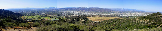
4:24 - Mt. Chapel (1614’). Wow, I love this peak! The views are so good today. Mt. Lee and Cahuenga Peak dominate the west. Mt. Bell, Baby Bell, and Mt. Hollywood dominate the east. The San Fernando Valley spreads out to the north. Beyond the expansive parklands to the south, downtown L.A., Hollywood, and a vast human sprawl lies before me. I can see all the way out to Catalina Island. The breeze is cool on my sweaty body. Others arrive at the summit and continue on their way. A father and son—David and Benjamin from Iowa—reach the top. I give them directions to Mt. Lee and point out some of the surrounding landmarks.

I leave Mt. Chapel at 5:03 and head down the southwest ridge. This is a good route but a couple steep, rocky sections require vigilance. Another hiker passes me on this way to the top. I think this is the busiest I’ve experienced it on Mt. Chapel. Typically I have it all to myself. In twelve minutes I reach the junction with the trail coming from the east across the south flank of Chapel. Now I’m retracing my steps from last week as I stroll along Mulholland Ridge with great views to the north and south. I’m enjoy and sun and excellent visibility. I pass the junction of the ridge route I took last week in my hurried decent to beat sunset. Another 100 yards delivers me to Mt. Lee Road at 5:25.

The road has been recently repaved. There are a lot others enjoying the walk. Dave and Benjamin pass me heading down. It’s warm now as the road slices along the north side of the mountain which blocks the refreshing breeze. I reach the hairpin turn at 5:38 and get my first look at the monument that was
dedicated on March 22, 2012. The bronze plaque celebrates the decade-long effort to purchase Cahuenga Peak to protect the land from development and add it to Griffith Park.
5:42 - Mt. Lee (1680’). Wow, this is always a treat. Below me stands the iconic HOLLYWOOD sign and looking better than ever after its new paint job last year. I snap some pictures then climb to the very top for more scenery. Hiking here on a clear day is so much better than when haze chokes the visibility. There are others coming and going. I don’t linger because I decide I still have time to hit Cahuenga Peak. Leave peak at 5:56.
I retrace my steps back to the new Cahuenga Peak monument and head west on the narrow trail. In the photos for the dedication event, there is a
nice sign for Aileen Getty Ridge Trail, but now the sign is gone. I follow the rustic path as it traverses the undulating ridgeline. There are places where Aileen needs to do some maintenance on her trail. As I cross the saddle, Cahuenga Peak stands as a towering mass before me. The route gets steep requiring hands and feet in some spots. Soon I pass to the north side of the mountain and enjoy some richer vegetation for the final pitch to the summit.
6:14 - Cahuenga Peak (1820’). This peak dwarfs all else on the east end of the Santa Monicas. I wander around the summit to experience the sweeping views of the massive human sprawl. The rugged solitude of this lofty perch creates a sense of transcendence while the subtle din is an ever-present reminder of the vast metropolis that surrounds. I could spend a long time up here, but the dipping sun and the threat of a locked gate compel me down.

I leave the summit at 6:25 and retrace my step east on Aileen Getty Ridge Trail. The warm light of the setting sun invites photography. Reach Mt. Lee Road at 5:43 and continue down. At the junction with Mulholland Ridge Trail (6:53), I continue south down the road rather than taking the ridge route I descended last week. I figure it would give me a chance to compare times. At 6:59 I transition unto Mulholland Trail heading east and at 7:07 turn hard right onto Hollyridge Trail. At 7:11 I reach the ridge route junction coming straight down from Mulholland Ridge. It took 18 minutes coming down the road. Last week it took 11 minutes coming down the ridge. So that shortcut saves 7 minutes.

I walk past Sunset Ranch stables and in a few minutes veer left unto the ridge to drop me back down into Brush Canyon. Shortly I decide to take the path that appears to be the upper end of the route I explored at the beginning of the hike. But quickly the route becomes steep and precarious with no sign of a clear route down. I abort that effort. It’s too close to sunset and a locked gate to be thrashing through brush on a steep mountainside. Back on the ridge, I continue down the beaten path. When I get to the junction last week’s return route, I decide to skip it and continue south down the ridge. Soon it gets steeper and just short of the campground, it bends east and drops steeply into the canyon, reaching the road at the location of the fenced utility bunker. Another minute delivers me to my car.
7:34 - End hike. It’s now 7 minutes past sunset, so I hope that they don’t lock the gate promptly at sunset. My car is the only one left in the lot. I jump into the car and race to the gate. I’m elated to find it still open.
Epilog - Another enjoyable adventure in my beloved Griffith Park! Warm sun, cool breeze, excellent visibility, pleasing scenery, three peaks, wildflowers, new routes, good exercise—what a splendid hike!
 See Hiking Griffith Park at Dan's Hiking Pages
 (includes links to my other blog posts for hiking in Griffith Park)
 Brush Canyon to Mt. Bell hike description at Dan's Hiking Pages
(Detailed trail guide with options to Mt. Hollywood, Mt. Chapel, Mt. Lee, and Bronson Caves)
 See blog post: Chapel, Bell, Hollywood, and Bronson in Griffith Park
 - February 24, 2012 (via Hollyridge Trail trailhead)
NEXT > Griffith Park Hike: The Los Angeles Zoo - May 19, 2019
PREVIOUS > Mt. Hollywood and Mt. Bell - April 12, 2013


Nice write-up. Always get that little extra jolt of energy down the mountain when you feel you may be racing a locked gate!
ReplyDelete