Saturday, August 25, 2012

Mt. Williamson Hike - August 25, 2012

View southwest from Mt. Williamson toward Twin Peaks and Mt. Waterman
Visit Dan's Hiking Pages

What a splendid hike in the San Gabriels’ high country! Mt. Williamson has long been on my list so finally the occasion arose to conquer it. My friend Ray and his Hikemasters group had planned the hike and it worked out to join them.

At 8,214 feet, Mt. Williamson stands by itself north of the Angeles Crest Highway with commanding views over the heart of the San Gabriels and the vast Mojave Desert to the north. It lies within the Pleasant View Ridge Wilderness, which was newly established in 2009 to protect nearly 27,000 acres of pristine forest. Most of the hike travels along the Pacific Crest Trail, one of the quintessential footpaths in the San Gabriels.

We arrive at the trailhead several miles short of Islip Saddle and about 40 miles east of La Canada. Our plan is a loop hike starting on the west approach and ending on the east approach at Islip Saddle, so we staged a couple vehicles there.

Hikemasters group ready to hike Mt. Williamson
8:53 - Begin hike (6700’). There are 8 of us and a dog. The weather is perfect. This section of the PCT heads north and east along the steep southwest slopes of Mt. Williamson through a mature forest. Ray likes this approach because the ascent is primarily in the morning shade. Soon views toward Mt. Williamson open up. It’s quite an impressive mass.

9:18 - Reach a jagged ridge with amazing views south into the heart of Bear Creek canyon and the rugged San Gabriel Wilderness. Cars and motorcycles whisk along the highway below. A car horn honks in the road tunnel shattering the tranquilly of the wilderness. A marine layer blankets the human sprawl beyond the mountains to the south. A series of switchbacks makes our ascent reasonable as we climb the steep mountainside. We cross huge scree slopes. The scent of staghorn lichen brings back childhood memories of building a model train set.

View south from the trail to Mt. Williamson
9:52 - Achieve Williamson’s south ridge and the junction to the summit climb. We linger for a few minutes and enjoy striking views east and south. I look across to Mt. Islip and think about standing on that summit six weeks ago and being drawn to this mountain. The PCT continues east descending toward Islip Saddle, but we turn north on the well-beaten path and are treated with views east and west. Lush green manzanita blankets the ground and sugar pine and white fir reach into the sky. A pleasant breeze feels good. For a few minutes the route is gentle until we reach the section where the climb gets serious. The path snakes up the steep ridge in a Lombard Street manner. The footing is loose. We patiently climb and in about 10 minutes we reach a splendid outcropping as the path mellows out. As we continue along the ridge, the scenery is gorgeous.

10:32 - Pleasant View Ridge. Wow, impressive view northeast to the desert. We turn right (southeast) and another minute brings us to the summit.

View northeast toward the Mojave Desert from the official summit of Mt. Williamson (2814’)
10:34 - Mt. Williamson (8214’), the official summit. The board, bald summit offers commanding views. We linger for a few minutes but the goal of the group is the next knob along the ridge (8244’), 0.3 mile northwest. Many consider that higher point to be the actual summit of Mt. Williamson, and indeed that’s where the summit registry is located. We backtrack a minute to the junction and continue along the ridge. There is some roller coaster action and in several spots the footing is loose and somewhat dicey. A sailplane soars by. I’m loving the beauty of this rugged high country. We make a final climb and a spur path cuts left to the reach the summit.

View south from the middle summit of Mt. Williamson (2844’)
10:51 - Mt. Williamson (8244’), the middle summit. I walk around among the trees and rocks to admire the varying vistas. This is a superb peak. Ray serenades us on his ocarina. I flip through the peak registry and notice names of some HPSers I recognize. Mars Bonfire summited this peak for his 24th time on July 5! This is as far as our group will go today, so I decide to continue along the ridge to hit the third highpoint. Ray says to meet the group back at the junction by 12 p.m.

I leave at 11:11 and head northwest along the ridge. More of the same: Fir and sugar pine, manzanita and chinquapin, amazing scenery, craggy rock formations, blue sky, warm sun, pleasant breeze.

View northwest from the northwest summit of Mt. Williamson (8248’) toward Pallet Mt. and Will Thrall Peak
11:20 - Mt. Williamson (8248’), the northwest summit. The small, mostly bare summit provides great views, particularly northward toward the vast desert. From here the ridge steeply drops about 350 vertical feet to a saddle (7900’+) before climbing steeply to the next knob along the ridge (8160’+). Further northwest, Pallet Mt. and Will Thrall Peak stand as twin pyramids and call me to climb them. On the slope facing me to the northeast is debris from a plane wreck. Our ascending route can be seen to the south. Marine layer still hangs over the L.A Basin, so there is no hint of the massive human sprawl and the Pacific Ocean. I would enjoy hanging out here a lot longer, but the clock ticks. I leave the summit at 11:36.

View southeast along Pleasant View Ridge to the middle summit of Mt. Williamson (2844’)
I retrace my steps southeast along the ridge enjoying the scenery from the opposite direction. Stop to change my camera battery (after 254 pics and 7 videos). I arrive back at the middle summit (8244’) at 11:48. My friends have already left so I continue down the trail. As I hurry along I see no sign of them ahead. A lady passes me and I ask her if she saw my group and she says about half mile down the trail. That can’t be right. I arrive at the junction at 12:02, just two minutes late, and the group is not here. I continue down wondering why the group left me.

View east from PCT toward Mt. Lewis
12:18 - PCT Junction. No one is here. I had really expected them to be here. I turn left (east) and begin my descent. Whenever I’m on the Pacific Crest Trail, I’m aware that this iconic path stretches all the way from Mexico to Canada. The dense blossoms of rabbit brush add a nice splash of yellow. The route descends a huge bowl with views east. Over my shoulder, the mass of Mt. Williamson looms above. The topography is breathtaking. I’m enjoying the solitude but wonder where my group is. Looking across to Mt. Islip, Throop Peak, Mt. Burnham, and Mt. Baden-Powell brings happy memories of most excellent adventures. I’ve still to conquer Mt. Lewis and Mt. Hawkins, so I’ve been eyeing them all day with hopes of hitting them this season. Soon the Islip Saddle trailhead can be seen on the highway far below.

View southeast from PCT toward Mt. Islip
As the trail bends southwest I’m intrigued by a pointed summit (7103’) at the bend of the highway; maybe next time I’ll hit it. A couple ladies pass me going up...the only humans I’ve encountered since the summit. The disparity in traffic distribution between marquee destinations like Baldy, Baden-Powell, and Icehouse, and less-visited peaks like Mt. Williamson is striking. And that’s fine by me; I like sitting on a superb peak all by myself! I pass a saddle offering a good view west and I begin my final southeast stretch toward the finish.

View southeast toward Islip Saddle trailhead from PCT
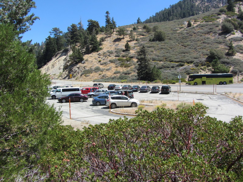
1:17 - Islip Saddle (6670’). Done. There are about 25 cars and a large bus in the parking lot. Obviously most of those hikers headed up toward Little Jimmy, Windy Gap, and Mt. Islip. I was eager as to why the group left me. Ray told me that the dog had gotten sick so they left early to get him back. Ok, I have the dog to thank for an hour and half of solitude!

Epilog - What great hike, one of the finest in the San Gabriels! Covered about 4.5 miles and 1,600 feet in elevation gain. Great weather, blue skies, pleasant breezes, magnificent topography, sweeping panoramas, mature forest, superb trail, good company, and a peak I’ve not visited before all made for a thoroughly enjoyable outing. This is definitely a destination worth repeating. icon

Visit Dan's Hiking Pages
 

Saturday, August 4, 2012

Fish Canyon Falls Hike - August 4, 2012

Fish Canyon Falls
See Fish Canyon Falls Hike Description at Dan's Hiking Pages

I had never hiked Fish Canyon in August—for good reason—summer is not the ideal time to be hiking the front of the San Gabriels, particularly in a location where water is supposed to be the highlight. But Vulcan Materials put the date on their access days calendar to provide free shuttle rides through the quarry to the trail. My suggestion to Vulcan was to concentrate more of the access days in the spring when the conditions are outstanding. But they spread the days out into the summer months with August 8 being the last date for the year. So with limited time for hiking this weekend and the absence of motorized wheels, at the last minute I decided to go. It was more out of curiosity. I really didn’t suspect many people would show up.

I jump on my bicycle at about 9 a.m. for the 20-minute ride to the Vulcan Materials site at the month of Fish Canyon. To my surprise there is a long line of cars. I ride to the front and the guard says they have already reached 500 and are letting people in only as people are leaving. Thankfully I have to wait only a couple minutes. I chain up my bike, jump in a van, and two minutes later I’m at the trailhead ready to begin.

Weedy conditions on Fish Canyon Trail
9:30 - Begin hike. As I stroll up the trial I’m not surprised to see dry, dead grasses and weedy plants. It’s such a very different look than the lush, green beauty of springtime. A light marine layer is burning off to hazy sun. Thankfully the temperature is unseasonably mild. Nothing is no bloom expect for California buckwheat and a few occurrences of cliff aster and chicoryleaf wirelettuce. As I look beyond the immediate weediness I appreciate the rugged beauty of this canyon.

Some of the 650 hikers on Fish Canyon Trail
Streams of people are coming back down the trail. It is crazy crowded. For the entire trip I was never out of earshot of voices, some quite ruckus. There is water in parts of the creek, but it’s not really flowing. Beyond the weeds, the deciduous trees, such as white alder and bigleaf maple, are in full leaf. The tree of heaven jungle really feels like a jungle. Poison oak is beginning to turn its fall colors.

I am pleasantly surprised to see a flow of water at Darlin’ Donna Falls. As I arrive at the creek crossing, I find it strange to see it bone dry. I meet a gentleman named Bob Jones (no relationship to the university). We chat as we continue up the trail together. Still streams of people leaving. I figured since we’ve seen hundreds leave the falls, there would not be many people there. I was wrong. As we approach the falls, there is not the sound of flowing water, just a cacophony of human voices and the splashes of kids throwing large rocks into the lower pool.

Fish Canyon Falls, not flowing
10:35 - Fish Canyon Falls. Tons of people! What an unlikely place for so many people to be in August! I’m honestly puzzled as to why the crowd. Perhaps many people really don’t have a sense for the seasonal variations of the San Gabriels. Maybe they are thinking it’s summer, so that means beaches, lakes, rivers, and waterfalls. But with a reasonably small drainage area and low rainfall totals, Fish Canyon Falls today is a big dry rock with crusty moss.

Crowd at Fish Canyon Falls
At any rate, most people seem to be having a good time. This is Bob’s first time here and he is really enjoying the beauty of the canyon. I stand on a dry rock in the middle pool and the waterline comes to my waste. A snake slithers through the water. Some guys are jumping into the lower pool, which seems a little risky since the water level is so low. I visit with Chris and Mei, whom I’ve met on previous hikes here.

Fish Canyon Trail
12:25 - Leave the falls. Crowds are thinned out a little. Temps are warmer but not bad. Stop to see the rare Dudleya densiflora (San Gabriel Mountains liveforever) but it’s past its bloom. I point some gals to Darlin’ Donna so they can say they saw a waterfall. The warm sun brings out the aroma of California bay. The agave (century plant) sports a handsome bloom. A bee seeks pollen from the yellow prickly pear blossom. A few yellow flowers linger on a lone canyon dudleya growing out of a rock. Noisy voices are a constant reminder of the large numbers today.

1:25 - Done. A couple dozen people are waiting for the shuttle.

View south on Fish Canyon Trail toward the Vulcan quarry
Epilog - It was a good outing. Now I can say I’ve hiked to Fish Canyon Falls in every month except for October and December. I enjoyed meeting various ones who recognized me from my website and were kind enough to introduce themselves: Sue, Kumar, Lee, Bob, Anuk and Dee, and Vince. And it was nice to see Chris and Mei again. The Vulcan supervisor said they had more than 650 for the day, which rivals the biggest days on the books. It’s still puzzling to me why so many people showed up in August. Perhaps they thought that since it was on Vulcan’s access day calendar, it would still be in a good season to hike. Be as it may, it’s great to see so many out hiking! icon

See Fish Canyon Falls Hike Description at Dan's Hiking Pages

NEXT > Fish Canyon Falls Hike - April 6, 2013
PREVIOUS > Fish Canyon Falls Hike - May 5, 2012

Sun icon It's Summertime!
Here are some suggestions for excellent summer and early fall hikes:

Sunday, July 15, 2012

Mt. Islip from Crystal Lake Hike - July 15, 2012

It’s summertime and that means hiking the San Gabriels high country. It’s been some years since I’ve hiked Islip Ridge Trail from Crystal Lake to the Big Cienega Trail junction, so that was my choice. My only reluctance was that I would not be attaining a peak. But the breathtaking scenery should be plenty rewarding.

In September 2002, the Curve Fire destroyed more than 20,000 acres of the Angeles National Forest, including much of the Crystal Lake basin. The following year I hooked up with the San Gabriel Mountains Trailbuilders, who had special access to the Crystal Lake area to restore trails. For eight years until 2011 when the area was finally reopened, I worked on trails with the Trailbuilders and watched the area slowly recover. The hard part was working on trails that people didn’t have access to use. So today I get to enjoy benefits of a trail that the Trailbuilders worked so hard on for years to maintain awaiting for reopening.

I arise at 5:20 a.m. and leave my home in Azusa at 6:27. After a 40-minute drive on Highway 39 up San Gabriel Canyon, I arrive at the entrance to the Crystal Lake Recreation Area. I turn right and another 1.2 miles brings me to a left turn on the lake road and then another 0.2 mile to the small parking lot. There are two cars here and another pulled in a minute after me. The sun is rising over Hawkins Ridge. The trail starts at the south end of the parking lot, but it’s not evident and there is no sign. It’s a pleasant 54 degrees.

7:15 - Begin hike (5575’). Within a minute a large wooden sign announces, “Islip Ridge Trail, built and maintained by the San Gabriel Mountains Trailbuilders in partnership with the U.S. Forest Service.” This portion of the trial leading up to the ridge is sometimes referred to as Wawona Cut-off.

The trail gently climbs south through what feels more like chaparral than a pine forest. There are some pine and fir still living, but many are just blackened sticks. A couple spots provide access and glimpses down to the lake. I have memories of pulling yerba santa from the trail. The trial climbs at a comfortable rate. Views of the basin open up. Far to the south Saddleback pokes through the hazy marine layer. Feels warm now in the open sun.

7:38 - Reach a spur ridge which is the farthest point south for the trail. The route turns west then north as it continues its climb through undulating terrain accented with huge boulders. A motorcycle can be heard on Hwy. 39 far below.

One of the hallmarks of the San Gabriel Mountain Trailbuilders is its expertise in building stone features like retaining walls and steps. Islip Ridge Trail is a good showcase for that handiwork. Unfortunately during 2007, while the Trailbuilders were pinned down replacing a bridge with gabion baskets in Icehouse Canyon, the Forest Service hired a trail contractor who installed a bunch of ugly, unnecessary Sutter walls along this trail, destroying its hand-built feel.

8:07 - The trail finally achieves the main backbone of Islip Ridge and the land of living trees. The panorama to the west features the rugged expanse of San Gabriel Wilderness dominated by Twin Peaks and Mount Waterman. A strong, cool breeze feels good. I’ve really been enjoying the total solitude. My pace is relaxed as I gently ascend the board ridge. The sky is deep blue and the air fresh. I love the vanilla smell of Jeffery pine. I stroll through intermittent patches of shade and open sun. The breeze is unrelenting. The trail stays mostly to the east side of the ridge as it circumvents a steep section.

8:29 - Arrive at the bench. There were four of these splendid log benches placed along the trail at strategic locations as an Eagle Scout project led by Mylan Draganov. This bench is the only one that survived the 2002 Curve Fire. It provides a nice view of the lake if you sit up tall.

8:48 - 2-mile post. Another 15 minutes delivers me to the main ridge again with more spectacular views west. I hang out here for a bit, explore and just soak in the scenery. There is hardly anything in bloom: a few occurrences of yerba santa, lupine, California fuchsia, poodle-dog bush, bush monkeyflower, mountain lilac, southern mountain woolstar, volcanic gilia, alpine sulphur-flowered buckwheat, milkweed. The trial stays mostly on the east side of the ridge but occasionally it crests with views east. I’m loving the beautiful and solitude.

9:58 - 3 mile post. It doesn’t take a mathematician to see that at near 2 hours and 45 minutes to get to here is pretty slow, but I love just sauntering along and experiencing the amazing setting...varied topographic, sweeping views, majestic trees, warm sun, cool breeze, blue sky, and serenity. As I look far to the west, San Gabriel Peak and its neighbors stand silhouetted and remind me of my splendid outing last November.

After a while the trail disappears and I have to do some route finding. It’s pretty easy since it’s just a matter of following the broad ridge up. I see a bushy gray tail disappear behind a bush. I assume it’s a squirrel, but as the creature emerges I see it’s a fox. Wow, what a treat! This is only the second or third fox I’ve seen in my years of hiking in the San Gabriels. He poses long enough for a photo.

Still off trail, I come across some scat from either deer or bighorn sheep. I saw a couple deer earlier, but I also know that bighorn sheep have been spotted in this area. I continue looking for the trail when all of a sudden a herd of Nelson bighorn sheep scatter in a flurry right in front of me! As these majestic animals frantically disperse, I’m conflicted as to where to point my camera. How do I capture it? I got several shots off and some video. There were 20 to 30 bighorns, including a bunch of young ones. What a special experience!


I proceed slowly, still in awe of what I just experienced. I’m still off trail as I climb to a high spot 7600+. The ridge drops to a broad saddle and I tangent east and find the trail again. Another 100 yards brings me to the junction.

11:09 - Big Cienega Trail junction (7580’). This was to be my destination at 3.9 miles and 2,100 feet in elevation gain. But I’m still feeling good and the sign says it’s only 0.9 miles to Mt. Islip. Oh, let’s do this. I’ve never hiked to Mt. Islip from this approach, so it will be good. I continue along the broad ridge heading north.

11:18 - 4-mile post. I came down this route last July and returned via Big Cienega Trail, so the terrain is more familiar now. Thousands of dead trees testify to the destruction of the 2002 Curve Fire. But the scenery, however, is breathtaking and even the lifeless tree trunks rising into the sky add to the beauty. My pace is still relaxed as I enjoy the solitude. In fact, it’s almost lonely here. Many millions in Los Angeles, and I’m the only one on this ridge in this magnificent high county on this gorgeous day. What a gift!!

Fractured rocks, big and small, adorn the landscape. Fresh sawdust indicates recent work to remove deadfalls from the trail. The ridge narrows and Mount Islip stands majestically in front of me. A string of motorcycles looks like tiny ants on the Angeles Crest Highway. The trail gets steeper as it curves northeast, leaving the ridge and cutting across the flank of Mt. Islip.

11:57 - Trail junction coming up from Windy Gap. I turn left (west) and in a few minutes reach the ridge where the trail switches back. I decide to go straight up the ridge. It’s steep but quite doable. I had contemplated exploring this route the last time I was here.

12:06 - Mount Islip (8250’). Humans! There are 11 of them in two parties. I don’t know why, but I always feel a little emotional when I arrive on a peak, even one I’ve climbed multiply times. There is something special about being on a mountaintop. I love this peak, and perfect weather allows a stunning panorama. The peak register has disappeared. I enjoy chatting with some of the folks. It is a pleasure to meet and chat with Luis, his wife Nina, and his sister, Tricksie, all from Azusa...practically my neighbors! Solitude is great, but sharing a mountaintop experience with others is good too. Everyone leaves and I have a few moments by myself.

Leave summit at 1:20 and head down the trail for a pleasant descent, The breeze is still strong. I reach Windy Gap (7588’) at 1:54. A man and woman are just leaving, heading down Windy Gap Trial. It’s windy here, as usual, but it’s been windy all day. There has been recent activity here in carving log benches. After a few minutes I head down Windy Gap Trail south into the Crystal Lake Basin. A little warm now. Still spectacular scenery. I am appreciating the efforts of the Trailbuilders in removing the deadfalls along this trail. I counted 19 last July. Today I encounter just one.

2:57 - South Hawkins Road. This is where I encountered the bear last July. Instead of continue on the trail, I turn right (west) toward Deer Flat. My pace is fast now as I’m eager to be done. At Dear Flat I cut through campsite 1 and find Lost Ridge Trail. It’s been a few years since I’ve worked on this trail with the Trailbuilders. It’s in decent shape but doesn’t get much traffic. I pass a young couple heading up the trail. It’s amazing to me that aside from the people at Mt. Islip summit and Windy Gap, I’ve had the entire day to myself until now. In fact, today I’ve seen more bighorn sheep than people!!

3:47 - Lake Trail junction (not marked). I turn right (southwest) and eight minutes gets me to the big parking lot above the lake. The F.S. and volunteers have done a great job of restoring the area. I climb down the rock steps to the lake and look around. A few people are here. It’s hot. The water is low and a leafy, green water plant around the edges gives the lake a swamp feel and smell. Another five minutes up the road and down to the small parking lot completes the loop.

4:15 - End hike. Wow, nine hours exactly from the start! That’s a lot of time for a 10-mile hike with 2,750 feet in elevation gain. But how thoroughly enjoyable! The car thermometer says 90 degrees, which might be a little high since the car has been sitting in the hot sun.

Epilog - What a great hike! Ideal weather, blue skies, warm sunshine, blissful solitude, remarkable animal encounters, spectacular scenery, breathtaking vistas, splendid trails...for the San Gabriels, it doesn’t get much better than this! Part of me wants to announce to the world to come and enjoy this wonderful Crystal Lake Basin. But another part of me wants to protect the solitude. I’ve definitely got to return soon! icon

See slide show of a Trailbuilders workday on lower Islip Ridge Trail - July 17, 2004

See Windy Gap Trail hike description at Dan's Hiking Pages

See Mt. Islip hike description at Dan's Hiking Pages

See Big Cienenga Trail hike description at Dan's Hiking Pages