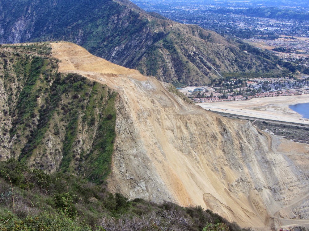
This trail is at risk to be forgotten and abandoned, but it indeed offers a vigorous workout, solitude, rugged chaparral, and a splendid ridgeline with grand views. The trail is the third section of the old Fish Canyon access trail that climbed high up over Van Tassel Ridge to circumvent the quarry operation in the mouth of the canyon before dropping a 1,100 feet back to the historic Fish Canyon Trail. When Vulcan Materials opened the new access trail through the quarry in June 2014, the first two segments of the old access trail over the ridge were closed. But the third section is still intact and begs to be used. Read my
Van Tassel Ridge Hike Description at Dan's Hiking Pages.
When I
hiked the trail in July, one month after the grand opening of the new access trail, I was pleased that the trail was still passible, although rough and brushy. Fast forward to Friday, March 13: I did a
plants hike to Fish Canyon Falls with Michael Charters. When we passed the junction to Van Tassel Ridge Trail, I was saddened that the trail looked virtually ignored. When I woke up on Sunday morning I spontaneously decided revisit the trail. I knew that temps were forecast for the 90s, but I figured I’d be up and down before the major heat.
After a short drive from my house in Azusa, I arrive at the trailhead and count about 21 cars in the parking lot. It’s 71 degrees. The sunshine is somewhat hazy.
8:25 - Begin Hike. This is my sixth time on the new access trail since it opened on June 21. Almost immediately I encounter a giant blazing star in bloom on the berm. It was not blooming Friday. I wonder if this is one of the plants that was included in the hydroseed mix when they built the trail.
8:41 - Cross the bridge into the national forest and in five minutes arrive at the junction to Van Tassel Ridge Trail. It’s barely noticeable as a trail.

I begin my climb. I’m wearing long pants because I know it’s going to be brushy. Good choice. Most of the plants on the trail are the soft weedy grasses. Some parts of the trail look pretty good and others are cloaked in vegetation and virtually invisible but easily passible.

Much of the trail is in good shape.
|

Wadding through this is not as bad as it looks.
|
The surrounds are lush and jungle-like compared to the dead and parched foliage in July. Plants in bloom are many of what we saw on Friday: Blue dicks, hollyleaf cherry, miner’s lettuce, chickweed, wild cucumber, common eucrypta, turkey pea, sticky monkeyflower, mustard, wishbone bush, California thistle, pipestems, elderberry. There is also black sage and California everlasting, which I didn’t recall seeing in bloom on Friday. (
See plant gallery below .) Poison oak is abundant and I must vigilantly dodge it.

The trail is steep and I’m working up a good sweat. I’m thankful that light clouds are helping keep the temps down. Nasty bugs are tormenting me but I’m too lazy to dig to the bottom of my pack to get repellent from my emergency kit. I put a sprig of sagebrush on my hat and that seems to help. As the trail zig-zags up the mountain, it occasionally intersects the ascending/descending ridge and offers expanding views of the massive quarry. I’m a little surprised when another hiker shows up. I told him I had honestly thought I’d be the only one on the trail. He vanished up the trail. Mature chaparral blankets the rugged canyon around me. I can see a portion of Fish Canyon Trail far below.


9:40 - Reach the flat clearing and benchmark. After a seven-minute break I continue. Some sections of the trail are crazy steep. I have a good view across the canyon to Fish Ridge where Vulcan is restoring the mountainside. They are sculpturing the sheer rock to conform with the natural topography and carving 12-inch micro benches which will support soil and revegetation.


I reach a fork in the trail that I don’t remember. A right heads up to the ridge (the way on which I will return). Left continues straight contouring to a lower section of the ridge. I stay to the left and in another minute arrive at the ridgeline.
10:24 - Van Tassel Ridge (2080’). A chain-link fence separates the national forest and Vulcan Materials. A temporary fence section spans the bulldozer-size gap that was here in July. Views toward Duarte, Azusa, and the San Gabriel Valley are muted with haze. The green vegetation and wildflowers are a big contrast to the parched conditions in July. In the distant east, the ridgeline from Mount Baldy to Ontario Peak defines the horizon. There is very little snow up there. To the west, Van Tassel Canyon is blanketed in thick, dark green vegetation.


After lingering a few minutes, I head north up the firebreak. I didn’t have time to explore the ridge in July. The last time I hiked beyond this point up the ridge was August 2004. At that time it was pretty brushy and I went only a short distant to highpoint 2364. Today I’m going to take advantage of the firebreak and get a feel for how passible the ridge is. The firebreak was probably recut for the Madre Fire which began on September 2013 in Azusa at the mouth of San Gabriel Canyon. A steep, 3-minute scamper delivers me to a hip where the ascent mellows out. This is where the other trail from the earlier fork arrives. The panorama south is striking.

I continue up the ridge.

The ascent is mild. It’s getting warm but hazy clouds help keep the temps down. Tall lupine is growing like crazy with its showy purple flowering stalks. Mustard, wild morning glory, cliff aster, and a few other flowers announce the soon-arriving springtime. I’m really enjoying the rugged mountains and thick chaparral.
11:05 - Highpoint 2364. What splendid scenery! It’s peaceful here. I’m treated to a sweeping vista from west to south to east. Just beyond the foothills to the south, human habitation sprawls to the hazy horizon. To my immediate north, an imposing prominence along this ridgeline rises 250 feet to a pinnacle. That monster climb screams at me to stop. This is as far as go today. I linger here for 10 minutes then decide to stroll the 150 yards to the base of the monster climb, just for perspective before turning back.

Here at the base I see that the firebreak extends to the top, but it’s crazy steep.

I decide to climb a little to get a nice picture of the ridgeline I climbed. The expanding views are rewarding. I’m really huffing and puffing. And I’m in a lupine jungle. Before long I am about a fourth of the way up. I decide that since I’ve done a fourth, I can do a half. I keep climbing. It’s quite warm and there is not a lick of shade. I creep slowly up. I sit occasionally. I really need to get in better shape. I love the beauty of nature that surrounds me. But I loathe these nasty bugs.
I reach the halfway point and I figure I’ve done half, I can do another. Sheesh, am I really doing this? I keep climbing. The firebreak now cuts below the ridge crest and blocks the breeze that was refreshing me earlier. It gets steeper. I wonder about the footing coming down. There is a fresh set of footprints so I suspect the gentleman who passed me near the beginning of the hike has continued up the ridge since I never saw him return.
12:05 - Pinnacle (2720’+). Wow, I did it! That was really a workout. I am rewarded with breathtaking views. The problem is, there is still another pitch going to a higher point.

I can’t stop here, can I? I drudge on and it takes me 9 minutes to achieve the next highpoint.
12:17 - Highpoint (2800’+). Ok, this is as far as I go, really. From here the recently cut firebreak descends gently along the ridge a couple hundred yards to a slight saddle, climbs briefly, than stops. An old firebreak continues up the ridge to highpoint 3136’.

Part of me would really like to press on further, but I’m hot and tired and ready to be done. I’m eager to sit and eat and head back. Beyond 3126’, the topo map shows an old fire road that curves around to the west and connects with Van Tassel Fire Road and Mt. Bliss (3720’) (See my
Mt. Bliss hike description). I have often pondered a loop hike to Mt. Bliss which would include this route up Van Tassel Ridge. With this reasonably clear firebreak, the route seems very doable [later I got a FB post from hiker Crystal stating that she recently climbed this ridge all the way to Van T Fire Road]. I sit on the berm and have some lunch. Directly below me to the east is Fern Canyon, a tributary to Fish Canyon. When hiking to the falls over the years, I’ve pondered exploring Fern Canyon but figured it would be choked with thick brush. From this vantage point, it looks completely impassible for humans.

12:52 - Begin back. I retrace my steps. Down I go. I pass highpoint 2670’ and the steep section is faster going down than up, but careful steps are required. I slip several times but don’t go down. The wispy clouds help keep temps manageable. It also helps the lighting for photos.

It takes me a half hour to negotiate descending the steep section. It’s easy going now. I find some shade under a laurel sumac and take a 15-minute break. I dig my bug repellent out. I reach the hip above the forest boundary at 1:57 and take the path that was the right fork that I skipped earlier. I hit the trail junction in about a minute. My descent is slow as I take time for plant work and photography. The shade and jungle-like vegetation is welcoming.


As I negotiate the lower switchbacks nearing Fish Canyon Trail, I am startled by an alarming rattling sound in the brush just a few feet above the trail in front of me. It’s a sound that gets the adrenal pumping. It’s a sound that says in no uncertain terms that a venomous pit viper is unhappy with me being there. And he has the ability to inflict great bodily harm upon me. I instantly retreat about six feet. The big rattlesnake continues to rattle as it quickly slithers across the trail. I am able to snap one pic before he disappears down the slope through the thick brush. I hurry past the spot and almost immediately arrive at a switchback, so I have to use a section of trail where the rattlesnake was heading. Thankfully I didn’t encounter him again. Over the years I have occasionally encountered rattlesnakes. In fact, I want to see one once in a while just to remind me that they live here and pose a threat. I have to say, this was probably one of my scariest encounters. Normally, I see the snake first as it’s laying in the trail soaking up the warmth. Well, I guess it is good to be scared once in a while.
3:39 - Arrive at Fish Canyon Trail.

My pace is relaxed as I walk back to the bridge and through the quarry. I’m still thinking about that snake.
3:59 - Finish hike. It’s 93 degrees. There are 19 other cars in the parking lot. (All of them are in the white, black, and silver pallet. We’ve become such an aesthetically boring nation.)
Epilog - What a rewarding adventure. I love the beauty of springtime with its vibrant vegetation and graceful flowers. The heat today was more summerlike than end of winter. I hope we get more rain so that the beauty of springtime doesn’t flee too quickly. And climbing that ridge was a serendipitous adventure indeed. From what I’m hearing, it’s unlikely that the Forest Service will maintain Van Tassel Ridge Trail in its inventory. So it’s up to the hiking community to keep the trail clear with foot traffic.


Giant blazing star
(Mentzelia laevicaulis)
|

Wishbone bush
(Mirabilis laevis)
|

Miner’s lettuce (Claytonia parfoliata)
|

Chickweed (Stellaria media)
|

Common eucrypta
(Eucrypta chrysanthemifolia) |

California everlasting
(Pseudognaphalium californicum)
|

Sticky (bush) monkeyflower
(Mimulus aurantiacus)
|

Pipestems
(Clematis lasiantha)
|

Wild morning glory
(Calystegia macrostegia)
|

Tufted poppy (collarless Calif. poppy)
(Eschscholzia caespitosa)
High on Van Tassel Ridge
|
 See Van Tassel Ridge Hike Description at Dan's Hiking Pages
See Fish Canyon Falls Hike Description at Dan's Hiking Pages
See Van Tassel Ridge Hike Description at Dan's Hiking Pages
See Fish Canyon Falls Hike Description at Dan's Hiking Pages (including a link list for my other blog posts for Fish Canyon)
 Like Fish Canyon San Gabriel Mountains on Facebook
 See Fish Canyon Trial Plant Guide (April 2011) (PDF)
See Plants and Wildflowers in the San Gabriel Mountains at Dan's Hiking Pages
NEXT > Fish Canyon Falls Hike - April 19, 2015
PREVIOUS > Van Tassel Ridge Hike - July 20, 2014
See Fish Canyon Trial Plant Guide (April 2011) (PDF)
See Plants and Wildflowers in the San Gabriel Mountains at Dan's Hiking Pages
NEXT > Fish Canyon Falls Hike - April 19, 2015
PREVIOUS > Van Tassel Ridge Hike - July 20, 2014


 The barren, ashy landscape is surreal. There is almost a beauty to it in a Tim Burton kind of way. The only life is a fresh anthill.
 A lone blossom stalk of a yucca juts into the sky, strangely untouched by the fire.
 As I round the outward bend by the first water tank, the pinkish-red Phos-Chek fire retardant covers the ground. Tons of it was dropped by aircraft during the first day of the fire.
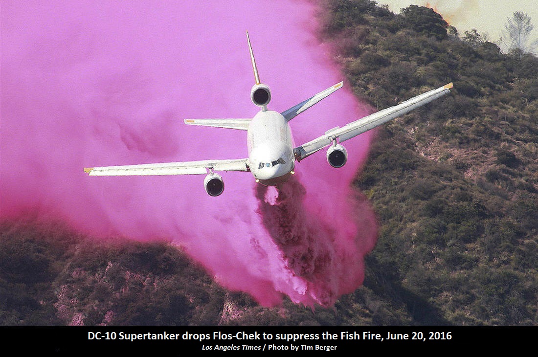 The top of the water tank is now Phos-Chek red.
 Typically much of my attention while hiking is on the plant life and photographing flowers. It’s so bizarre to walk through a lifeless moonscape. The last of the day’s sun lingers on distant Mount Baldy and neighboring peaks to the east. Huge power towers stand gangly against the azure sky.


 The scene is haunting. I should be overwhelmed with sadness over the loss of the rich chaparral that blanketed these slopes. But I feel at peace…kind of a melancholy contentment.
 The last sunlight sits upon Mount Baldy. I decide to continue up a little more. Deep in the canyons below some trees may have survived the inferno. I pass through a section of road that was previously lined with beautiful pines.
 They are dead now.
 I now have a view southwest over the San Gabriel Valley as dusk falls and lights begin to twinkle. An orange band of haze outlines the horizon. It’s peaceful here. I linger for a few minutes and soak in the beauty of nightfall. At 8:15 I head down.
 I’m tempted to tangent up a slope to achieve a summit, but I decide to not trample bare earth by going off trail. As I reach the power towers, I scramble up to the tower on the high point to enjoy the vistas. It’s almost dark now and the human sprawl is a blanket of lights. The ambient light is sufficient for my steps. The temperature is quite pleasant.

 See Mt. Bliss hike photo album - 8-14-11