Today was an amazing trio of experiences! It began with a sunrise hike on Colby Trail—tranquil solitude, beautiful scenery, wildflowers, and the freshness of springtime chaparral. Midday was an urban hike in downtown to L.A. Live and the Staples Center to join thousands of bike racing fans for the culmination of the eight-day, 750-mile, Amgen Tour of California—adrenalin and excitement watching some of the best athletes in world race through the streets of Los Angeles. The day ended with a hike to Griffith Observatory to join thousands of Angelinos in a shared experience viewing a remarkable solar eclipse—the natural beauty of rugged Griffith Park and the celestial phenomenon of the sun and moon. What an experience of many miles under my feet and an array of imagery from the peaceful to the exhilarating to the phenomenal!
My daughter, Christa, who is visiting my oldest daughter Anna in Sonora, Calif., emailed us about a bike race she saw. Stage 4 of the Amgen Tour of California began in Sonora. Christa told us that it would be coming through Azusa on Saturday. My wife and I thought it would be fun to walk the half mile from our house to Sierra Madre Blvd. to watch the cyclists swoosh by. And it was. Then after watching the telecast of the race, I thought it would be fun to see the ending, live. I had also been pondering experiencing the annular solar eclipse from Griffith Observatory. So with the race in the morning and the eclipse in the evening, it seemed ideal to spend a few hours at my office in Echo Park (halfway between downtown and Griffith. But the first order of business for the day was a real hike.
Colby Trail
I rise before the crack of dawn and drive the 10 minutes to trailhead of Colby Trail in Glendora.
5:45 a.m. - Begin hike. It’s a crisp 55 degrees. I stroll up the woodsy path enjoying the quite stillness of the morning. A coyote stops to observe me. Birds sing. The month of May in Glendora means brodiaea time...namely,
Brodiaea filifolia, the endangered thread-leaved brodiaea. My first stop is the brodiaea reserve and I was glad there were at least a few of blooms of the small purple flower amidst a sea of dead grass. I continue up the trail. Glendora and the San Gabriel Valley lay sleeping below me. Marine layer mutes the views. I’m delighted to find a passion flower
(Passiflora spp.) in bloom. Soon the first rays of sun land on the ridges. It’s amazingly peaceful here. There is a lot in bloom but I don’t spend much time in taking pictures. At 6:18 I step into the sun at the junction of Colby-Dalton Trail as the yellow ball of light emerges from the eastern ridgeline.
6:22 - Glendora Mountain Road. I soak in the tranquil beauty as I play some tunes on the ocarina. I reflect on what this spot was like yesterday afternoon as more than a hundred world-class cyclists pedaled their way up this road en route to Mt. Baldy Ski Lifts, a grueling 78.3 miles for the day. After lingering a while I start my descent. At the junction I turn left to take Colby-Dalton Trail. A doe eyes me carefully. I’m still in awe of how peaceful it is. The mature oak forest is lush from the winter and spring rains. Poison oak glistens in the morning sun. After more than a dozen switchbacks I reach the bottom adjacent to the flood control basin in Little Dalton Canyon, now back in the shade.

I turn southward and begin my climb. When I reach the dam I decide to explore off trail and climb up the concrete-gullied ravine on the right. It leads up over the terraced slopes. I spot a couple coyote pups disappear into the brush. The sun feels good. A sea of mustard gives the hillside a yellow hue. I’m really enjoying myself. I reach the berm and begin to descend again. In minutes I’m back at the junction of Colby Trail. I take a side jaunt up to the brodiaea reserve again, now in direct sun, to take a few more photos. I’m sure glad this mesa is natural open space rather than a tract of homes. Thank you endangered
Brodiaea filifolia for standing in the way of “progress!”
|
|
|
Brodiaea Reserve
Glendora |
Thread-leaved brodiaea
Brodiaea filifolia |
Back on the trail I make my final descent under a canopy of oaks. I encounter my first humans of the day...three inconsiderate women with their dogs not on leashes.
8:08 - End hike. The matilija poppies beg to be photographed...I comply. What a thoroughly enjoyable time of solitude and bathing in the natural beauty of this splendid trail and the freshness of a spring morning.
Amgen Bike Race
Now off to my second adventure. I drive home, shower, dress, pack, and am on the I-210 freeway heading west toward LA by 9 a.m. I arrive at my office in Echo Park in about a half hour. Sunset Boulevard is closed for the race. It feels like a ghost town...very eerie. I linger around a while thinking it would be fun to photograph the cyclists racing past my office. But then I decided I had better head downtown to where the real action will be. I get in the car and navigate toward LA Live. I know that with the Kings playoff game, a bike race, and various road closures, it will be best to park at a distance and walk to the epicenter. I find a place to park on Hartford Avenue at 7th Street. It feels like a ghost town here too. I stroll down 7th and a 45-minute “hike” delivers me to Olive Street. I’ve never experienced the heart of our great city being so deserted. It feels kind of like Manhattan in the movie “I Am Legend” with Will Smith.

The riders will peddle around a downtown circuit five times before crossing the finish line for the last time. My excitement builds as I see a cop car coming up the street with lights flashing signaling that the riders are coming. The lead pack whooshes past heading north on Olive. A minute later the rest of the throng passes followed by a caravan of support vehicles. That was a fun blast of excitement.
I cross the street and walk one block to Hill Street to see them on the rebound. Five minutes later, here comes the racers again! Swoosh! I walk four blocks south on Hill to 11th just in time to watch the riders pass again and take a right turn. Now a five-block walk west takes me to 11th and Figueroa where the real action is. A huge crowd, cameras, loud speakers, music, VIP boxes, awards stage, Staples Center, LA Live—what a spectacle! Now this feels like a world-class sporting event!
Excitement builds as the racers approach the finish line heading into their last lap. The cyclists whoosh by at the roar of the crowd. I don’t follow bicycle racing at all, but this is a fun experience. The announcer gives the play by play as the racers pedal through the final lap. Again the excitement builds to a crescendo as riders race to finish Stage 8 and 750 miles at about 11:38. Peter Sagan wins his fifth stage and Robert Gensink finishes as the overall winner.
I stay and watch the awards ceremony then wander around L.A. Live taking in the spectacle. Well, I’m hungry and have I’ve had enough excitement for now. I leave at about 12:15 for a 20-minute hike back to the car.
I drive back to Echo Park, have some lunch, and spend some time working in the office. I know the eclipse starts at 5:24 and ends at 7:42, so I figure I’d leave for Griffith Park about 4:30.
Griffith Park Solar Eclipse

My plan is to park along Ferndale Avenue near Los Feliz Blvd. and hike one of the west approaches to the observatory. But as I turn onto Fern Dell Drive, I see that this is a bad idea. The traffic is at a standstill. Inching along I finally get to Red Oak Drive and see the opportunity to escape the gridlock. I turn left, drive a few blocks, and park in a residential area at 5:15. I walk back to the Ferndell picnic area and begin a pleasant hike. A canopy of mature trees—from oak, sycamore eucalyptus, and even redwood—provides a woodsy feel. Lots of others have the idea too of walking to the observatory. I choose the northern route West Observatory Trail and begin my ascent through the thick chaparral. The wide dirt road is dusty and well traveled. Almost immediately the iconic observatory comes into view high on the mountainside above. Views are muted by haze. As I reach a ridge I look north and see that Western Canyon Road is complete parked with cars from top to bottom. Abundant mustard dominates the floral landscape casting a yellow hue.

As the trail bends southeast, I decide to veer left and take a use path up the ridge. I’m a hiker, I don’t need to stay on a wide dirt road with all the ordinary folks. The route climbs steeply and provides a nice vista north and south. I stop to photograph a beautiful specimen of showy penstemon. It’s 5:39 now and I’m aware that the eclipse has already started. Soon I reach a spur road that runs below the observatory and deadends here. I follow it south, but before I reach the junction I decide to take another use path up the steep hillside. It works nicely and soon I find myself climbing past a splendid stand of matilija poppies to arrive at the observatory’s south lower observation terrace.
5:49 - Griffith Observatory. I get my first view of the eclipse from a man holding a piece of paper with a hole in it casting a blurry crescent-shaped spot of light on the wall. I wander over to the west end of the observatory. The place is a buzz with people using various means to view the solar phenomenon. I step inside the door of the west rotunda and realize I hit the mother load. A small crowd gathers around the monitor of the solar telescope. There on the live screen is the eclipse! A docent describes what is happen. Cameras are clicking and beeping and flashing. There are other viewing devices on both sides of the room offering additional images. I linger for awhile soaking in the experience.
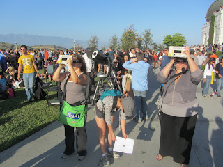
I decide to go outside and explore more. An amazing assortment of people are using all kinds of devises to view the eclipse. To me, the astronomical phenomenon is interesting, but even more so is the human response to it. This place is a people watcher’s gold mine. As I curve around to the front of the observatory I am blown away by a vast sea of several thousand people covering the great lawn. I flit around like a bee trying to capture various images of people interacting with solar event. Long lines wait to view the eclipse through serious telescopes. Shorter lines are cued up for viewing on more modest gadgets. I’m having a blast. In fact I’m deeply moved. I came up here thinking it would be a fun place to see the eclipse, but I did not anticipate how emotionally stirring this shared experience would be.

I watch the delight of children as they form a grid of overlaid fingers to cast a patch of dots on the wall. One guy uses binoculars to project a strikingly clear image of the eclipse. Someone is using something to project a crescent on the shady side off the tubular elevator structure. Some have the cardboard “Solarama” viewers sold by the observatory. One little girl has her head in a box. A welder’s mask is the choice of another. Some are using sunglasses as camera lens filter.
I wander onto the rooftop to get a bird’s eye view of the sea of humanity on the great lawn. At 6:37 a voice comes over the loud speaker announcing that we are about one minute from maximum eclipse. The crowd lets out a cheer. It’s hard to image another place on planet earth better to experience an astronomical event than right here at LA’s historic Griffith Observatory. I go back inside to get another view from the solar telescope.
Then back to the roof. The crowd on the lawn is thinned a bit. I post some photos to FB. Then back to the great lawn and view the solar phenomenon through various devises. I watch Michelle Valles of NBC4 record her tag for her news piece.
Well, I’ve had enough excitement for the day. At 7:26 I leave on the main trial south. Lots of people leaving. I take pictures of the setting sun. I don’t recall if I ever been on a sunrise hike and sunset hike on the same day. I enjoy a pleasant walk down the southern route West Observatory Trail to Fern Dell.
7:50 - End hike at car.
Epilog - What an amazing day! A sunrise hike experiencing solitude and the beauty of nature. An urban hike experiencing a deserted downtown LA and the exhilaration of a world-class sporting event. And a sunset hike to an iconic landmark for a remarkable shared experience with thousands of Angelinos viewing an astronomical phenomenon.

 See Hiking Griffith Park at Dan's Hiking Pages
 (includes links to my other blog posts for hiking in Griffith Park)
 See Colby Trail Hike Description at Dan's Hiking Pages
See Ferndell to Griffith Observatory via West Observatory Trail
COLBY TRAIL:
NEXT > Garcia Trail to Colby Trail Hike – December 31, 2013
PREVIOUS > Colby Trail Hike - April 30, 2011
See Colby Trail Hike Description at Dan's Hiking Pages
See Ferndell to Griffith Observatory via West Observatory Trail
COLBY TRAIL:
NEXT > Garcia Trail to Colby Trail Hike – December 31, 2013
PREVIOUS > Colby Trail Hike - April 30, 2011


Griffith Observatory 75th - May 14, 2010 - Hike from Ferndell and Western Canyon - Photo album with 45 photos with captions


