Since spring is touted to be the very best time for hiking in Joshua Tree, I decided that Easter weekend would be the ideal time to visit my daughter in Twentynine Palms.
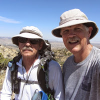
Recently I was contacted by a hiker named Alan who has hiked many of the established trails in JTNP and offered to share advice with me. So in planning the trip, I emailed Alan and he was most helpful in telling me about various trails. I planned on a short hike on Friday afternoon after we arrived, and set aside all day Saturday for a peak. There are nine peaks in JTNP on the Sierra Club Hundred Peaks list (HPS) (above 5,000 feet), and five on the Lower Peaks list. I decided on an HPS summit: Warren Point (AKA Warren Peak) in Black Rock Canyon. And it worked out that Alan was available so we were able to hike together.
I leave the house at sunrise and meet Alan at the Denny’s restaurant in Yucca Valley at 7 a.m. We have breakfast while getting acquainted and reviewing the hike plan. We drive the five miles to Black Rock Campground and park near the visitor center. We gear up and go inside to checkout trail conditions with the park rangers; everything is A-okay.
8:27 AM - Begin hike. We turn left after walking down the visitor center steps and turn left (south) on the first road. We pass by campsites 39 through 29 to campsite 30 where the trail begins at an elevation of 4,071 feet (A). (Note: Each red letter corresponds to GPS coordinates listed below and on the topo map.). The sign reads, “Access to West Side Loop, Panorama Loop, Warren Peak.” We proceed south on the trail which is surrounded by the desert flora. The sun is strong and the temperature pleasant. We continue to get acquainted as we walk the gentle grade. We veer left past the big tan water tank and follow the sign on the right hand side of the dirt service road for “West Side Loop” (B). Bearing right, we continue southeast.
The trail is wide at this point and well traveled. I am impressed with the array of wild flowers and Alan is patient as I stop to photograph samples of each species in bloom. He is veteran hiker with lots of trail lore, but is not much interested in plants. When he encounters a plant, he has only one question: “Does it pose a threat?” That’s a good question indeed. Thankfully there is no poison oak here, but there are lots of plants with sharp things that can puncture passersby.
We reach a Y junction (C).
8:53 - Four-point junction (D). Straight ahead is Burnt Hill Trail (2.5 mi.). Crossing in front of us is Black Rock Canyon Trail. To the left the trail follows the wash back to the campground. We turn right and head southward up canyon. The grade is still gentle. The trail surface is soft sand. It’s quiet and peaceful. The landscape is dominated by gangly Joshua trees amongst various shrubs, cacti, and blooming wildflowers. A couple gals wearing florescent pink and orange shirts pass us heading south;
9:29 - Black Rock Spring (E). A small stagnate puddle of water sits in a rock-rimmed basin at the base of a large black rock. Bees and other flying insects are swarming around. It’s a most unappealing setting and we don’t stop (actually I stopped to take a picture but Alan kept going to avoid the bee hazard). Alan says that the poor condition of this spring is likely due to the drought. A few more minutes delivers us to another Y junction.
9:35 - Panorama Loop Junction, lower (F). Each fork heads up a wash. The sign reads 3.8 miles. But the maps and Alan’s previous GPS track shows it at 2.8. I question the discrepancy. Apparently it’s a typo on the sign. We plan to hike the loop on our return, so we veer right (south). The canyon gets narrower.
9:52 - Panorama Loop Junction, upper (G). It’s marked by dilapidated post which the Park Service has not yet replaced with one of the nice new ones. Left (which is indicated with PL) heads south up a wash and will be our return route. Right (WP) heads west up a wash. This will be our route. The canyon broadens out and soon the pyramid-like summit of Warren Point comes into view to the northwest. It’s striking against the blue sky. Two tiny figures stand on the peak; illuminated by their pink and orange shirts. Our route continues up the wash. Cacti intrigue me; so beautiful but oh so threating!
10:08 - Warren View Junction (marked by a dilapidated post) (H). To the right is Warren Point, our destination, but first we will bear left and continue west up the wash to visit Warren View. It’s getting steeper and warmer. Soon we see two tiny pink and orange sticks descending the trail across the canyon.
10:20 - Warren View (4880+) (I). What a view indeed! The western panorama is a sprawl of mountainous desert with San Jacinto Peak (10,834) and Mount San Gorgonio (11,503’)—SoCal’s two tallest massifs—accenting the southwest and western horizons. Warren Point looms to our north and an unnamed pointed peak (5005’) looms to our south.

Panorama west. Highpoint 5005’ is on the far left (south) and Warren Point (5103’) is on the far right (north)
We soak in the setting. Shortly the gals in pink and orange arrive and we enjoy chatting. After they leave we linger longer. We leave the summit at 11:00 and retrace our steps down. Alan spots a horned lizard (AKA “horny toad”) scurrying under a bush. I am delighted to capture a picture of it.
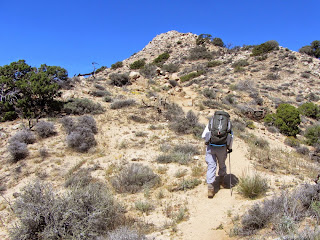
11:08 - Warren View Junction. We take a sharp left (northwest) and head to the peak which stands tall in front of us. I continue to snap pictures of flowers and rocks and lizards
11:32 - Warren Point (5103’) (J). Alright, check this puppy off of my HPS list! Wow, what a splendid summit! Its pointed, rocky top gives it a real peak feel. The 360-degree panorama is breathtaking. It’s windy up here and I’m regretting that I haven’t fixed my hat strap, which came off in the washing machine. We have line-of-sight toward most of Yucca Valley and Twentynine Palms Highway (Hwy 62) running through Yucca, so that means that one could see this peak from there. I’m scoping out some landmarks down there so I can locate this peak the next time I’m there.

Panorama north from Warren Point
There is a peak register in a container (after I finished the hike I realized that I neglected to even look at it! Bummer!). A clear path heads north along the ridgeline, which I had considered as an option in getting here while hitting summits 4789 and 4842 en route via High View Nature Trail. Maybe another time. This peak is certainly worth a return visit. Alan activates his SPOT Messenger to send an OK message to the responsible persons back home that indicates a goal of this hike has been attained and that we do not require assistance.
11:54 - Leave summit and retrace our steps down. Alan’s trekking poles give him an advantage in negotiating the steep slippery trail. Across the canyon, the Panorama Loop ridgeline defines the horizon. We can see our loop trail ascending the wash to meet the ridgeling.
It feels hot but Alan checks his instrument and finds it to be only 75.7 degrees. Alan has a Ph.D. from CalTech in mechanical engineering and has spent his entire career on the leading edge of advanced technology. So it’s no wonder that he is geared with lots of cool gadgets while hiking. He’s the ultimate modern hiker. Yet, he shies away from most new-fangled blogs with their bells and whistles; he still prefers old school trail guides that are well written, reliable, and formatted for the trail.
We continue up the canyon with its gentle slopes and gangly Joshua trees. The route bends east following the drainage. Behind us, Warren Point punctuates the horizon.
12:55 - Panorama Loop ridgeline. Oh, yes, this is nice. Sprawling desert spreads before us to the south. This is the place that Alan calls the Ed Rosenthal memorial junction. In October 2010, while hiking the Panorama Loop, 64-year-old Rosenthal missed the left turn here and got lost.
We veer left (east) and follow the trail up the broad ridge with varied views. A man and women pass us on their way down. We remark about the scarcity of hikers on the trail. He reckons that the crowds are swarming the popular tourist attractions in the central park. Yeah, probably a boatload at Ryan Mountain. Alan notes that this is prime rock climbing season in Joshua Tree and there are no decent rock climbing routes here. I’m really enjoying this trail now. We pass to the south of highpoint 5195’ and descend slightly to a saddle with a superb view north into broad canyon. We continue up the ridge for the final pitch to our furthest-most destination.
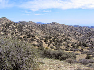
1:33 - Highpoint 5160’+ (K). What a great 360-degree panorama! Wispy high-level clouds add interest to the scene. We are surrounded by rugged desert. Ragged peaks accentuate the skyline.

Panorama southwest. Highpoint 5191’ is on right.

Panorama north from west (left) to east. Highpoint 5191’ is on the far left.
Many of the peaks are unnamed. (I hadn’t been paying close attention to the elevations, but after I got home and studied the topo more, I realized that highpoint 5191’ is the highest point on the rim of the Black Rock upper-western watershed, including being higher than Warren Point (5103’). It seems to me that 5191’, the pyramid-shaped pinnacle, needs a name. And it has a clear path climbing its eastern flank. I shall indeed aim to climb it on my next trip here.)
We leave the summit at 2:07. The route immediately begins to curve north and follows the descending ridgeline. There are a series of freshly built switchbacks which were not here when Alan hiked it last. As a Trailbuilder, I really appreciate the workmanship that went into building the rock retaining walls. Soon views open up northwest toward Warren Point.
2:53 - Junction with Black Rock Canyon Trial (F).
3:22 - Four-point junction for Upper West Side Loop and Burnt Hill Trail (D). We turn left and stroll the narrow path. There is such serenity to the expansive desert landscape.
We encounter a small group with a dog and I ask if they are aware that dogs are not permitted on the trails. They say they didn’t see any signs and continue up the trail with seemingly no regard for the prohibition. Such ignorance and defiance boggles my mind. There are very clear and important reasons for keeping pets out of this protected habitat. For example, as explained on the JTNP website, the very presence of pets in the park alters the natural behavior of native wildlife. Pet dogs are descended from wolves and still show predatory behaviors. Even the scents left behind by dogs may turn wildlife away from important habitats such as fan palm oases.
At 3:36 we reach the junction at the water tank (B). We turn left then curve right continuing north. I’m tired and ready to be done, yet I’m reluctant to end the rich experience of this superb hike in amazing landscape. At 3:42 we hit campsite #30 (A) and take a short pit stop at the restrooms which have flush toilets and running water, a rarity in JTNP.
3:50 PM - End hike. We go into the visitor center and thank the rangers for the excellent new switchbacks on the Panorama Loop. We also point out the mileage error on the loop sign. When we report the dog on the trail, the rangers are noticeably disconcerted and press us for details. It is obvious that these rangers passionately care about protecting this wonderful wilderness.
Epilog - What a thoroughly splendid outing! A total round trip of 8.15 miles with 1,820 in elevation gain/loss provided a rewarding workout. I really enjoyed Alan’s company. The weather was perfect. What wonderful wildflowers and scenery! I’m amazed at the amount of solitude we had on a beautiful spring Saturday on a well-publicized trail. The Park Service has done a great job with new trail signs (aside from the one mileage typo). I get to cross off another HPS peak. And with its network of assorted trails and peaks, Black Rock strongly calls me for return visits.
|
Waypoints (from Alan’s GPS)
(using WGS84 datum, at an elevation of 4,071 ft) B - N 34° 4.152’, W 116° 23.498’, 4,139 ft / Water tank junction C - N 34° 4.072’, W 116° 23.472’, 4,158 ft / West Side Loop Jct D - N 34° 3.883’, W 116° 23.310’, 4,126 ft / Four-point Jct, Burnt Hill E - N 34° 3.376’, W 116° 23.774’, 4,368 ft / Black Rock Spring F - N 34° 3.225’, W 116° 23.792’, 4,450 ft / Panorama Loop Jct, lower G - N 34° 3.046’, W 116° 23.969’, 4,577 ft / Panorama Loop Jct, upper H - N 34° 3.079’, W 116° 24.288’, 4,743 ft / Warren View Jct I - N 34° 3.126’, W 116° 24.494’, 4,880+ ft / Warren View J - N 34° 3.305’, W 116° 24.432’, 5,103 ft / Warren Point K - N 34° 2.700’, W 116° 23.132’, 1,560+ ft / Highpoint 5160’ |
See Warren Point on Peakbagger.com (includes GPS tracks on topo map for various routes)
NEXT > Joshua Tree - Crown Prince Lookout - December 20, 2015
PREVIOUS > Joshua Tree: Indian Cove and Mount Mel - Jan. 4, 2015


Awesome pictures, Dan! Thank you for sharing. :)
ReplyDelete