What a superb experience spending the night on the 8693-foot summit of Ontario Peak, enjoying a beautiful sunset and sunrise, an amazing panorama of human sprawl and spectacular high country, great weather, solitude, and good company.
Ontario Peak had been on my hit list for a number of years and so finally it was time to climb it. At 12.2 miles round trip with 3,800 feet in elevation gain, I knew I wanted to hike it as an overnighter so that I can take my time and enjoy this wonderful high country.
Early Saturday morning, my friend, Mark, and I head east on the 210 freeway then north up Mt. Baldy Road to the Visitor Center to pick up our wilderness pass that is pinned to the board. Then on up to the Icehouse Canyon parking lot and are happy that there are still parking places available at this immensely popular trial.
 7:10 AM - Begin our trek up Icehouse Canyon Trail. The weather is pleasantly cool. Our pace is casual as we enjoy the beauty of the tree-covered, flowing stream. Lot of other hikers on the trail. Enjoy taking pictures of some of the rustic cabins en route. At one mile we pass the junction to Chapman Trail, where I hiked a month ago.
8:25 - Cucamonga Wilderness boundary, at 1.8 miles. Now on the south side of the creek. The landscape is breathtaking! At Telegraph Wash we cross back over to the north bank and begin the steep ascent along the slope taking us high above the canyon bottom.
 9:11 - Columbine Spring. Love the refreshing water! I fill up a one-liter bottle. We meet up with Don and Kathy, friends of Mark who he arranged to meet us. Continue up the steep trail with an eye to the massive slopes south across the canyon with the anticipation we will be up there in a while. Our pace is relaxed.
10:03 - Chapman Trail junction. Only 0.6 mile more to the saddle. Superb scenery. Don shares his story of being rescued by helicopters out of Laurel Gulch. The terrain is less steep now with blankets of thick manzanita.
 10:33 - Icehouse Saddle. Lots of people. We sit on the large log and chat and enjoy the cool breeze. People coming and going. Don and Kathy say goodbye and head down the trail. Mark and I leave the saddle at 12:03 and head southwest on Ontario Peak Trail. The sign indicates 1 mile to Kelly’s camp and 2.8 miles to Ontario Peak. I’m excited because after the first quarter mile, I’ll be on a trail I’ve not yet hiked. The scenery continues to be breathtaking as we traverse the north slope of Bighorn Peak. The temperature is still nice and rate of climb is very gentle. Great views across to Timber Mountain, Telegraph Peak, and good ol’ Mt. Baldy in all its glory.
1:10 - Kelly’s Camp. Finally get to experience the place I’ve read about. I pull out some old photos of Kelly’s Kamp (as it reads on the un-dated post card) and attempt to match the location of the foundations to the cabins pictured. We eat lunch and talk with others arriving at the site.
 2:00 - Leave Kelly’s Camp. The trail conveniently goes up the steps of a cabin foundation and climbs south zigzagging through the trees. In a few minutes we transition from a shady forest to an open bowl which had been incinerated by fire years ago leaving a toothpick forest. The ridge is in sight. The trail is a little brushy here.
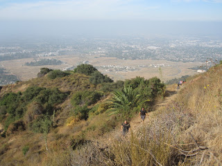
2:29 - Ontario Ridge. Wow! Great view south to the suburban sprawl! The trail on the left heads east to Bighorn Peak, 0.7 mile away. We linger here for about ten minutes then proceed west. The trails contours around the north flank of a large bulge on the ridge. As we round the hip, more of the ridge comes into view with a prominent outcropping just up ahead.
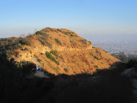
 3:28 - The trail arrives at the ridge again with more views south. The route continues below the ridge on the north. As we round another hip, Ontario Peak comes strikingly into view, although we are not certain it is indeed the peak since there are several “false” summits en route. The “toothpick” forest is a stark reminder of the destructive fire. In a few more minutes we intersect the ridge again with more great views south. The fractured, rugged terrain of the steep southern walls is amazing. The trail continues west, now more closely following the ridge. We reach foot of the final pitch to Ontario Peak. The trail climbs steeply a zigzagging route and in a few minutes begins to level out as the rocky outcropping of the peak looms 150 yards ahead. We note a large flat area here that would be suitable for camping.
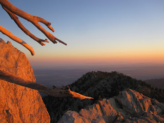
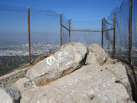
 4:35 - Ontario Peak (8693’). Wow, what a great summit! I climb around the rocks to experience the views from all directions. Mark has cell reception and calls home. The late afternoon haze and low sun gives the layered, silhouetted ridges to the west a blue tint. This peak has to rival any peak in the San Gabriels for numbers of peaks in view; I identify 35.
 Mark and I sit on the summit for a long time and just talk while soaking in the views. We set up camp in the flat area about a 125 yards east of the summit—ideal location. Eat dinner (all cold—no stoves on this trip). Walk back over to the summit outcropping to watch a beautiful sunset and the twinkling lights of sprawling humanity. We both agree that the overwhelming majority of those who summit Ontario Peak don’t experience this twilight picture or the dawn picture that we will enjoy after a night’s sleep.
 We retire around 9:00. I love sleeping under the stars (and satellites). At about 1:30 a.m. I get up and walked around. There is an amazing beauty of nighttime on a high mountain peak. The temps are cool but not bad. Breezy all night. A nearly full moon provides lots of light.
5:45 AM Sunday - Snap a picture of a superb dawn then snooze until I snap a pic of sunrise at 6:22. Get up, eat, and pack up. Mark and I have “church” on the summit rocks in one of the most beautiful sanctuaries in which I have ever worshipped. Enjoyed the panoramas in a different light.
 8:30 - Left Ontario Peak. Enjoying the coolness of morning and beautiful views. In about half hour I stop to look at a snake track crossing the trail. When Mark stops to look at it with me we are startled by the sound of a rattle! There off the trail about eight feet away a large rattlesnake coiled himself and rattled his tail vigorously. It was quite a treat for us!
9:00 - Reach a shallow saddle and notice signs of bighorn sheep—lots of tracks, scat, and bedding recesses. We decide to go off trial and follow the ridge. Lots more signs of the bighorns. I’m really hoping to see one of these amazing animals. Enjoy exploring. Finally get to a section where a large outcropping prevents us from safely proceeding. A lone hiker with his metal poles clanking passes below us on the trail. We drop down to the trail and soon round the hip and zigzag down a series of switchbacks. Three men are climbing up.
 10:06 - Saddle junction to Bighorn Peak. Meet a group of seven hikers coming up. Their group is called SOA. Enjoy chatting. They proceed west to the peak; we head down at 10:32.
10:46 - Kelly’s Camp. Look for the spring and find it about 150 yards west. There is only an occasional drip coming from the pipe but there is water in the little basin, which could be filtered if one needs to refill. More hikers on their way to Ontario Peak. Leave at 11:06. I love the scenery of this high country.
 11:37 - Icehouse Saddle. I count 16 people here. Hikers coming and going. Strong breeze. See several deer including two or three fawn. A man shows us a pic of a bighorn sheep he saw this morning en route to Cucamonga Peak. Leave saddle at 11:53 for our final 3.6 miles. Two females come up the trail with their black Labradors not on leashes. I remind them of the regulation. Trail gets steeper. My pace is slower than Mark’s, trying to take it easy on my feet and knees, and to enjoy the scenery. Lots of people on the trail.
12:12 - Chapman Trail junction. Getting warmer. Those coming up the trail are really sweating. Sunshine good for picture taking.
 12:36 - Columbine Spring. Fill up my one-liter bottle. The water is so cool and refreshing. There are always people here every time I’ve been here. Linger for awhile. Trail gets rougher as it crosses the canyon bottom at Telegraph Wash and heads down the south bank. The rocky trail surface make descending tedious.
1:16 - Wilderness boundary. Seems there is always people here too. Yup the sign is still there: “PLEASE KEEP PETS ON LEASH.” Soon we cross the creek to the north side. Some shade feels good. Getting hot now. Big crowd of people at one of the shady pools. Stop when a couple points out a rattlesnake in the brush. Our second rattler of the day—cool!
 1:40 - Chapman Trail junction. Only one more mile. I’m ready to be done. More shade in this section now. My camera’s 4G disk reaches its max. I delete a few low-priority photos to free up some space for the end of the hike. Encounter the women with their dogs again, still off leashes. I address them but they remain defiant. The “conversation” invigorates me and my pace picks up.
2:24 - End of hike. What a splendid outing!! I report the dog ladies to the volunteer Forest Service worker. The women emerge with their dogs on leashes—imagine that! The forest worker speaks with them but they merely dodge any responsibility for their actions and remain defiant.
Epilog - Well, I didn’t see any bighorn sheep, but some deer and two rattlesnakes were a treat. This hike ranks among the finest ones I’ve done in the San Gabriels. It certainly is comparable to other grand summits such as Baldy, Baden-Powell, Telegraph, and Cucamonga. But spending the night on the summit of Ontario Peak pushes it over the top as a truly special experience.


