Showing posts with label Lower Monroe Road. Show all posts

Thursday, November 26, 2015

Mystic Canyon and Lower Monroe Hike - November 26, 2015

View southwest from the junction of Mystic Canyon Trail and Lower Monroe Road, Glendora
Thanksgiving

Thanksgiving is a good time to hit the trail and be thankful for creation and the beauty of nature. I’ve done a few Thanksgiving hikes over the years as holiday plans permitted. Since I have the morning free today before leaving to celebrate Thanksgiving with family, I have the opportunity to hike, as do a couple friends.

I drive to Glendora and meet John and Rick at Rick’s house. We pile into the car and take the five-minute drive to the Mystic Canyon trailhead in Big Dalton Canyon. There are lots of cars parked at the intersection of Glendora Mountain Road (GMR) and Big Dalton Canyon Road and at the trailhead. It’s a brisk 52 degrees.

Mystic Canyon trailhead, Big Dalton Canyon Road, Glendora Mystic Canyon Trail, Big Dalton Canyon, Glendora
View southwest toward Glendora from Mystic Canyon Trail Heading north on Mystic Canyon Trail, Glendora
8:10 Begin hike. I forgot how crazy steep the first section of the trail is. I assure my buddies that shortly it mellows out and the rest of the hike is quite gentle. It’s cloudy and brisk and we welcome the generated heat from the steep climb. We enjoy the expanding views of Glendora and think about Thanksgiving preparation happening in many of those homes. We exchange Thanksgiving greetings with others on the trail. Rick and John are engaged in considerable conversation but I hang back a little and just soak in the beauty of my surrounds. There is virtually nothing in bloom and deciduous plants like poison oak are hunkering down for the winter with their leafless stems. Some recent rain has invigorated plants from the arid months while weedy grasses are brown and dead. The chaparral has wonderful fragrance. A sunflower cheerfully greets us. Common sunflower (Helianthus annuus) along on Mystic Canyon Trail, Glendora I am so thankful for the splendor of nature!

Our route climbs north along the western side of Mystic Canyon, a tributary to Big Dalton Canyon. We choose to take the two long switchbacks for the final pitch rather than steep use path from Poop-Out Trail.

View northeast toward Summit 2760 from the junction of Mystic Canyon Trail and Lower Monroe Road
8:49 - Junction with Lower Monroe Road (aka Truck Trail). Wonderful vistas! Three gals have Rick take their picture. A small America flag attached to the sign post flutters in the wind. Patchy sun peaks through the clouds. Across Little Dalton Canyon to our west, vehicle noise on GMR detracts from the serenity. To our northeast, Summit 2760 stands pointed against the sky, but we won’t bag it today. Our plan is a two-hour hike, so when we get to the 60-minute point, we’ll turn around and head back.

View southwest toward Little Dalton Canyon and Glendora Mountain Road from Lower Monroe Road
After a few minutes at the junction, we head northeast on Lower Monroe Road and enjoy the expansive view north. Occasionally mountain bikers swoosh by us. I suspect that most are doing the one-way downhill from GMR, about a nine mile ride. A mother and her young daughter (maybe 10 years old), both clad in colorful riding gear, come racing down the trail. The young lady enthusiastically greets us, “Happy thanksgiveeeeeeeing!” as she wizzes by. We reach the sign post for Punk Out Trial and stop for a selfie (does not turn out well so we retry on our return).

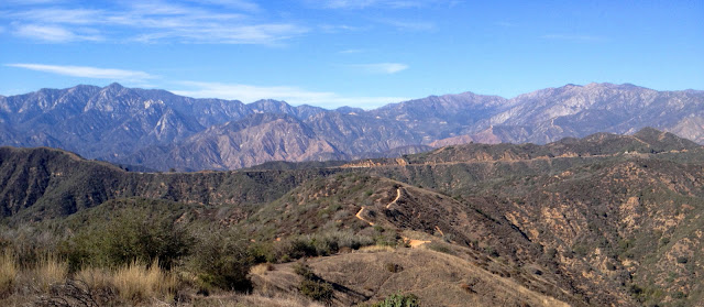
9:11 - Reach our one-hour mark and take a brief stop. The view north begs for a panorama shot.

Panorama north from Lower Monroe Road with Summit 2760 on right

We turn around and head back, now engaged in a lively conversation about creationism. I’m not an expert but I’m thankful for a personal relationship with the Creator! When we reach the Punk Out post, a pair of cyclists offers to take our picture. Our descent is pleasant. Heading southwest on Lower Monroe Road Such a beautiful autumn day!

9:35 - Mystic Canyon junction. We linger for a few minutes, chat with a family of cyclists, and enjoy the views. View west toward Little Dalton Canyon and Glendora Mountain Road from the junction of Mystic Canyon Trail and Lower Monroe Road The trails are getting lots of use today. We retrace our steps down Mystic Canyon Trial and continue to appreciate the gifts of rugged scenery and good friends.

Dan Simpson, Rick, and John on Lower Monroe Road at Punk Out junction, Angeles National Forest
10:10 - End hike.

Epilog – What a pleasant outing! Splendid trail, fresh air, brisk temperatures, picturesque clouds, superb vistas, aromatic chaparral, and a sense of holiday set aside for being grateful. We have so much to be thankful for! icon
Psalm 100 (Holy Bible, English Standard Version)
Make a joyful noise to the Lord, all the earth!
     Serve the Lord with gladness!
     Come into his presence with singing!
Know that the Lord, he is God!
     It is he who made us, and we are his;
     we are his people, and the sheep of his pasture.
Enter his gates with thanksgiving,
     and his courts with praise!
     Give thanks to him; bless his name!
For the Lord is good;
     his steadfast love endures forever,
     and his faithfulness to all generations.

  Experience the Creator

See Mystic Canyon Trail & Lower Monroe Road to Summit 2760 and Summit 3397 Hike Description on Dan’s Hiking Pages

PREVIOUS > Mystic Canyon and Lower Monroe Hike - January 25, 2014

Sunday, November 8, 2015

Glendora Mountain and Summit 3397 - November 8, 2015

View north from the north ridge of Summit 3397, Angeles National Forest Although oft overlooked and somewhat lackluster, these two peaks offer amazing panoramas over the heart of the San Gabriels. Gorgeous weather and some lean hiking months drew me to the mountains. I’ve visited both peaks multiple times, but it’s time to return. During the Colby Fire of January 2014, the Forest Service cut dozer lines on the ridges of Glendora Mountain, so I’ve wanted to see how it impacts the hike to the peak. And I’ve not hiked to Summit 3397 from the north, so this would be a good chance.

Trailhead on Glendora Mountain Road for Glendora Mountain, Angeles National Forest
The drive up Glendora Mountain Road (GMR) is somewhat dicey with all the bicyclists coming and going. They really put themselves in danger sharing the narrow, windy road with motor vehicles. Around every bend I face the possibility of cyclists in the middle of the lane. I finally reach the trailhead at mile marker 6.50. I don’t need an Adventure Pass since the rules have changed and passes are required only in locations with guest amenities.

Glendora Mountain Hike

View south toward Glendora Mountain, Angeles National Forest
10:00 AM - Begin hike (3120’). The temperature is pleasant in the upper 60s with warm sun and gentle breezes. The route heads west up the firebreak following a narrow path along the right edge. Cut brush covers the break (probably to limit erosion). Seven minutes delivers me to the first high point (3311’) along the undulating ridgeline, now bending south. It’s quite peaceful here aside from the occasional roar of motorcycles along GMR…the epitome of noise pollution. The ridgeline offers a spectacular 360-degree panorama of the surrounding San Gabriels and numerous peaks which have become familiar friends.

View south along Glendora Mountain ridge, Angeles National Forest
There is virtually nothing in bloom aside from some lingering California buckwheat and a few asters and sunflowers. Wildflowers on Glendora Mountain ridge, Angeles National Forest I can hear occasional gun shots from the Burro Canyon Shooting Park about four miles north as the crow flies. The sky is blue and cloudless. Up and down I go along the rollercoaster ridge. For the most part it’s easy going. The firebreak has softened with nearly two years of vegetation growth. I see virtually no trace from the 2002 Williams Fire and the 2009 Morris Fire, which incinerated most of this mountain; chaparral rebounds well. The last time I was here (February 2011), the temps were in the 40s and I was leaving boot tracks in an inch of snow. Today is quite different.

View northwest toward the Cabin Fire burn area in North Fork San Gabriel Canyon from Glendora Mountain ridge, Angeles National Forest
I’m enjoying the grand scale of the scenery. To the north about 4.5 miles in the San Gabriel Canyon, the footprint of the August 2015 Cabin Fire, which consumed more than 1,700 acres, stands out a tan scar on the southeast slopes of Smith Mountain and vicinity. To my left (east) I peer down into the upper reaches of Little Dalton Canyon blanketed with rich green vegetation. Looking down into San Gabriel Canyon on my right (west), I see cars snaking up Hwy 39. San Gabriel Reservoir comes into view to the northwest. The water level is still low but a predicted El NiƱo for this winter could fill it up to overflowing. Noisy vehicles on GMR remind me I’m not really in a wilderness. Over each bump on the ridge I get closer to my destination.

View southwest toward Morris Reservoir from Glendora Mountain, Angeles National Forest
10:35 - Glendora Mountain (3322’). Achieving the summit is not that climatic since there were sweeping views all along the ridge route. I am, however, now rewarded with a grand view south. Haze somewhat mutes the human sprawl in the valleys below. The Downtown L.A. and Century City skylines are but faint silhouettes in the distant southwest. Catalina Island forms a faint line on the horizon. Across the canyon to the east stands Summit 3397 inviting me to climb it next. View east toward Summit 3397 from Glendora Mountain, Angeles National Forest

View northwest toward San Gabriel Reservoir from Glendora Mountain, Angeles National Forest
I sign the peak register, contained in a white PVC tube lodged in a small pile of rocks. Peak register on Glendora Mountain, Angeles National Forest The summit doesn’t get a lot of traffic. The last visitors were a group of seven on October 24—two weeks ago. The logbook was started on May 17 with a group of 13; I recognize some of the names as Sierra Clubers. Glendora Mountain is on the Sierra Club Angeles Chapter Lower Peaks Committee List. I linger for a long time just enjoying the expansive scenery and solitude.

View northeast toward Little Dalton Canyon, Glendora Mountain Road, and the Baldy high country from Glendora Mountain, Angeles National Forest
11:35 - Leave summit and retrace my steps along the rollercoaster ridge. My car is a speck on the distant road. A sweeping northern panorama of the central San Gabriels spreads out before me. I survey ridges and peaks and ponder hikes I’ve done and potential new adventures. GMR is pretty close below via several ravines along the west-facing slopes; I’ve considered if any of these would provide a viable shortcut from the road to the ridge, but the brush is so thick that only an animal would attempt such a passage. View northwest toward Glendora Mountain Road from Glendora Mountain ridge, Angeles National Forest And a shortcut…really? The whole hike is only 2.0 miles round trip! I curve around to the east and begin descending my last 191 vertical feet to the end. View east toward Glendora Mountain Road returning from Glendora Mountain, Angeles National Forest
12:08 - End hike. So 35 minutes up and 33 minutes down, and an hour on top.

Tom Harrison Map Angeles High Country
I continue my drive east on GMR 1.2 miles to the large turnout for Forest Service road 2N16 (Lower Monroe Road) on the right (there is no mile marker here but 5.08 is 300 yards further east). A couple vehicles are unloading mountain bikers for a one-way a ride down 2N16. I’m wonder if the one young lady driving away is the girlfriend of the rider she dropped off. That’s one way to a guy’s heart. I linger in the car, have a bite to eat, and study the map.

Summit 3397 Hike

View east toward Glendora Mountain Road and Mount Baldy from Lower Monroe Road (2N16), Angeles National Forest
12:40 - Begin hike (3420’). Walk past the locked vehicle gate and head south on 2N16, Lower Monroe Road (aka Lower Monroe Truck Trail). In few minutes I round the bend and see my summit in the distance. It seems like a long way away. Soon I am rewarded with great views east and west as the road follows the rollercoaster divide between Little Dalton Canyon on the right (west) and Monroe Canyon and the Big Dalton Canyon watershed on the left (east). The sun is warm and a few wispy clouds now add interest to the blue sky. The dirt road shows the heavy traffic of bicycles. I’m surrounded by thick chaparral. Shy of 15 minutes (0.6 mi.) I reach a fork. The left heads up past an apiary clearing (for bee hives) to high point 3386. I may hit it on my way back. The road bends right to bypass the highpoint. It’s just a beautiful day for sauntering through the rugged scenery. View south toward the north ridge of Summit 3397 from Lower Monroe Road (2N16), Angeles National Forest I’m really enjoying solitude.

1:13 - Junction to the summit. The road continues to the right but I veer left past the apiary clearing and climb the old firebreak. View south toward the north ridge of Summit 3397 from Lower Monroe Road (2N16), Angeles National Forest Views east become outstanding, but they are even better when snow blankets the high country.

1:26 - Summit 3397. The broad top is mostly rimmed with high vegetation obscuring views except for east. I photograph the eastern panorama before wandering around the summit.

View northeast from the north ridge of Summit 3397, Angeles National Forest


I’ve been here three times before, but those were from the south (twice from Mystic Canyon Trailhead in Big Dalton Canyon, 2,217 vertical feet below, and once from little Dalton Canon). I wander over to the clearing with great views south. Before me lies the San Dimas Experimental Forest. View southeast toward San Dimas Experimental Forest from Summit 3397, Angeles National Forest Beyond is the vast human sprawl. The sun gleams on the distant ocean. View southwest from Summit 3397, Angeles National Forest I attempt to find a spot to take a pic west toward my earlier peak, but there’s too much brush.

View west toward Glendora Mountain (3322’) from the north ridge of Summit 3397, Angeles National Forest
1:50 - Leave summit and retrace my steps down. A spot on the ridge gives me a shot west to Glendora Mountain. Seven minutes delivers me to the road. I enjoy the scenery as I amble along. Heading north on Lower Monroe Road (2N16) with high point 3368 on the right, Angeles National Forest A small snake about 12 inch long slithers across the trail and disappears into the brush before I can snap a picture of him. His coloring suggests a gofer snake. At the junction past high point 3386, I double back, walk past the apiary clearing, and walk the 200 yards to the summit. It’s brushy and nothing to write home about, but it does provide a nice view south toward summit 3397. Back on the road I continue north. Green toyon berries promise to add a splash of red to the coming winter chaparral. Firebreaks on slopes north of GMR beg to be explored. View north toward Glendora Mountain Road from Lower Monroe Road (2N16), Angeles National Forest

2:49 - End hike. Trailhead for Lower Monroe Road (2N16) at Glendora Mountain Road returning from Summit 3397, Angeles National Forest I’m done. I drive east another 0.3 mile to the junction of GMR and Glendora Ridge Road. I get a nice shot back toward Summit 3397.

Dan’s boot print on Lower Monroe Road returning from Summit 3397, Angeles National Forest
Epilog - A very pleasant outing! The weather was simply gorgeous. The distance was not great (2.0 mi. r.t. for Glendora Mt. and 3.0 mi. r.t. for Summit 3397), but the satisfaction level was high. It’s amazing to me that I can be on such fine trails within 20 minutes of massive human sprawl on a beautiful weekend, and encounter no one. In fact, on Glendora Mountain, I had quite a prayer meeting feeling the seclusion of the summit sanctuary. Being in nature always inspires me toward communing with the Creator. icon

See Hike Descriptions at Dan’s Hiking Pages
(Detailed trail guides include driving directions, recommended season, map, notes, links, and photos)
blogspot Related links on Dan's Hiking Blog:

Saturday, January 25, 2014

Mystic Canyon and Lower Monroe Hike - January 25, 2014

View north from Lower Monroe toward Summit 3397
See Mystic Canyon Trail & Lower Monroe Road to Summit 2760 and Summit 3397 Hike Description on Dan’s Hiking Pages

The devastating Colby Fire that consumed nearly 2,000 acres of our beautiful mountainside above Glendora and Azusa last week has been occupying my mind. I felt compelled to hit the trail today to achieve a vantage point to survey the east end of the burn zone where it started. Mystic Canyon Trail and beyond is ideal for such a hike.

Upper Mystic Canyon Trail trailhead in Big Dalton Canyon
My wife drives me to the trailhead since it is close to home and she needs the car today. We turn onto Glendora Mountain Road and a lighted sign reads, “Hiking Trails Closed.” I don’t suspect that that applies to where I’m heading, and it didn’t. We turn right onto Big Dalton Canyon Road and drive the half mile to the trailhead. There are ten vehicles parked here. It’s brisk.

View southwest from Upper Mystic Canyon Trail toward the mouth of Big Dalton Canyon
9:00 AM – Begin hike on Upper Mystical Canyon Trail. Within a couple minutes the trail gets crazy steep. I had forgotten how steep it is. But the steepness doesn’t last long and soon I’m out of the shade and views open up to the southwest beyond. A group of about 12 young folks and several adults pass by heading down. I’m enjoying the rich chaparral…such a contrast to my burned mountain in Azusa. It almost feels like summer with so many of the plants being parched from our drought conditions.

View west from Poop-Out Trail across Little Dalton Canyon toward GMR and Upper Colby Trail
I slip and fall and get a nasty scrape on my wrist. Thankful for coagulation. Summit 2760 comes into view at the head of canyon. I snap pics of wild cucumber and purple nightshade flowers, the only thing I’ve seen in bloom so far. Tiny leaves of poison oak emerge from dormant sticks. At the saddle, I turn left (west) take the short spur trail to Poop-Out Trail that runs along the ridge. I get my first good views west across Little Dalton Canyon toward the burn area. What’s encouraging is mountainsides covered with mature chaparral untouched by the fire. I turn north for the steep climb.

View northeast from Lower Monroe Road toward Summit 2760
9:43 – Lower Monroe Road. Looking north toward Glendora Mountain, I get a good view of the freshly cut dozer lines. I chat with a mountain biker. There are other trail users but it doesn’t feel crowed. The warm sun feels good. I head northeast on the old truck trail, which points directly to Summit 2760. Within a minute I veer right and transition to the ridgeline which parallels the old road, just to follow a narrow path. Views are expansive over the rugged chaparral-covered mountains. Two lone blossoms of California buckwheat bask in the sun. What’s absent is the green grass that would normally present this time of year.

Junction of Lower Monroe Road and Punk Out Trail heading to Summit 2760
Soon the route rejoins the main trail and I come to a post marked “Punk Out.” The post also says Dalton IHC. I have no idea what that means but later a Google search reveals that it probably refers Dalton Integrated Hotshot Crew. I veer right unto Punk Out Trail to continue my saunter long the undulating ridge. It’s steep in spots, providing an opportunity to catch my breath while enjoying the sweeping panorama.

Climbing Punk Out Trail up the steep south ridge of Summit 2760
When I arrive at the base of the steep section going straight up the south ridge of Summit 2760, I sit for a break and treat my abrasion. At 10:40 I begin my climb. I’ve come down this route before but I think this is my first time to climb it. It’s crazy steep and certainly not for the faint-of-heart. Soon I see a young man coming up the trail behind me. His pace is faster and he passes me. I continue up, carefully choosing the spot for each step and stopping occasionally to catch my breath. I’m encouraged when I see bicyclists cross on the trail not far above.

11:02 - Reach Lower Monroe Road again near Summit 2760. What a climb! I chat with the young man, whose name is Clayton. He is student at the Rio Hondo College studying to be a wildland firefighter. We say goodbye and I continue north up the road at 11:27. In a couple minutes I reach the saddle then double back for the finial climb.

View west from Summit 2760
11:33 - Summit 2760. This is really a splendid peak. It should have name. I post a pic to FB. Due west across Little Dalton Canyon is Summit 2583, where I was on December 31 before descending Upper Colby Trail. A newly cut dozer line replaced the path I walked up to the summit from Glendora Ridge Road. A helicopter lands on the summit. I suspect it has some function related to the fire.

View southwest from Summit 2760
From this perspective I see only a small portion of the burn area. In contrast, I am surrounded by many thousands of areas of mature chaparral. I’m encouraged because I know that most of this area was incinerated by the 2002 Williams Fire, which burned 37,240 acres. Now it’s thriving nicely. A prime motive for today’s hike was to view Colby Fire damage. What I did not anticipate was the therapeutic value of being surrounded by miles of rich, mature wildlands. It is so peaceful and rejuvenating here.

Lower Monroe Trail rutted from bicycle traffic
When I started today, I did not know how far I’d hike, thinking maybe I’d turn around at this point. But now that I’m here, I think I’ll continue on to Summit 3397, which stands north north east and calls me higher.

I leave the summit at 11:55 and in three minutes I’m back on the road. I’m enjoying the scenery and solitude. Three mountain bikers swoosh by. One of the downsides of this trail is that are many segments where the trail tread has been worn into a rounded trench by the bike traffic. It makes it uncomfortable to walk.

View east from Lower Monroe Road Iron Mt., Pine Mt., Dawson Peak, and Mt. Baldy
Although there is virtually nothing in bloom, some occurrences of ceanothus, purple nightshade, Spanish broom, and current add a few tiny dots of color amidst a vast sea of gray and varied muted greens. Some views open up east toward Mt. Baldy and Ontario Ridge. It’s odd to see them without snow in January. I think about some friends who are hiking there today. As I get closer to the broad ridge dropping south from Summit 3397, I think about my adventure bushwhacking down that route a few years back. Today I don’t see any sign of a clear route. I stay on the trail. As the route bends around the west hip, views toward the north open up. Traffic on GMR puzzles me because it’s supposed to be closed today. Scattered high clouds add interest to blue sky. I arrive at the junction north of the summit at 12:49 and am treated to a striking panorama of the eastern high country. I turn right (south), pass straight through the old beehive area, and begin the gentle climb up the old firebreak. A lupine stands tall with it first purple bloom of the season.

View east from Summit 3977
12:59 - Summit 3397. The large, flat summit is the highest point in this section of the range. I’m surprised that it’s not named. It offers commanding views except toward the northwest, which is obscured by vegetation. I sit in a clear spot on the southwest edge, post a pic to FB, and soak in the beauty. Far below me I see my trail. Summit 2960 looks tiny from here. Beyond the mountains to the south, the vast human sprawl disappears into haze. I look over the expansive San Dimas Experimental Forest which covers 32-square miles to the south and east of where I sit. I ponder its peaks, ridges, canyons, and waterfalls…most never or rarely visited by humans and off limits to the public. Which begs the question, how would I know that I can’t just leave this summit and descend into the forbidden furrows below? There are no signs anywhere en route. Of course if I was arrested for trespassing and pleaded ignorance, they would take one look at my website and quickly realize that I’m far for ignorant. So I guess I’ll be a good boy and stay out, at least today.

I leave the summit at 1:30 and begin to retrace my steps. When I arrive at the road, I wander north for a few minutes to get some different views. Back at the junction I continue my homeward trek. I’m always amazed that I can hike in such a splendid local and have it virtually to myself. Where are all those hundreds of Garcia Trail hikers now that it’s closed?

I pass by the Punk Out junction near Summit 2760 at 2:25, choosing to walk back via Upper Monroe Road rather than down Punk Out…it’s just too steep for downhill, at least today. I enjoy the zig-route down the west-facing slope. A sticky monkey flower is in bloom. A couple mountain bikers pass. Stop and chat with three hikers; one is Tommy, who I met on Garcia Trail a couple years ago. I pass the spur trail that connects to the bottom end of the Punk Out steep section at 3:15. I pass the Punk Out post at 3:25. I’m aware that a good section of this return route is new track for me today since I walked along the ridgeline earlier.

View south toward Poop-Out Trail Glendora from the junction of Lower Monroe Road and Upper Mystic Canyon Trail
At 3:35 I reach the Upper Mystic Canyon Trail junction. I chat with a gal who just hiked up. I head down Mystic (new section for me today) then at the saddle I transition unto Poop-Out Trail for my descent, just to keep mixing things up. And I figure since I’m being picked up, I’d save the half-mile walk between trail heads.

The first part of Poop-Out is mild. Then there are a couple steeper sections which require some careful steps. Then I reach the nightmare. The route is absurdly steep with precarious footing. It’s just crazy! Note to self: Never descend this way again! I cautiously pick my down, sometimes with all fours and on my butt, and sometimes backwards. About halfway down I put on my leather gloves for protection. I’m not having fun. I reach the landing at the switchback and can see my wife parked below. The route gets sane. I make it safely to the bottom in one piece with no falls or injuries. Thankful!

4:35 - End hike.

Poop-Out Trail trailhead on Glendora Mountain Road and Big Dalton Canyon Road
Epilog - A most rewarding day! I covered about 8.5 miles with 2,300 feet in elevation gain. That’s a good workout. I loved the solitude and serenity yet enjoyed some interaction with others. The weather was amazing and the snowless backcountry in January was strange. I was able to view some of the Colby Fire areas but was rejuvenated being surrounded by miles of mature plant life. icon

See Mystic Canyon Trail & Lower Monroe Road to Summit 2760 and Summit 3397 Hike Description on Dan’s Hiking Pages

See Colby Fire - January 16, 2014 blog post