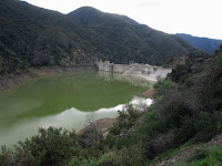
11:30 AM - Leave my house in Azusa and head north on Hwy 39 into San Gabriel Canyon. The beauty of the day and surrounding scenery captivates me. I open the sunroof to experience the brisk air. Lots of water in Morris Reservoir but not over the spillway. Across the canyon to the east I see snow on Glendora Mountain (3322’)
11:59 - Reach East Fork Road and turn right (east), crossing the bridge.
12:16 - Turn left on Shoemaker Canyon Road and drive the two miles to the trailhead. I love the aromas and beauty after a storm. It’s 48 degrees but feels colder. The Heaton Flat parking lot looks full in the canyon below. I drive back to East Fork Road and turn left (east) and head to the Heaton Flat parking lot. It is completely full and cars are parked down the road. Where are all these people hiking to? The Bridge to Nowhere? I sure wouldn’t do it in this weather. Maybe they are prospecting. Clouds are threatening. Continue on my way.
12:56 - Turn left on Glendora Mountain Road (GMR) and begin my ascent southwest into mountainsides dusted with snow. Wow, it’s beautiful here. Stop occasionally to take pictures. Make a snowball.
1:18 - Reach Glendora Ridge Road junction at the ridgeline and stop to enjoy the vistas with others. Back in the car, I head west on GMR.
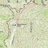
1:38 - Arrive at the trailhead for Glendora Mountain (road marker 6.50), on a narrow ridge dividing Little Dalton Canyon to the south and Persinger Canyon to the north (a tributary of San Gabriel Canyon). The car thermometer reads 43 degrees, but it feels warmer than when it read 48. I haven’t hiked to this summit since 2001 so am eager to revisit it.
Glendora Mountain Hike
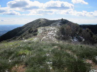
1:40 PM - Begin hike. The path starts on the south side of the road and heads west up a firebreak. It’s a bit steep but not bad. A Spanish broom hosts a few yellow blossoms. An inch of melting snow crunches beneath my boots. Fresh coyote tracks mark the route.
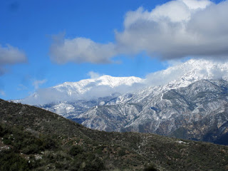
The ridge bends to the south and the summit is in view, less than a mile away. Clouds veil 10,000-foot Mt. Baldy to the east, which certainly is buried with snow. San Gabriel and Morris reservoirs soon come to view in the canyon below. I roller-coaster along the ridge now heading south, following the tracts of the coyote. Great views in all directions. The snow gives the scenery a very different feel.
2:23 - Glendora Mountain (3322’), about 1.0 mile and a total rollercoaster gain of about 378 feet from the start. I enjoy the unobstructed 360-degree panorama.
3:00 - Leave Summit. I follow my footprints in the snow and enjoy the snow-covered panorama to the north. My hands are cold but I don’t bother getting out my gloves. The evidence of fire abounds.
3:38 - Finish hike. The car thermometer reads 51 degrees. I drive down the meandering GMR toward Glendora, stopping several times to soak in the picturesque scenery.
Epilog - Another rewarding experience in the San Gabriels! For this outing, the car trip was as much a part of the experience as the hike. I love my mountains!
(Detailed trail guides include driving directions recommended season, map, notes, links, and photos)
- Glendora Mountain (via Glendora Mountain Road)
- Glendora Mountain and Summit 3397 - November 8, 2015


Greetings Dan!
ReplyDeleteYesterday my family and I did this wonderful hike! First, I wanted to inform you and all your readers that the FS recently grated this firebreak (I think about 2 months ago). There are some cut bushes on the first incline section of the trail but otherwise it's a nice, wide, and clear trail all the way to the peak! Unfortunately, the summit register is now missing (or at-least I couldn't find it... [but I did find a geocache :D ]).
Second, I just wanted to say thanks for the work you do to your site! If it wasn't for you, I would never have known about this hike. Infact, the only other hikers we bumped into on the trail was another family who used your site to find this hike also!
Thanks again, God Bless, and happy trails to you,
Joseph
Hi Joseph, thank you for the update and kind words. I’m always encouraged to know my efforts are helpful to others.
DeleteYes, the FS did re-doze the firebreak on Glendora Mountain ridge. They did it on January 16, 2014, the day the Colby Fire started about a mile south. The FS cut several firebreaks in the area to hedge against the fire moving north deeper into ANF. The fire spread west, however, and consumed nearly 2,000 acres above Glendora and Azusa.
http://danshikingblog.blogspot.com/2014/01/colby-fire-january-16-2014.html
I think I found this trail today...we parked at mile marker 6.50 but couldn't find any trail heads? We did find 2 about a mile or so up the GMR and we did one of those, it was spectacular...and the pics look about the same, is the trail? We were just wondering. We found 2 trails across from each other on each side of the GMR road and did the one on the left side if you are going up the road. We can't wait to go back and do the other trail!
ReplyDeleteHi Jen, glad you had a nice hike. There is no formal trailhead for Glendora Mountain. It’s just a turnout on the highway and a use path the proceeds up a firebreak and along the ridge to the summit. The firebreak was re-dozed mid January 2014 in conjunction with the Colby Fire, so the route is clear and wide. The “Getting to the Trail” description on my Glendora Mountain page provides clear details for getting there: http://www.simpsoncity.com/hiking/glendora.html.
Delete