
 View large image of map |
As of 5:30 a.m. Sunday (day 4), the acreage consumed remained at 1,906 acres but containment was increased to 78%. Despite progress, officials pushed the blaze's estimated containment time from Sunday to Wednesday.
 The three men who started the fire—Clifford Eugene Henry Jr., Steven Aguirre and Jonathan Carl Jarrell—shown in a courtroom artist’s sketch, appeared in federal court on Jan. 22, 2014. (Credit: Bill Robles) |
As of about 4:30 p.m. on Wednesday, January 22, (day 7), the fire is 98% contained with 1,952 acres consumed, with a total 299 personnel. Highway 39 is closed again because falling rocks and debris and is projected to be open at 5 p.m. on Jan. 23.
As of Friday evening, January 24 (day 9) the InciWeb page indicates that it was updated about 4:40 pm but shows no changes with the fire at 98% contained, 1,952 acres consumed, with a total 299 personnel. It does not indicate if Highway 39 is reopened yet. These 299 personnel are either totally ineffective in containing the last 2% or someone isn’t giving us updates. It’s frustrating that the forest service does not feel that providing timely information to the public is important. And the Angeles Nation Forest website has no information about the fire or road closures.
According a KCET update at 5:30 p.m., Friday, January 24, Caltrans has extended its deadline for opening San Gabriel Canyon Road (State Route 39) to Sunday. L.A. County has extended its estimated opening date for Glendora Mountain and Glendora Ridges roads to Monday.
As of 12:30 p.m. on Saturday, January 24 (day 10) the InciWeb page shows no changes with the fire at 98% contained, 1,952 acres, with a total 299 personnel. Glendora Mountain and Glendora Ridge roads are now open.
According to the San Gabriel Valley Tribune, U.S. Forest Service officials announced that the Colby Fire was declared 100 percent contained on Friday, January 31. (I could not, however, find any place where the FS communicated that to the general public. There was nothing on the ANF website and as of Feb. 2, InciWeb had not been updated since Jan. 25 and showed the fire at 98% contained. All this is indicative of the Forest Service’s systemic dereliction in communicating to forest users.)
See the InciWeb website for more details: http://inciweb.nwcg.gov/incident/3766/

Closure Notice
The vegetation surrounding Colby Trail in Glendora and Garcia Trail in Azusa was incinerated causing the closure of both trails.

Garcia Trail Closed – Jan. 18, 2014 |
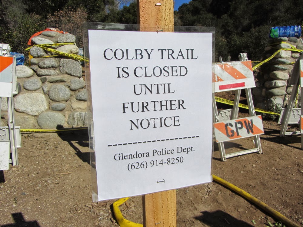
Colby Trail Closed – Jan. 18, 2014 |
COLBY TRAIL
Update 3-16-14: An official with the Glendora Conservancy said they are hopeful to reopen Colby Trail by May. There is still loose debris falling on the trail. They are also concerned with rogue hikers going off trail and damaging sensitive plant communities and creating soil erosion.
With permission from the conservancy, I was able to hike the closed trail and survey the fire damage. Read it about it in my blog post:
- Visit the Glendora Community Conservancy to learn more.
- See Conservancy Loss below.
- Visit the my Colby Trail Hike Description at Dan's Hiking Pages for trail updates
GARCIA TRAIL
Update 2-4-14: The City of Azusa has announced that because of the extensive damage to Garcia Trail and degrading conditions that will continue, L.A. County Fire and Department of Forestry has closed the trail indefinitely. The photos of fire damage to our beloved trail are quite telling. See presentation here: Garcia Trail Update (2-3-14)
See these official links for unfolding information and updates:
- City of Azusa website
- City of Azusa Facebook page
- Azusa Policy Department website
- Azusa Police Department Facebook page
- Photos of trail damage on Azusa PD Facebook
Other social networking sites with discussion regarding Garcia Trail (beware of some misinformed and nonconstructive comments):
 1-26-14 - Garcia Trail Damage. Photo from City of Azusa |
 1-26-14 - Garcia Trail Damage. Photo from City of Azusa |
The bottom line: It may take years for the mountainsides to be stabilized enough for Garcia Trail to be restored for safe usage.
- Mt. Bliss via Van Tassel Fire Road (Azusa)
- Mystic Canyon Trail & Lower Monroe Road to Summit 2760 and Summit 3397 (Glendora)

Colby Trail, the namesake of the Colby Fire, is on property owned by the Glendora Community Conservancy, which has held, managed, and stewarded the open space for more than two decades. The fire ravaged the environs surrounding Colby Trail. The losses of wildlife, plant communities, endangered species, and natural resources are immeasurable and uncountable.

Visit the my Colby Trail Hike Description at Dan's Hiking Pages for trail updates
Read San Gabriel Valley Tribune Stories:
- Conservation group creating Children’s Forest in Glendora
(2-1-14) - Fire Followers: Dazzling display of plants to follow California wildfires
(2-8-14)
My Story

When I turned on the news this morning at about 6:25 my heart sank. “Breaking News: Fire north of Glendora.” The images were horrifying. Wildfires are part of life, but when they occur next door, they invade and alter our reality.
I grab my camera and race outside, hoping maybe the newscast got the wrong city...maybe it's Glendale. Nope. A plume of smoke billows into the predawn sky. The orange glow of flames colors the ridgeline just a few miles east from my house in Azusa. I let out a cry that could wake neighbors. No, this can’t be happening to my mountains! I had just hiked in that area a couple weeks ago.


I wrestled with the thoughts of what my beautiful mountain will look like in months and years to come. These are my mountains, my trails, my backyard! Hiking Garcia Trail or Colby Trail will not be the same for many years. I’ve hiked a lot in burn areas—Curve Fire, Williams Fire, Morris Fire, Station Fire—and I know firsthand the devastating effects of wildfires. Well-meaning people try to console me by saying the fire causes seeds to germinate. That’s like telling a woman who lost a child that she is still fertile and can have more! Not much comfort!
I decide to leave work early and head for home at 2 p.m. My bus ride east on the I-10 provides some good views of the distant mountainside. The huge plume has dissipated into a smoky sky. Little white plumes rise from hot spots. Yellow super scoopers circle overhead but don’t appear to be attacking the fire. The news says 1,700 acres burned so far.


Farewell Tour

Environmental Loss

And people have misconceptions about ecosystems and fire suppression and the balance of nature. I posted a picture on Facebook showing the naked mountainside with this caption: “The environmental loss is horrible. I’m stunned that officials chose to just to let this ‘fuel’ burn.”
A good friend responded by saying: “In my opinion...if smaller fires didn't occasionally burn, then larger and much more damaging ones would take place due to overgrown fuels. Although, this is a tragedy...could it be a blessing as well??
This was my response:
Thanks for trying to find the silver lining. However, this fire is not a blessing at all. It's a tragic loss of beautiful native habit that will take many decades to recover. That the firefighting community uses the term “fuel” like military commanders refer to death of innocent people as collateral damage. But they are people...moms and dads, sons and daughters, people who laugh and cry and dream and worship...gone! We didn’t lose “fuel” and it certainly wasn’t overgrown. We lost a mature native plant community...laurel sumac, toyon, chemise, lemonade berry, bay, coast live oak, sugar bush, coastal sagebrush, brittlebush, yucca, honeysuckle, yerba santa, prickly pear cactus, bush sunflower, hollyleaf cherry, clematis, elderberry...and habitat for bear, mountain lion, bobcat, deer, coyote, fox, rabbit, squirrel, and numerous birds and reptiles. It’s all gone and it’s a horrible tragedy. See my Plants on Garcia Trail to see some of what we've lost.

Read San Gabriel Valley Tribune story by Steve Steve Scauzillo:
Fire Followers: Dazzling display of plants to follow California wildfires
See Trail Descriptions on Dan's Hiking Pages:
I'm a hiker who lives in Azusa (read your site for years--thank you!), and I was also shocked by the casual remarks of broadcasters I heard talking about the firefighters "just letting all that fuel burn" as a controlled fire "so they won't have to return anytime soon." I understand that controlled burns used to occur when the forest service had the proper resources, but these are precious places with trees and shade and greenery that are sorely needed for those of us in Los Angeles. If the idea is truly to burn it while they're here just so that they won't have to return, that seems so defeatist it truly grieves me.
ReplyDeleteWell said, Doug! I am pressing the Azusa city council to call for an investigation on how the fire was handled. You may consider raising your concerns also. It seems to me that the strategy should have been to save as much of our precious natural resources as possible and not use the fire as an excuse to burn more. The irony is that that vast majority of the acreage burned is within the city limits of Azusa and Glendora; only a very small portion was in the national forest. See this map:
ReplyDeletehttps://dl.dropboxusercontent.com/s/df80rrc966yv9ss/Operations_Colby_LiveMap.pdf?dl=1&token_hash=AAEzg0CJGBW94nqvFrynlGectEF__ffhv6bNTW3_WmuGpA
Personally, I am uncomfortable with the feds coming into our city and burning up our mountains.
As far as burning “fuel” to prevent other fires, in Sept. 2013 the Madre Fire burned at the mouth of San Gabriel Canyon in Azusa. In August 2009 the Morris Fire burned more than 2,000 acres immediately north of the Colby Fire. In 2002, the Williams Fire burned 37,240 acres to the immediate north and northeast. Do we really need ANF coming into our city and burning more?!
I'm not aware of the extent of the federal involvement with the Colby Fire, but I must say that in general, I was very impressed by the scale and execution of the operation. However, I completely agree that the strategy should have been to preserve greenery rather than use it as an excuse to burn more, and if that was indeed their strategy, it needs to be seriously reviewed, not swept under media hand-wringing over private property damage that is quickly forgotten in lieu of the next day's news. These mountains are a major resource that are cherished and experienced firsthand by those of us living here, not just some remote, pictorial backdrop for westsiders and downtown news agencies.
ReplyDeleteYes, the past ten years have not been good for the San Gabriels. Our current drought has me very worried for 2014.
ReplyDeleteHi Dan, Thank you for your extensive and detailed report on the Colby fire. I am in the process of writing about the GRM and found your blog during my research. The Garcia Trail in particular, we will all miss. Thanks again, Mark (2heeldrivin')
ReplyDelete