See Van Tassel Ridge via Fish Canyon Trailhead Hike Description on Dan's Hiking Pages
Big changes are coming to Fish Canyon and Van Tassel Ridge. Since 1999, this “goat trail” up and over Van Tassel Ridge into the Fish Canyon to bypass the quarry operation has provided a grueling access to Fish Canyon Falls. Now hikes to the falls are entering a new era as Vulcan Materials is diligently working on the new access trail that runs directly through the quarry. And when Vulcan begins to quarry rock from Van Tassel Ridge, this trail over Van Tassel will no longer provide access to Fish Canyon.

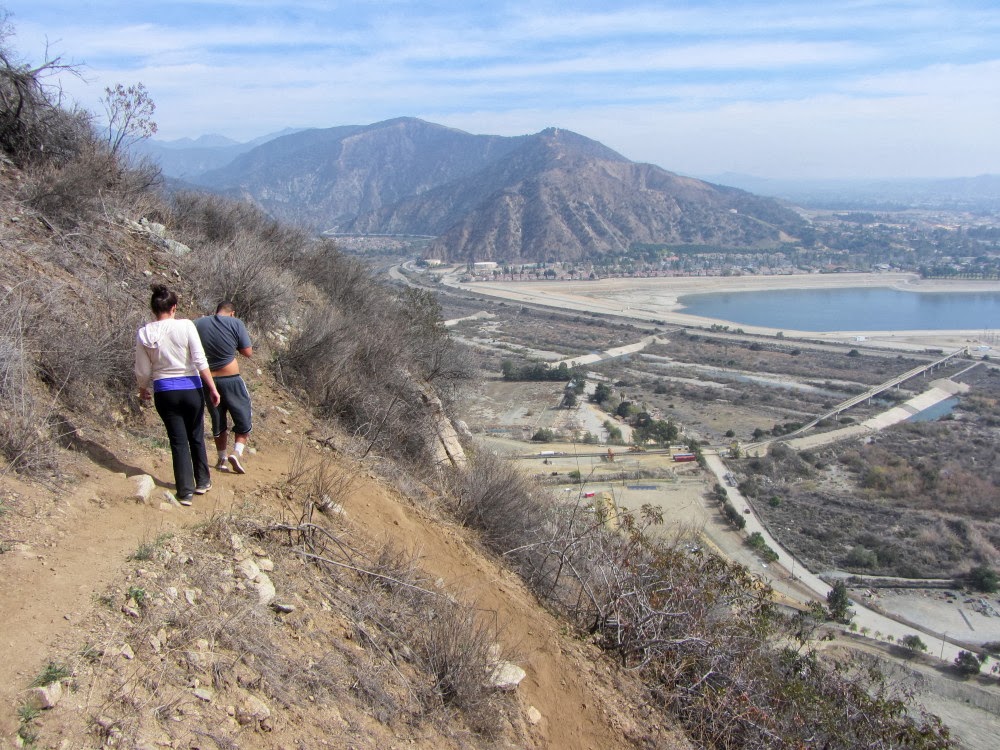
As an outspoken stakeholder for the future of Fish Canyon, I was invited by Vulcan representatives to tour the construction of the new access trail through the quarry this morning. And I have to say that I am pleased with how it’s shaping up. The photo on the right (taken from the hike to follow) shows the new one-acre parking lot dedicated to Fish Canyon Trail (square area on the right). It will hold more than 50 cars. Vulcan will be planting some trees around the parking area. The access trail proceeds to the left from the top corner of the lot and follows the shoulder of the creek to begin. At about two thirds through the quarry the trail transitions to a riparian corridor for the final approach to the National Forest boundary, 0.6 mile from the start. It will be open seven days a week! The conditions of Vulcan’s permit require that the access trail be completed by August 2014, but they are optimistic that it will be sooner. I am eager to post an announcement of a ribbon cutting ceremony! After the tour of the new access trail, I decided it would be an opportune time to revisit Van Tassel Ridge.

11:30 AM - Begin hike from the trailhead on Encanto Parkway in Azusa (often mistaken for Duarte since it is west of the river). It’s somewhat warm and I’m not really in a hiking mood. Maybe I’ll just walk up the trail a few minutes. With our record-low rainfall, everything looks parched. I encounter a group of about eight with some younger kids coming down. They didn’t go far. Soon I’m past the equestrian area and begin my climb up the steep mountainside. The dry and thirsty vegetation makes it feel more like August than February. There is nothing in bloom. Feels desolate. Pleasant breezes feel good.

I meet a lady who is resting. She asks how far to the falls. I tell her 4 ½ miles and lot of elevation gain on a really steep trail. I don’t think she quite understands. Shortly I encounter a young man and women coming down; they didn’t go far either. I meet another young man and women and they went all the way to the forest boundary (3.8 miles round trip with 1,400 feet gain). They wanted to go to the falls but they had enough. It’s interesting that there are so few people on this trail compared to the throngs that used to be on nearby
Garcia Trail before being closed by the recent
Colby Fire. I wonder where they are all hiking now.
I’m pleasantly surprised that the trail is in reasonably good condition. Plants are not intruding into the trail and I am quite comfortable in shorts. But it’s steep and narrow and eroded in some places. And there spots that require climbing up rocks. Certainly a good portion of those who climb Garcia Trail would not be comfortable at all on this trail.
Thick haze mutes the views and joins the parched vegetation to give this hike a depressing feel. This hike today is not scoring high on the enjoyment scale, but I’m not wired to stop without achieving a destination. So I trudge on. There are not even flowers to photograph. As I round the south-facing slope, Van Tassel Road comes into view to the west. Nearing the top, I encounter a man and women who are coming down. They didn’t go far. (These would be my last encounter for the day.)
12:50 - Diamond Head ridge (1.3 miles from the start). I decide to continue over the ridge into the jungle area. It’s a little greener than the west and south slopes, but still pretty parched. The poison oak is mostly dormant and does not hinder my advance. I have a short descent and climb.
1:00 - Vulcan Fence. - What pressed me to reach this point is a desire to get a view across Fish Canyon to toward the reclamation work Vulcan is doing on the mountainside. The mining plan that was approved by Azusa voters requires that Vulcan turn the 40-foot “Mayan” benches into 12-inch micro benches. Most of the work at this point has been to carve into the sheer rock face to create an angle of repose to hold the soil and plant growth. A section at the very top has been micro-benched and hydroseeded. From this vantage point I can also see a section of the mountainside burned by the September 2013 Madre Fire.
1:17 - Start back. As I traverse the jungle I am aware that many acres of this mature chaparral will be removed as “overburden” when Vulcan prepares to quarry the high-grade aggregate rock, which will be used in construction throughout the L.A. basin. Thankfully, much of this mining will be out of view from the human sprawl to the south.
Back at the ridge I follow the path east toward Diamond Head, but as I’ve observed before, the path ends in about 100 yards. I am hopeful that once the trail is cut off from proceeding over Vulcan property and into Fish Canyon, the trail to this point can be improved and maintain to provide a hike to Diamond Head. We’ll see.

Hiking down the steep, slippery trial is tedious as careful steps are required to keep my feet under me. Over on Van Tassel Road, I can see and hear heavy equipment being used by Edison for their project to construct new power towers. I can’t comprehend why trail users toss their plastic bottle down the slope. What pigs! I have solitude the entire way down. Some wild cucumber, a few tiny mustard flowers, and a single occurrence of wishbone bush provide some flowers after all, but far overshadowed by the parched vegetation of an extremely dry winter. And almost to the trailhead, some Douglas nightshade, tree tobacco, elderberry, mule fat, and golden currant provide some flowers to end the hike.
2:32 - End hike. There are four cars in the parking lot (there were eight when I started). Perhaps these belong to folks who have taken the long slog to Fish Canyon Falls.
Epilog - Not the greatest hike but good to revisit the trail and to update my hike description. And it was good to get a perspective on the progress Vulcan is making. I was thankful that the route was mostly brush free and that my feet stayed under me on the tedious downhill. I encountered only about 15 people in five parties; that’s pretty sparse. And three miles round trip with 900 feet in evaluation gain; that’s good exercise.

 See my blog post Van Tassel Ridge Hike - March 31, 2012
See Van Tassel Ridge via Fish Canyon Trailhead Hike Description on Dan's Hiking Pages
See Fish Canyon Falls Hike Description on Dan's Hiking Pages
See my blog post Van Tassel Ridge Hike - March 31, 2012
See Van Tassel Ridge via Fish Canyon Trailhead Hike Description on Dan's Hiking Pages
See Fish Canyon Falls Hike Description on Dan's Hiking Pages