Summit 2843 stands predominantly over Azusa near the mouth of the San Gabriel Canyon. Most valley dwellers have probably never thought about the peak as it appears to be just another welt among the undulating sprawl of the San Gabriel Mountains. And it eludes most hikers since there is no formal trail to the unnamed summit, and if one is driving up Highway 39 to go hiking, there are many more high-profile destinations from which to choose. But I love this little pinnacle and enjoy the solitude of its trails. It is my peak.
With the trailhead being only 10 minutes from my home in Azusa, Summit 2843 and the routes leading to it have become some of my favorite “scrappy hikes”—that is, a hike done on scrap of carved-out time when my schedule is full. But on this occasion, I was able to give it primetime billing on a Saturday. It’s been three years, almost to the day, since I last hiked it, and I have been looking for an opportunity to hike with my friend Tom. This hike was ideal. The route starts just past Morris Dam and offers several options for climbing 1,543 in elevation gain, in the range of 4 to 4.5 miles round trip.
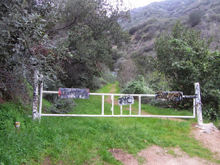
7:20 AM - Begin hike. Tom and I skirt the locked vehicle gate for 2N28 and begin our saunter up the old Silver Fish Fire Road. It’s cloudy and cool with a rainstorm forecast for tomorrow. While the deciduous trees and shrubs are mostly leafless, winter rain has greened the grasses and is bringing life back to the chaparral. The morning dew adds freshness to everything. Starting at the trailhead with the carpet of weedy oxalis and its little yellow flowers, I immediately begin to take pictures of each species in bloom. Tom becomes curious about the names of the various plants and I enjoy introducing him to them. He’s an eager learner and practices his nearly acquired plant names as we encounter multiple occurrences of them along the trail. The mountain lilac shrubs and other ceanothus are covered with lavender and white blossoms and create a distinctive hue to the richly textured chaparral. The tender green branches of wild cucumber vines are climbing to life and are covered with tiny white flowers.
7:53 - Junction with ridge route. It’s been a slow but pleasant half mile. One route heads straight up the ridge following an old fire break, but we choose to stay on the abandoned fire road as it traverses into Water Canyon. It’s been more than five years since I’ve been in Water Canyon, so I’m eager to check the route conditions. The heavy rain of 2005 caused some significant damage, and since then there’s been issues of fallen trees, poison oak, and other obstructions. A salamander crawls through the green grass. We stop occasionally to flick off ticks. We encounter more newts on several occasions, usually in pairs. Tom and I thought salamanders were usually near streams, so we are a little surprised to find them here, a good 100 vertical feet above the creek. Some of the poison oak is sprouting its tender leaves after its winter hiatus. Tom keeps practicing plant names as we continue adding new ones.
9:08 - Reach the western end of the road before it switches back. I’m pleasantly surprised to find that the thorny-tree forest that had been obstructing the path is gone. And around the corner, the huge poison oak patch that had blocked the route is gone too. It looks like a dozer has worked on this section of the old road in the last year or two, but I don’t know how it would have gotten here. The abandon fire road between here and the trailhead has many years of being reclaimed by nature. Heavy equipment would have had to come from the other direction.
So far this morning the blooming plants we have encountered include oxalis, mulefat, white and lavender ceanothus, wild cucumber, hollyleaf cherry, wishbone bush, sugar bush, canyon sweet pea, a purple weed, two-tone everlasting, felt-leaf everlasting, California poppy, and lupine (just one lone bud). We’re having a great time. And there is such serenity here. It blows my mind that we have the whole mountain to ourselves.
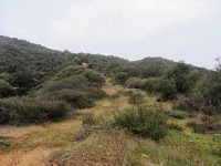
9:51 - Ridge junction. The grade up to this point has been very pleasant. Now comes the fun part in climbing the steep ridge. We take a twenty-minute break and enjoy good conversation and splendid scenery. As we climb west up the exposed ridge, we are thankful for cool temps and cloudy skies. Chirping birds provide a pleasant soundtrack. We encounter our first new blossom of California buckwheat.
10:46 - Upper occurrence of the fire road. Dozer tracks leave me wondering how the heavy equipment got up here. I know of no access point from the south. We continue to climb the ascending/descending ridge.
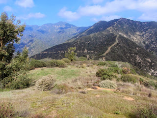
11:18 - Upper Ridge. The broad green-grass-covered crest offers a splendid panorama, howbeit, muted by haze. The sun has finally broken through clouds. The highpoint looming to our immediate south has Tom thinking we are almost there. I have to break the news to him that we still have another 0.4 mile to go. We climb south to the highpoint and continue along the undulating ridge. It’s peaceful up here. The Baldy high country to the east finally breaks through the clouds. It’s been a mild winter and there is hardly any snow up there. We round the crescent, make our final steep climb of 100 vertical feet, and make our approach to our destination.
12:05 - Summit 2843. Wow, we’ve made it! Nearly five hours to hike 2.5 miles…that’s truly the definition of a saunter. This is my sixth visit to this peak, and every outing has been unique. My first visit was with my buddy Drew 10 years ago May. The views from here can be great but today it’s pretty hazy. We sit and have some lunch. The view west toward Vulcan’s mining activity on Van Tassel Ridge is a good discussion starter. Before leaving, I give Tom a guided tour of the couple dozen peaks within view.
1:20 - Leave summit. We retrace our steps down the ridge. The sun feels good. At 1:50 we transition from the upper ridge to our eastward descent. Our steps are careful in the steep sections. We cross the upper occurrence of the fire road at 2:05 and continue down the ridge. We reach the lower occurrence of the fire road at 2:25 and continue down the ridge rather than turning left and retracing our steps through Water Canyon. This is new territory for us today. The descent is comfortable. We enjoy good conversation and rugged scenery.
2:40 - Reach the beginning of the steep section. Here the path down the old firebreak gets crazy steep and slippery. Tom leads the way as we carefully negotiate each step. Trekking poles would really be helpful about now. Midway down we are treated to a patch of golden poppies that beg to be photographed.
2:56 - Back on Silver Fish Fire Road. Now for a comfortable stroll for our last half mile. A young mustard sports its yellow flowers. I am happy to find a couple bright orange blossoms of bush monkeyflower as the vanguard of many more to come. We wind in and out of the sun and shade. As we near the highway, trash and graffiti remind us that some humans don’t belong on this planet.
3:20 - End hike, exactly 8 hours from the start.
Epilog - What a thoroughly enjoyable outing! Splendid scenery, rugged beauty, wonderful serenity, pleasant weather, green grass, lovely wildflowers, a beloved peak, and great company. God is good. Life is good.
NEXT > Summit 2843 via East Ridge, San Gabriel Canyon - Jan. 1, 2016
PREVIOUS > Summit 2843 via San Gabriel Canyon Hike - Feb. 24, 2013


No comments:
Post a Comment