A big storm beginning the third and final month of winter dumped tons of snow on our mountains this weekend dropping below the 3,000-foot level. So when I arose and saw the sunshine, blue skies, fluffy white clouds, and snow on the nearby mountain slopes, I knew I had to head into the mountains. I wasn’t sure where I would hike, but I figured I’d jump on Hwy 39 and head up the canyon to see where I would end up.
11:30 AM - Leave my house in Azusa and head north on Hwy 39 into San Gabriel Canyon. The beauty of the day and surrounding scenery captivates me. I open the sunroof to experience the brisk air. Lots of water in
Morris Reservoir but not over the spillway. Across the canyon to the east I see snow on Glendora Mountain (3322’)

and consider it as a possible destination for today. I stop at turnouts several times en route and take pics. Billowing white and gray clouds loom over the high country.
11:59 - Reach
East Fork Road and turn right (east), crossing the bridge.
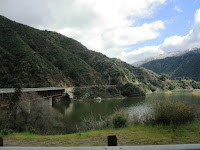
Lots of water backed up behind San Gabriel Dam and under the bridge. Continue to stop and take pictures along the way. Photograph the white blossoms of hoary-leaved ceanothus;


the blooming shrub covers the mountainsides. The river is rushing.
12:16 - Turn left on
Shoemaker Canyon Road and drive the two miles to the trailhead. I love the aromas and beauty after a storm. It’s 48 degrees but feels colder. The Heaton Flat parking lot looks full in the canyon below. I drive back to East Fork Road and turn left (east) and head to the Heaton Flat parking lot. It is completely full and cars are parked down the road. Where are all these people hiking to? The Bridge to Nowhere? I sure wouldn’t do it in this weather. Maybe they are prospecting. Clouds are threatening. Continue on my way.
12:56 - Turn left on
Glendora Mountain Road (GMR) and begin my ascent southwest into mountainsides dusted with snow. Wow, it’s beautiful here. Stop occasionally to take pictures. Make a snowball.
1:18 - Reach
Glendora Ridge Road junction at the ridgeline and stop to enjoy the vistas with others. Back in the car, I head west on GMR.
1:38 - Arrive at the trailhead for Glendora Mountain (road marker 6.50), on a narrow ridge dividing Little Dalton Canyon to the south and Persinger Canyon to the north (a tributary of San Gabriel Canyon). The car thermometer reads 43 degrees, but it feels warmer than when it read 48. I haven’t hiked to this summit since 2001 so am eager to revisit it.
Glendora Mountain Hike
1:40 PM - Begin hike. The path starts on the south side of the road and heads west up a firebreak. It’s a bit steep but not bad. A Spanish broom hosts a few yellow blossoms. An inch of melting snow crunches beneath my boots. Fresh coyote tracks mark the route.
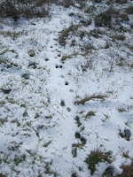
Brisk air invigorates me. In seven minutes I reach a knob (3311’), the first of about five bumps en route along this undulating ridge. There are a lot of lupine plants along the path, and one eager plant displays its purple flowers in anticipation of spring coming in one month.

Motor vehicles on the road just below contribute to the soundtrack for this hike.
The ridge bends to the south and the summit is in view, less than a mile away. Clouds veil 10,000-foot Mt. Baldy to the east, which certainly is buried with snow. San Gabriel and Morris reservoirs soon come to view in the canyon below. I roller-coaster along the ridge now heading south, following the tracts of the coyote. Great views in all directions. The snow gives the scenery a very different feel.
2:23 - Glendora Mountain (3322’), about 1.0 mile and a total rollercoaster gain of about 378 feet from the start. I enjoy the unobstructed 360-degree panorama.

Lots of familiar peaks in view remind me of years of exploring these splendid mountains just above my home. A couple months from now this site will be colored purple with abundant lupine. Patchy clouds cast modeled shadows on the surrounding mountains. No cell reception. Enjoy leafing through the summit log housed in a baggy in a red tin can that is tucked in a pile of rocks. The last visitor was here two days ago and noted that it was raining. This peak doesn’t get many visitors and most of them have not been standing here in snow. Well, it’s getting cold and the clouds are threatening to dump something on me.
3:00 - Leave Summit. I follow my footprints in the snow and enjoy the snow-covered panorama to the north. My hands are cold but I don’t bother getting out my gloves. The evidence of fire abounds.

The Morris Fire, which began on August 25, 2009 and burned more than 2,100 acres, was stopped on this ridge from burning further east. It didn’t get much media attention since the Station Fire to the west erupted the next day and went on to incinerate 250 square miles of the San Gabriel Mountains. On the final descent I stop and photograph some more plants.

3:38 - Finish hike. The car thermometer reads 51 degrees. I drive down the meandering GMR toward Glendora, stopping several times to soak in the picturesque scenery.
 Epilog
 - Another rewarding experience in the San Gabriels! For this outing, the car trip was as much a part of the experience as the hike. I love my mountains!

 See Hike Description at Dan’s Hiking Pages
(Detailed trail guides include driving directions recommended season, map, notes, links, and photos)
 Related link on Dan's Hiking Blog:


 and consider it as a possible destination for today. I stop at turnouts several times en route and take pics. Billowing white and gray clouds loom over the high country.
 Lots of water backed up behind San Gabriel Dam and under the bridge. Continue to stop and take pictures along the way. Photograph the white blossoms of hoary-leaved ceanothus;

 the blooming shrub covers the mountainsides. The river is rushing.


 Brisk air invigorates me. In seven minutes I reach a knob (3311’), the first of about five bumps en route along this undulating ridge. There are a lot of lupine plants along the path, and one eager plant displays its purple flowers in anticipation of spring coming in one month.
 Motor vehicles on the road just below contribute to the soundtrack for this hike.

 Lots of familiar peaks in view remind me of years of exploring these splendid mountains just above my home. A couple months from now this site will be colored purple with abundant lupine. Patchy clouds cast modeled shadows on the surrounding mountains. No cell reception. Enjoy leafing through the summit log housed in a baggy in a red tin can that is tucked in a pile of rocks. The last visitor was here two days ago and noted that it was raining. This peak doesn’t get many visitors and most of them have not been standing here in snow. Well, it’s getting cold and the clouds are threatening to dump something on me.
 The Morris Fire, which began on August 25, 2009 and burned more than 2,100 acres, was stopped on this ridge from burning further east. It didn’t get much media attention since the Station Fire to the west erupted the next day and went on to incinerate 250 square miles of the San Gabriel Mountains. On the final descent I stop and photograph some more plants.


