 See Echo Mountain Hike Description and Rubio Canyon Hike Description on Dan’s Hiking Pages
A rain storm that started on Christmas evening and carried over to the next day cleared up for an absolutely gorgeous day for hiking. Thankful for a week off from work between Christmas and New Years, I was eager to hit the trail for a final hike to conclude 2010. With all the rain we have had, this is certainly a great time to visit a waterfall. But the exceptional visibility drew me to a high place instead—Echo Mountain above Altadena.
On my drive from Azusa to Pasadena, the beauty of the mountains after the rains is striking. I find a place to park on Lake Avenue near the Cobb Estate trailhead.
 12:31 - Begin my hike. The weather is perfect...sunny, clear, low 70s. I love the greenness of everything! On the Sam Merrill Trail, I begin my 2.5 mile ascent. Lot of people on the trail. My pace is brisk. I am captivated by the beauty of the surrounding mountains and the ever expanding view of the human sprawl below. Virtually nothing in bloom. Red toyon berries add a splash of color. I am peeved by the thoughtless dog owners who believe that they are exempt from leash laws and common courtesy.
12:55 - One-mile marker. Really enjoying the hike. Sun feels good. Sky is so blue. Views are great. Chaparral is fragrant. Pass the two-mile marker at 1:23. Further up in Las Flores Canyon now as the city views narrow. Can hear water flowing deep in the canyon below. Can see all the way to Catalina Island.
 1:41 - Arrive at the old rail bed junction. My thinking is to head north to the Cape of Good Hope, but first I’ll take a quick look around the Echo Mt. ruins. Snap pictures of the various signs, machinery, and foundations. Others are enjoying the site as well. As I stand on the grand steps of the historic Echo Mountain House, I imagine ladies with parasols and men in derbies...100 years ago. I’ve been here four times before, so I’m not sure why my inclination to again explore this historic site trumps a “quick” visit. I yell through the echo phone, and yup, there’s still an echo.
 I wander over to the site of the chalet and continue following the trial east toward Rubio Canyon to get a pic of Leontine Falls. I’ve explored some of these trials before, but I don’t recall where this one leads. A ways down the trail, I sit on a rock and have some lunch while enjoying an excellent view of the old incline tram bed and the southland beyond. I relish the solitude (I’m sure that the vast number of Echo Mt. guests don’t venture over here). At 2:37 I continue down the trail, thinking that it probably bends north up canyon, if my recollections are correct. But it continues to zigzag east into Rubio Canyon. I finally decide that I’m not going to climb back up to Echo Mt., so I sure hope this trail ends someplace favorable! It bends south and shortly I see in the distance that the trail intersects the incline tram rail bed.
 3:00 - Arrive at the incline tram rail bed. I’ve been here before, only that time I had climbed from the bottom. A route clearly heads down, but I don’t readily discern a route heading up. I begin my steep descent. The path zigzags down the old tram bed. My steps are guarded. I take pics of railroad remnants. Bypass the chasm which had been spanned by “Macpherson Trestle.” Descend the tram bed through “Granit Gorge.”
3:33 - Arrive at Rubio Canyon Trail. Of course, before I turn south to head home, I’m compelled to boulder hop upstream the quarter mile to visit the waterfalls. The creek is flowing briskly. My pace is slowed by finding the route, fording the creek numerous times, and negotiating the foliage that has grown since the creek bottom was laid bare in the October 2004 storm. At several points I pondered if it is even wise to proceed. But I pressed on. A father and son pass me as they head down.
 3:52 - Arrive at Ribbon Rock and Moss Grotto Falls. What a beautiful site! Direct sunlight still lands on the upper falls. I know I can’t linger long because sunset is in less than an hour. I explore the area and take lots of pics. Been here four times before...twice before the falls were covered with rocks, and twice after the October 2004 storm restored the falls.
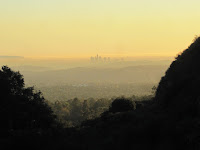
 4:04 - Leave the falls. I’m more confident now negotiating the boulder-strewn creek bed. I arrive back the old pavilion site at the lower end of the incline tram at 4:20. Beyond the ruins I pick up the main trial and am relieved to be on nice path. The sun still alights on sections of the canyon. The trail is newly washed out in several spots making for some dicey moments. The creek is far below. My pace is casual as I soak in the beauty of the canyon at day’s end. The distant downtown L.A. skyline silhouetted in an orange sea of haze emerges through the V-shaped canyon mouth.
4:42 - Arrive at the Rubio Canyon Trail trailhead at the corner of Rubio Vista Road and Pleasant Ridge Drive in the middle of a residential neighborhood. The warm glow of the setting sun is beautiful. Now for the task of navigating a walk back to my car on Lake Avenue. The map I have with me is virtually useless. I walk down the street and once on Rubio Canyon Road, I discover Altadena Crest Trail running alongside the drainage wash. Looks like it’s heading in the right direction, so I give it a try. Shortly I meet a couple walkers who confirm that this route will take me where I want to go. In a few minutes it transitions into a creek bed and in a few more minutes I am pleased that it delivered me to the beginning of Sam Merrill Trail.
5:13 - End hike, back at car. What a thoroughly enjoying outing! Fantastic weather, dramatic scenery, green hillsides, historic ruins, a gushing waterfall, and a serendipitous adventure with a favorable ending!
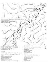
 Map Note: At the Rubio Canyon trailhead, a white box sitting against a sign post contained copies of a line map (provided by Paul Ayers). One side showed Rubio Canyon Trials, and the other side showed Mt. Lowe Railway Trails. From it I learned that the trial I took from the chalet is Chalet Trail, then turns south and becomes Old Echo Mountain Trail, and the final piece is Incline Trail.
 See blog posts from other hikes in Rubio Canyon:
See Echo Mountain Hike Description and Rubio Canyon Hike Description on Dan’s Hiking Pages
:


