Big Sky Country exceeded my expectations! Several short excursions into the surrounds of Billings, Montana provided an enjoyable taste of an outdoors that is distinctly different from my local San Gabriel Mountains. My son and family moved to Billings in July and so my wife and I were eager to visit them in their new setting. Hiking was not necessary part of the plan for the week, but opportunities to hit the trail are always on my radar. And after all, the slogan for Billings is “Montana’s Trailhead.”
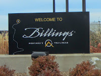
And the weather was amazingly cooperative. Usually by November, Billings can be snowy, but this was the warmest autumn since the 1930s. Our daytime highs ranged from the mid-50s to the mid-60s...temperatures that are quit manageable for this SoCal native.
Here are some highlights of my four outdoor excursions.
Wild Bill Lake - Tuesday, November 4
My son wanted to treat the family to a road trip that featured a noteworthy local destination, so he took us to Red Lodge. This small community is 60 miles west of Billings and is the gateway to the Beartooth Mountains. It has an old town feel with interesting shops and restaurants and lots of old-west history. After we arrive at the Visitor Center we decide that Wild Bill Lake will be a fun place for family. A 10-minute drive up West Fork Road delivers us to the Wild Bill Lake Picnic Area in the Custer National Forest, at an elevation of about 6,800 feet.
Wild Bill Lake was built by William “Wild Bill” Kurtzer as a commercial recreation enterprise in 1902. It was stocked with whitefish, had rental boats, and featured a concrete dance platform. Today a pleasant trial of about a half mile circles the lake and hosts several fishing decks.

Cloudy skies and 48 degrees are strong motivators to down our “picnic” lunch quickly and hit the trail. Our party of three young children and four adults start our “hike” at 1:56. A dense pine forest surrounds us and a ridgeline accented with a massive outcropping rises 865 feet above us. The small lake is covered with a thin sheet of ice. We have fun tossing pebbles and watching them skip across the ice. Our walking and tossing helps warm us up. From a fishing deck on a peninsula, we are intrigued to see the fish swimming in the frigid water below the ice. Soon the sun peeks out on a few occasions. We saunter around the lake thoroughly enjoying the rugged scenery. We finish the hike at 2:56, one hour from the start. What a delightful outing!

Back in downtown Red Lodge we stroll along the sidewalk and poke in various shops. Our day ends with a yummy meal at Bogart’s Restaurant.
Four Dances Natural Area - Wednesday, November 5
Today my son had pressing responsibilities at work and the ladies planned an outing with the kids to Target and Costco. It was the perfect opportunity for me to go hiking. I decided on Four Dances Natural Area, which is up on the bluffs in southeastern part of Billings. In 1999, the BLM acquired 765 acres of undeveloped open space to preserve as public land. According to the trailhead sign, “The property is native sagebrush/grassland, ponderosa pine in the rocky outcrop area near the river cliffs, and Yellowstone River cottonwood riparian.”

From Billings, I head east on I-90, cross the Yellowstone River and turn off on exit 452. I turn right on Highway 87 and almost immediately turn right unto Coburn Road. A short 0.7 mile brings me to the first trailhead and a path that leads to the old cabin site of Will James (1892-1942), cowboy, cattle rustler, author, artist, and stuntman. Back in the car, another 0.7 mile brings me to the turnoff for the next trailhead, where I turn right and drive the short dirt road to the parking lot. A nice kiosk presents a map and some information.
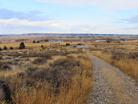
11:50 AM - Begin hike. The path heads west as it gently ascends the rolling grassland. Temps are in the low 50s but the warm sun makes it pleasant. The view of undulating yellow prairie dotted with islands of trees stretches to the horizon. The expansive landscape is wonderful. The path bends left into a slight draw and rises to a junction.

11:56 - Four-way junction. The map shows it as a T-bone junction, so I’m not sure which route isn’t shown. The sign points right (east) for the River Access and straight for the Scenic Overlook View Area. I go straight and in about 100 yards reach the crest with a partial view northwest toward downtown Billings. The path heads north and south and I choose south. Another couple hundred yards brings me to the overlook area with benches and interpretive signs. The scenery is grand with striking views of the surrounding rimrocks,

the river, and the city.
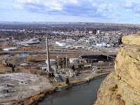
I climb down to an outcropping and enjoy a breathtaking perch.
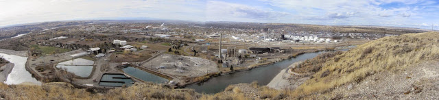
Back up on top, I follow the path southeast through the sprawling grassland about 100 yards from the edge. I don’t know what this tall, dry grass is, but it fits the description of “amber waves of grain.” Then there are the “spacious skies.” The big blue sky is accented with an assortment of fluffy and wispy clouds. I’m intrigued that as far as I can see, the horizon encircles me 360 degrees. This is truly “big sky country.” Nothing in SoCal really compares to this (and visa versa).
Occasionally a side path heads over to a nice bench placed strategically near the rim. There are five of them spaced out over about a half mile. I sample each bench and enjoy the varied vistas. The mighty Yellowstone River glistens in the afternoon sun. I’m captivated with the expansive scenery and huge sky. A majestic raptor soars overhead

(it may be a peregrine falcon that is described on the interpretive sign).
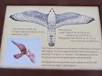
The sandstone cliffs remind me of cowboy movies. This is simply grand!
1:16 - Reach my furthest point south. The path continues ahead to an array of antennas, and beyond would be Coburn Road. I turn back, exploring more of the cliffs en route. I don’t think I’m afraid of heights, but I do get tingly feet when I’m close to the edge. Strong breezes increase the angst of standing near the precipice. The cliffs are tiered, but finding a route down to the middle level will have to wait for another trip.
2:14 - Back at the scenic overlook. I venture west down a short path to another dramatic perch on the sandstone cliffs. I add a face to a circle of rocks.

The biggest city in Montana spreads out before me. I can almost touch the river 560 feet below me.

The scenery is stunning. And no one is here…I get it all for myself! I guess that shouldn’t surprise me. There are times while hiking in my beloved San Gabriels Mountains surrounded by a population of 15 million, I enjoy amazing solitude.
I wander back up to the scenic overlook area and retrace my steps north to the junction, then continue north toward a communication antenna.

It’s fun to look back across the chasm to the cliff were I was a few minutes ago. Past the antenna I gently descend to another vantage point and enjoy some more splendid views and dramatic scenery. The breeze is cool.
2:53 - Head back. Past the antenna I veer left and take a narrow path east to interest the “River Access” route. I turn right and two minutes delivers me to the four-way junction. My pace is slow as I retrace my steps back to the trailhead savoring the beauty of this special place.
3:05 - End hike. It’s a pleasant 61 degrees. An easy walk of probably 2.5 miles can barely be considered a hike, but what a thoroughly enjoyable outing! Exceeded my expectations.
Zimmerman Park and the Northern Rimrocks - Thursday, November 6
My wife and I have the morning free before rendezvousing with my son’s family later on, so we decide to do some sight seeing. Minutes from our accommodations we drive up Zimmerman Trail. This windy road heads north in a small canyon to the top of the rim overlooking Billings.

The road was built by brothers Joseph and Frank Zimmerman in 1891 as a means for Joseph to move his sheep back and forth from his homestead below to the spring on top of the rimrocks. In 1938, the Rotary, Kiwanis, and Lions clubs, and a campaign committee, donated the $750 required to purchase the tract of land (Zimmerman Park) and the right-of-way for the road to the top. These properties were subsequently deeded to Yellowstone County.
At the top of Zimmerman Trail we turn left on Hwy 3 and in quarter mile turn left into the parking lot. Zimmerman is similar to Four Dances with grassland on top and ponderosa pine (the state tree of Montana) adorning the rocky cliffs.

There is an extensive web of trails providing miles of possibilities.

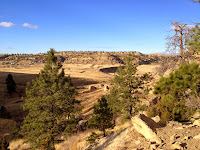
10:48 - Begin our walk on the paved path about 80 yards to an informational sign surrounded by grassland. The attractive kiosk provides a brief history of the Zimmerman brothers and their settling of the area. We walk another 200 yards south to the rim. Wow, this is dramatic scenery!, We wander around and soak in the varied views and topography dominated by steep cliffs, huge boulders, pine trees, and the west end of Billings spreading out below us. The stiff breeze is cold so my wife is eager to leave. We stroll back on a different route before retracing our steps to the kiosk and then to the parking lot.
11:24 - End walk.

What a splendid natural park! This truly is a jewel in the billings park system being just minutes away from residential areas and offering hikers, bikers, joggers, and dog walkers a superb venue to enjoy the outdoors.
Unfortunately there is no restroom, so we jump in the car and drive east along the rim about seven minutes to the cute little “international” airport to use the facilities. Imagine driving to an airport just to use a restroom. Back at home I don’t even like driving to LAX to catch a plane!
After our potty break we visit the Yellowstone County Museum, which is there at the airport. It’s small but has an impressive collection of fine displays and artifacts featuring local history.
We then we drive across the highway to the parking area along the rim. I wander around and enjoy some splendid views and dramatic scenery.

Across the valley I get a good look at Four Dances where I was yesterday. Downtown Billings is pretty flat with only three modest high-rises (20 floors tops) attempting to provide a skyline.

I climb down to a massive block perched on the side of the cliff. A 14-inch fissure separates it from the main rimrock.
I can’t help but to ponder the scene if this bad boy decided to tumble town upon the houses below. (Later I found a
news clip showing that these house-size boulders do indeed fall). I’m intrigued by the rimrocks and can see how this fascinating topography could provide the adventurer with many outings of exploration.
Riverfront Park - Saturday, November 8
Our week in Billings is coming to an end as we will board a plane late this afternoon. I decide I have time for one final jaunt in sampling the varied outdoor offerings of this city. It’s a brisk 39 degrees and I need to clear ice from the car windows. I pull out at 8:05 for the 8-minute drive to where South Billings Blvd. crosses the Yellowstone River. Before turning into the park, I drive across the bridge to get a view of the river from above. As a SoCal guy, the concept of a big flowing river fascinates me. The river is at least 100 yards wide and flowing briskly.
Back in the car I re-cross the bridge and turn right into Riverfront Park. I first drive through the park past Lake Josephine to a small parking area near Cochran Pond about 0.7 mile. There are two cars parked here. A sign with a map gives me the overview of the park.

It’s peaceful here and the frigid air and leafless trees punctuate the changing seasons. An interpretive sign tells about Joseph Cochran who settled here in 1877 as the first white settler near present-day Billings. A couple joggers pass by.
I drive back to Lake Josephine and park near the east end. A man in a kayak glides across the sparking blue lake. A pair of nosey geese flies overhead. I cross the small footbridge

that spans the channel that connects Lake Josephine and Cochran Pond, and head south on the paved path. Some shrubs still have a remnant of amber leafs amidst the leafless trees and yellow grass. My botanical skills are so narrow to plant communities of SoCal, I recognize nothing here by name. Just past Beaver Pond I veer left unto a narrow dirt path and continue south toward the river. I’m really enjoying the brisk air and the autumn beauty. The sound of the river grows. There are fresh deer tracks in the sand. Off trail now, I pick my way to the riverbank.
8:59 - Yellowstone River. What a splendid scene! There is so much beauty here. I think I officially love Montana. The river is wide and wild. There is a whitewater section in the middle where the river flows around a sandbar.

I video myself putting my hand into the icy water to experience the river (can one say he or she has been to the river without actually touching it?). I imagine that this riverbank scene would not be much different than how Lewis and Clark experienced it in July 1806 (aside from leafless autumn trees and the nearby bridge with traffic noise). I explore around a little. Leaves crunch beneath my feet…oh, I recognize these, they look like Fremont cottonwood (checking an online guide after getting home, I found that the tree is probably plains cottonwood,
Populus deltoides).

There’s a network of paths so I take a different route back to the paved trail and retrace my way back.
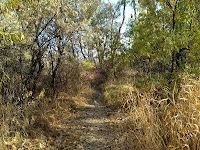
9:32 - Fishing walk. It’s 42 degrees. What a thoroughly pleasant outing! I’m so glad I decided to roll out of bed and venture into the cold for a last foray into the splendid outdoor spaces that grace this city. I am, however, a little puzzled. There are 105,000 people living in this city; I would think that more of them would be out walking or jogging in a beautiful park like this on a Saturday morning.
Epilog - From a glassy mountain lake, to golden prairie and towering rimrocks, to serene ponds and a roaring river, my samplings of some natural treasures that surround the Billings area were thoroughly rewarding. And I didn’t mention playing disc golf at Diamond X Disc Golf Course at Phipps Park on Monday. It’s the most amazing and challenging disc golf course I’ve ever experienced. We played only six holes, but it was so fun climbing around the base of the rimrocks searching for the tees, the holes, and our discs!

It was definitely more of a hike than disc golf. I am eager to go back and conquer the beast.
I really can see how Billings, Montana could be a suitable home for hikers. And the Beartooth Mountains are only an hour away, and they provide 12,000-foot peaks for one’s climbing pleasure! I look forward to my next trip to Big Sky County, or AKA, The Last Best Place.
 See Dan's Hiking Pages

 And the weather was amazingly cooperative. Usually by November, Billings can be snowy, but this was the warmest autumn since the 1930s. Our daytime highs ranged from the mid-50s to the mid-60s...temperatures that are quit manageable for this SoCal native.


 the river, and the city.
 I climb down to an outcropping and enjoy a breathtaking perch.


 (it may be a peregrine falcon that is described on the interpretive sign).
 The sandstone cliffs remind me of cowboy movies. This is simply grand!


 The biggest city in Montana spreads out before me. I can almost touch the river 560 feet below me.
 The scenery is stunning. And no one is here…I get it all for myself! I guess that shouldn’t surprise me. There are times while hiking in my beloved San Gabriels Mountains surrounded by a population of 15 million, I enjoy amazing solitude.
 It’s fun to look back across the chasm to the cliff were I was a few minutes ago. Past the antenna I gently descend to another vantage point and enjoy some more splendid views and dramatic scenery. The breeze is cool.


 The road was built by brothers Joseph and Frank Zimmerman in 1891 as a means for Joseph to move his sheep back and forth from his homestead below to the spring on top of the rimrocks. In 1938, the Rotary, Kiwanis, and Lions clubs, and a campaign committee, donated the $750 required to purchase the tract of land (Zimmerman Park) and the right-of-way for the road to the top. These properties were subsequently deeded to Yellowstone County.
 There is an extensive web of trails providing miles of possibilities.


 What a splendid natural park! This truly is a jewel in the billings park system being just minutes away from residential areas and offering hikers, bikers, joggers, and dog walkers a superb venue to enjoy the outdoors.

 I climb down to a massive block perched on the side of the cliff. A 14-inch fissure separates it from the main rimrock.


 It’s peaceful here and the frigid air and leafless trees punctuate the changing seasons. An interpretive sign tells about Joseph Cochran who settled here in 1877 as the first white settler near present-day Billings. A couple joggers pass by.


 that spans the channel that connects Lake Josephine and Cochran Pond, and head south on the paved path. Some shrubs still have a remnant of amber leafs amidst the leafless trees and yellow grass. My botanical skills are so narrow to plant communities of SoCal, I recognize nothing here by name. Just past Beaver Pond I veer left unto a narrow dirt path and continue south toward the river. I’m really enjoying the brisk air and the autumn beauty. The sound of the river grows. There are fresh deer tracks in the sand. Off trail now, I pick my way to the riverbank.


 I video myself putting my hand into the icy water to experience the river (can one say he or she has been to the river without actually touching it?). I imagine that this riverbank scene would not be much different than how Lewis and Clark experienced it in July 1806 (aside from leafless autumn trees and the nearby bridge with traffic noise). I explore around a little. Leaves crunch beneath my feet…oh, I recognize these, they look like Fremont cottonwood (checking an online guide after getting home, I found that the tree is probably plains cottonwood, Populus deltoides).


 It was definitely more of a hike than disc golf. I am eager to go back and conquer the beast.


