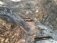
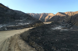
When I got home on Thursday evening, June 23 and saw the mountains and began to see the fire reports and news stories, I was numb. At about 7 p.m. I drove over to nearby Duarte to see what I could see. Encanto Parkway was blocked off so I meandered through the residential streets a little further west and north, but sheriff deputies had the streets near the mountainside closed off. I headed east on Royal Oaks then north on Melcanyon Road and arrived at the intersection of Brookridge at the base of the mountainside. The burn area loomed above me. I was surprised that there were no deputies or signs restricting access.

|

|

|

|

|

|
A week later, on Thursday evening, June 30, I decided an after-work hike up Van Tassel Fire Road would be good. This time I would be more equipped to hike. I took the 10-minute drive to the Vulcan entrance on Fish Canyon Road to see the new banner they posted on Wednesday announcing that Fish Canyon Trail is temporarily closed. Then I drove over to the stables at the head of Van Tassel Fire Road. There were no closure notices so I was free to walk up the road.
6:48 PM - Begin hike. The sun still rests on the Van Tassel Ridge high above me on the west. It’s amazing that the equestrian center was spared in the mouth of the canyon with scoured earth on three sides. I walk up the steep road surrounded by blackened scenery. The smell of burnt vegetation is still strong. I look north up narrow Van Tassel Canyon and ponder the possibility of exploring it now that it’s vegetation free. Soon the east end of the San Gabriel Valley lies before me illuminated by the late-day sun.
The road has had a lot of traffic since I was here a week ago…no doubt firefighting vehicles. There is a fresh set of small tennis shoe prints. I leave a trail of footprints in the soft dirt. Higher and higher I climb surrounded by moonscape with blackened sticks.
7:43 - Heading west I pass through the open vehicle gate (it’s usually locked). I’m hoping to get line-of-sight to the 8:08 sunset, but soon see that the sun has dipped behind Mount Harvard. The line of Phos-Chek around me didn’t keep the fire from consuming the foothills to my west. The road cuts back east and I continue up. Dusk settles over my view east and the blackened landscape.
For my destination I had in mind going to at least the power tower retaining wall up ahead. Since I was here last in August 2011, Edison has been working on the towers. I had assumed they were building additional ones, but I don’t see any new ones. I reflect on the many times I’ve climbed this road. It’s so familiar, yet now so different.
7:57 - Power towers, but there is no more retaining wall.
8:11 - Water tank 14 (about half way to Mount Bliss).
8:58 - Pass through the open vehicle gate. The power towers have a strange beauty to them. I text a photo to my wife letting her know where I am. The dampness of evening intensifies the smell of charred landscape. I finally get out a light at 9:10 to aid my steps and at 9:15 I reach the bend where I ended my walk last week. It’s peaceful here. Occasionally the stillness is broken by rocks tumbling down the bare slopes. Crickets are chirping in the canyon below…the sounds of life amidst scoured earth. The bray of horses signals that I’m nearing the end. A tarantula crosses the road.
9:56 - End hike. My feet are filthy from miles of dusty road. Good for 4.4 miles round trip, 1,540 feet in elevation gain, and 13,969 steps on my Fitbit (normally it’s about 2,000 steps per miles walking; this turned out to be 3,174 steps per mile…so really short steps!).
Epilog - What an interesting and fulfilling hike. Sad, serene, stirring, surreal. It’s sobering to experience the devastating results of a ferocious inferno. More than 4,200 acres of scorched earth. I’ve hiked this road many times since it is one of my nearby scrappy hikes. So sad to see it gone. The 2014 Colby Fire incinerated more than 1,700 acres of mountainside above Glendora and Azusa, laying waste the scenery around Colby Trail and Garcia Trail (which is still closed). Now the Fish Fire has destroyed the hikes to nearby Fish Canyon Falls and Mount Bliss. My four favorite scrappy hikes…reduced to moonscape. But I shall continue to hike and find beauty wherever I tread.
See Mt. Bliss hike description at Dan's Hiking Pages


Absolutely Beautiful! I was up there last year but it was summer. Wasn't able to take any of the hikes but after reading and seeing your pictures make me want to go back. Thanks for your descriptions as you took your steps and turns as you hiked. Fabulous! Thank You
ReplyDeleteOn your Sunset Peak hiking description, no-one, we mean NO_ONE cares about your detailed diary, etc etc and your words "Harrison puts it at 2.5 miles; it should be 2.2, thus a total 7.8 miles round trip. Robinson, McKinney, and HPS all put it at 7 miles round trip, which is 0.8 short. My elevation gain of 1,456 is simply calculated by subtracting the trailhead (4,340’) from the summit (5,796). Robinson, McKinney, and HPS have it ranging from 1,200 to 1,350, which might be a hold-over from when the hike was originating from Cow Canyon Saddle (4,523’)" IS ANAL BEYOND ANAL!!!! OMG!!! Really, hikers don't give a bear's turd whether is't '2.2' or '2.3'......REALLY!!!
ReplyDeleteLiterary I enjoy to read this blog because you share some unique information about mountains. And I love to read this thanks for sharing this wonderful information with us. kailash parvat facts
ReplyDeleteThank you for sharing this valuable knowledge.
ReplyDeleteI've read a lot of blogs, but I've never seen anything quite like this. Furthermore, I'm grateful for the opportunity to introduce myself through your posts. All you've written has left me speechless. For an instance, I've bookmarked this for future reference because it's still really useful, even after many years. You have defined clearly about hiking in switzerland, instruction & adventurous moments that we can enjoy.
Great i like this article it is very helpful What To Wear When Hiking
ReplyDeleteGreat i like this article.
ReplyDeleteElk Stew Recipe
Hello everyone, My name is Ortega and I am from Canada. I'm so excited reading your blog today after a long time here, I want to share my little life experience late with Dr K1 traditional herbal doctor who cured my breast cancer and also help me with a that bind me and my daughter together, After a long fighting with my daughter and I never knew that Dr K1 could have be that powerful until he helped my life.
ReplyDeleteDr K1 cures all kinds of diseases e.g' HIV,Herpes,Lupus,Cancer,HPV,Spiritual Consultations.
Contact him now on drk1healingcentre@gmail.com / www.drk1healingcentre.wordpress.com.
Cool and I have a super offer you: Whole House Reno green home remodeling
ReplyDeleteThank you for sharing this useful and informative post! I appreciate the clear explanations and valuable insights.
ReplyDeleteMani Rimdu Festival Trek 12 Days
Amazing tour! The hike challenged me in the best way and the mud bath felt like heaven. Rumie Tours made the whole trip fun, safe and well-organized.
ReplyDeleteGo Piton Hike and Mud Bath