
 See Summit 2843 hike description on Dan's Hiking Pages
The prominent, unnamed peak standing guard over the mouth of San Gabriel Canyon always calls to me. Work and household responsibilities have hindered me from being on the trail much in recent months, but beautiful weather compelled me to find time for hiking this weekend. A “scrappy hike” was in order—that is, a hike done on a scrap of time carved out of a full schedule, usually one close to home, and one which I’ve done multiple times before. A scrappy hike gets me out on the trail when I don’t have time for a prime-time, feature hike.

Living in Azusa, I have plenty of scrappy hikes to choose from: Garcia Trail, Colby Trail, Van Tassel fire road, Fish Canyon, Monrovia Canyon, Big Dalton Canyon, etc. One is 2N28 in the San Gabriel Canyon, about 10 minutes from home. The route starts just past Morris Dam and meanders west into the small canyons and up chaparral-covered slopes. I like it because it’s close to home and offers varying possibilities, from a short saunter into Water Canyon, to climbing Silver Mountain or Summit 2843. Today I figured if I’m on the trail by 2 p.m. I can hit Summit 2843 and back before sunset. It’s 4 miles round trip with 1,543 in elevation gain.
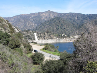
2:02 PM - I pass by the locked vehicle gate and begin hiking up the long-abandoned Silver Fish fire road (2N28). A narrow footpath furrows through the fresh green grass of winter. I wind in and out of patches of cool shade and warm sun. Cars pass along Hwy 39 below me. The mature chaparral that surrounds me is a patchwork of rich textures. As I climb higher the sparkling blue water of Morris Reservoir dominates the foreground to the east while Glendora Mountain dominates the skyline to the northeast. It’s still a month to the beginning of spring, and about the only thing in bloom are the clusters of white and lavender flowers on ceanothus, a large bush that typifies the chaparral.


2:14 - Reach the outward bend where the trail begins to contour into Water Canyon. But for today’s hike I turn left (west) and begin to climb the hogback ridge which goes straight up the mountainside. The first 150 yards are quite steep so I plod along slowly until the route mellows out some. Soon the snow-capped summit of Mt. Baldy pokes above the northeast ridgeline as the first fruit of the entire high country from Ontario Peak to Hawkins Ridge which will shortly follow. Brushy plants hug the narrow path and I’m thankful for long pants.

2:34 - Cross the first switchback of the old fire road coming up from Water Canyon. I continue climbing the ridge. A lone pair of tennis shoe prints indicates that someone has descended this route recently. Aside from the noise of an occasional motorcycle on the highway far below, there is a real peacefulness here. Silver Mountain looms above me to the north. I’m working up a mild sweat in the warm sun. At 2:56 I reach the second switchback of the old fire road and continue up the ridge. Now the high country panorama to the east stretches from Ontario Peak to Iron Mountain.
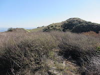
3:10 - Reach the upper ridge, greeted by a stiff breeze from the west. I turn left (south) and continue my climb on the ridge that divides the San Gabriel Canyon on the east and Roberts Canyon on the west. Shortly I get my first view of the ocean reflecting the late afternoon sun on the distant southwest horizon. Soon I achieve a knob on the ridge with a view toward my destination. The route gently drops to a saddle and bends around to the west. I take careful steps on the soft, uneven earth that has been excavated by gofers. In the summer and fall, weedy, dead grass would menace unprotected socks with foxtails and burs. I climb the final pitch to a knob where I see the summit 100 yards ahead.
3:34 - Summit 2843. This is my fifth time on this peak. It’s a special place for me since it predominantly occupies the mountain scenery that rises to the north of my home in Azusa. Most valley dwellers probably have never given the peak a thought as it would appear to be just another welt among the undulating sprawl of the San Gabriel Mountains. But for me, I’ve always had the curiosity of an explorer. When I see a summit, I wonder if it has a name and if there is trail to it. What’s it story? For years, this peak had beckoned me up.
So finally, after a couple exploratory excursions on 2N28, with topo map in hand, I set out with my friend Drew to conquer this pinnacle on May 22, 2004. It’s always fulfilling to stand on a peak, particularly one that I have scouted and set out to conquer without any guidebook or formal trail. At an elevation of a mere 2,843 feet, this peak is not a grand summit, but it’s my summit, and I enjoy an occasional visit.
Today I am rewarded with good visibility as I scan the 360-degree panorama. Vast human sprawl dominates the south, and the rugged Angeles National Forest dominates the north. Dozens of familiar peaks in view bring memories of many satisfying ascents. Snow-capped mountains rising to 10,000 feet speak of winter, and the warm sun and sparking Pacific Ocean speak of Southern California. And I have this summit all to myself. I love it!

3:55 - Say goodbye to Summit 2843 and retrace my steps back.
 and Silver Mt. (right, 4539')")
As the photographer’s “golden hour” sets in, I am eager to capture the scenery in a different light. A pair of red-trail hawks soar and swoop.
4:12 - Reach the ascending/descending ridge junction. As I turn east, I leave the direct sun and begin my descent into the mountain shadows. There is still some sun on the ridge well below me, but it will be gone by the time I’m there. I savor the beauty and peacefulness of the rugged scenery. The downhill climb is comfortable. I ponder the phenomenon that on a gorgeous day in SoCal, swarms of hikers will crowd the popular trails and I’ll have a splendid setting like this all to myself.

At 4:20 I cross the upper occurrence of the fire road and at 4:36 the second. I pause to photograph a lone occurrence of everlasting in bloom, about the only herbaceous plant I’ve seen in bloom all day. I take intermittent pics of Mt. Baldy and Morris Dam in the warm light of the setting sun as I try to capture the perfect shot. At 4:50 I begin my climb down the steep section. I admit that I’ve had a little angst in anticipating the pain-inflicting possibilities of feet sliding from under me. Thankfully I negotiate the slippery slope without incident and arrive back at the fire road in nine minutes.
I relax now as I saunter along the gentle, grassy path. It’s cool in the canyon shade as the orange glow of the setting sun lingers on the adjacent ridgeline to the east. The dead stalks of fennel standing taller than I show new growth at their base. Cars winding along Hwy 39 below welcome me back to a mechanized world.
5:17 - End Hike. The car thermometer reads 52 degrees.
Epilog - I am always indeed thankful for the gift of living so close to such a wonderful recreational treasure and having the wherewithal to hike. There are folks in parts of our country today being hammered by snow storms, but I get to wear a short-sleeve shirt and venture into the rugged mountains under sunny skies. What a blessing!
 See Summit 2843 hike description on Dan's Hiking Pages
NEXT > Summit 2843 via San Gabriel Canyon Hike - February 21, 2015
See Summit 2843 hike description on Dan's Hiking Pages
NEXT > Summit 2843 via San Gabriel Canyon Hike - February 21, 2015


 At 4:20 I cross the upper occurrence of the fire road and at 4:36 the second. I pause to photograph a lone occurrence of everlasting in bloom, about the only herbaceous plant I’ve seen in bloom all day. I take intermittent pics of Mt. Baldy and Morris Dam in the warm light of the setting sun as I try to capture the perfect shot. At 4:50 I begin my climb down the steep section. I admit that I’ve had a little angst in anticipating the pain-inflicting possibilities of feet sliding from under me. Thankfully I negotiate the slippery slope without incident and arrive back at the fire road in nine minutes.