Around the Rim
I started the hike at Hollyridge Trail, walked on the dirt road briefly, then climbed north up the ridge to Mulholland Ridge, east to Mt. Chapel, Bell Knoll, Mt. Bell, and Baby Bell. I finally had to use a section of dirt road south to Mt. Hollywood. Then back on a use path straight down the west ridge, past Captain’s Roost and continue down the ridge over a couple prominent high points, and then all the way to Bronson Cave by sunset. A short walk on the road north took me to a use path that climbs west straight up the mountainside to a ridge and then the final pitch to return to Hollyridge Trail. What an enjoying trek!
 Hike Description - If you’re looking for something different in Griffith Park, this loop is a winner. It would be good to have some familiarity with the park trails and competency in navigation, and some skill in negotiating dicey sections of trail. If you’re up to the challenge, you’ll find this hike to be rewarding. The whole loop is 4.1 miles (2.8 on trails and 1.2 on roads) with about 1900 feet in total evaluation gain. I’ve included enough detail in this blog narrative to give the specifics of how to do the hike. My Mt. Lee hike description will give you directions to the trailhead and the beginning of the hike. My Brush Canyon hike description fills in various details of hiking around the rim. Hike Description - If you’re looking for something different in Griffith Park, this loop is a winner. It would be good to have some familiarity with the park trails and competency in navigation, and some skill in negotiating dicey sections of trail. If you’re up to the challenge, you’ll find this hike to be rewarding. The whole loop is 4.1 miles (2.8 on trails and 1.2 on roads) with about 1900 feet in total evaluation gain. I’ve included enough detail in this blog narrative to give the specifics of how to do the hike. My Mt. Lee hike description will give you directions to the trailhead and the beginning of the hike. My Brush Canyon hike description fills in various details of hiking around the rim. |
 I leave my office in Echo Park at 1:50, take the 101 north to the Gower exit, and drive north on Beachwood Canyon Drive 1.9 miles to Hollyridge Trail trailhead. There are lots of cars but I find a place to park. Every time I’ve hiked from here my destination was Mt. Lee, but today I’ll go the opposite direction.
2:10 PM - Begin hike climbing Hollyridge Trail, a wide dirt road. It starts heading south and shortly cuts back north. Just past the junction where the road comes up from the horse stables, there is a path that veers left and heads up the ridge. This will be my route. I had scouted it out using the aerial view in Google maps. It showed a clear route. Up I climb. The foot traffic and erosion has created a trench. I’m literally climbing up a rut that’s 3 to 4 feet deep. But it works. After a few minutes I pass over Mulholland Trail (a wide dirt road) and continue up the ridge. This is a section Jerry Schad describes in his “Trip 4, Mulholland Ridge,” which helped inspire this hike. It’s pretty warm and I’m working up a sweat. Shortly a spur trail cuts left about 100 feet to Mt. Lee Drive. This makes a great alternative route to hiking to Mt. Lee. I continue up the ridge.
 2:31 - Mulholland Ridge. This highpoint offers a nice panorama, but the thick marine haze, particularly to the south, makes for poor visibility today. I see horseback riders on Mulholland Trail far below. I turn right (east) and stroll along the ridge trail with nice views north and south with Mt. Chapel up ahead. As I approach the flank of Mt. Chapel the trail splits. The right path traverses the south face of Mt. Chapel. I veer left and in a couple more minutes is another trail junction. The path straight proceeds northeast to the summit. It’s a good route, but for today, I turn left (north) and follow the trail along the west flank of Mt. Chapel heading toward the water tank. I’ve not walked the route before. It’s not bad but there are some dicey spots. I arrive at the water tank and walk past it on the right. Great view toward Burbank and Glendale. I turn right and climb the path south to the summit.
 2:54 - Mt. Chapel (1614’). This peak offers a splendid panorama of the park’s interior and the human sprawl beyond. The marine haze renders downtown virtually invisible today. The cool breeze feels good. Mt. Bell, Baby Bell, and Mt. Hollywood dominate the horizon to the east. Keeping with my plan to use narrow trails today, I head down the path due east. It’s pretty step and slippery, but I’ve climbed down it once before so I know what I’m getting into. Soon it mellows out and it’s a nice walk to meet the road that heads to the water tank on the north ridge of Mt. Chapel (the easiest route). I turn right (east) and walk on the dirt road 150 feet to Mt. Hollywood Drive. Now for another path I’ve not used before. Walk 100 feet north on the paved road to the use path that climbs east up the ridge (just short of the intersection of Vista Del Valle Drive). It’s a good path and a 3-minute walk to the summit.
 3:14 - “Bell Knoll” (as I call it). This is a little hill west of Mt. Bell. I continue on the path and in 3 minutes reach the saddle and junction west of Mt. Bell. I bear left (northeast) and in 50 feet turn right on the use path that heads up the slope (the northwest approach). There’s a web of paths but since I’ve been up this way a few times before, I choose well and have a nice climb.
 3:26 - Mt. Bell (1582’). This is my most visited peak in Griffith Park, so I guess that makes it my favorite. It’s in the heart of the park and can be approached from all directions. Its pointed summit offers great views. Across the canyon south, Mt. Hollywood calls to me. I leave the summit at 3:30 and take the path that heads southeast. It’s rocky and steep to start but then gets decent. A man passes me on his way up...my first use-path human encounter since passing a young couple on Mulholland Ridge. There is really quite a bit of solitude when one sticks to the narrow trails. A 4-minute descent delivers me to the road at the saddle between Mt. Bell and Baby Bell. Walk east on the road about 130 feet to the use path that bears right heading southeast. Another 4-minute climb gets me to the summit.
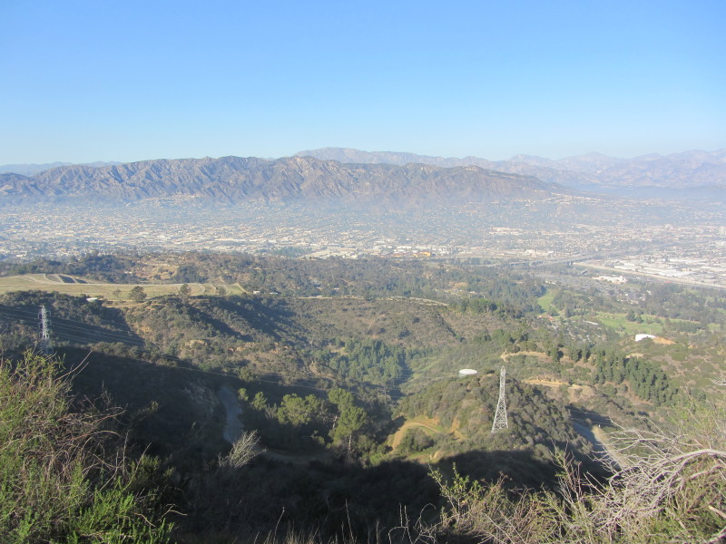 3:39 - “Baby Bell” (1570’). I’m still trying to find the story behind the hexagon shaped concrete structure that appears like it used to be the foundation of some type of gazebo or pergola. To the west, the haze backed up against the south side of Mount Lee gives a strong visual indication of how this range blocks much of the marine layer from the San Fernando Valley. I leave the summit at 3:45 and head down the ridge south. Partly down the ridge a spur path heads to the left meeting the trail coming around Baby Bell, but I continue straight. It gets pretty steep and slippery. I reach the dirt road at 3:49. This will be the first extended section of road since the beginning of the hike. I ascend the broad dirt road along the ridge, now sharing the park with other foot traffic. I soak in the beauty of the scenery. The sun still lights up Bee Rock below me to the east. When I get to the junction I turn left and walk toward Dante’s View to check out a use trail that comes up a ridge from Vista Del Valle Drive. Back to the junction I turn left (south) and finish my climb to the summit.
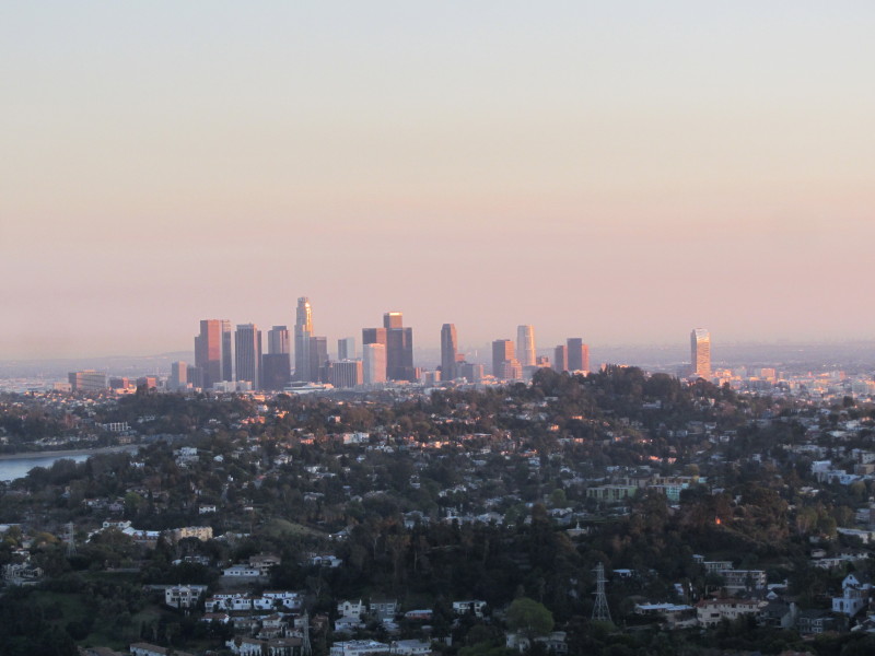
  4:07 - Mt. Hollywood (1625’). There’s about a dozen people and a few dogs here. The iconic peak offers great views, but today everything to the south is choked with a blanket of haze. The Hollywood sign stands silhouetted to the west. To the east, Hogback Peak and Glendale Peak, where I was last week, bask in the late after noon sun. My camera battery dies (I realized at the office today that I had neglected to pack my charger and backup battery), so now I’ve got to shoot with my iPhone. I’d like to linger longer but I still have a lot of cross country ground to cover before a 5:44 sunset.
 Leave summit at 4:20 and head down the steep path west toward Captain’s Roost. It’s really slippery and I fall on my butt. I carefully work my way down and reach the road in 5 minutes. Captain’s Roost was incinerated with the May 2007 fire. It’s now been rebuilt but it will take years to revegetate. Stately palms with blackened trunks rise into the sky. The gentle path continuing west down the ridge is quite nice. There are some century plants, ice plants, and other domestic vegetation along the way. This trail makes a much nicer route to Mt. Hollywood than walking up a dirt road. After 7 minutes I reach the road about 300 feet east of the hairpin turn. I walk to the turn and continue west on the path down the ridge. It’s only about 360 feet from this point to Mt. Hollywood Drive but the hillside drops much fast then the ridge, leaving a steep climb down the road cut at the end.
 Cross the street and start walking down the dirt road southwest. In about 275 feet I bear right onto a use path roughly paralleling the road. After a few minutes of climbing I arrive at a prominent outcropping. Then down to a saddle and up to another outcropping. I see hikers on the trail in Brush Canyon far below to north. The scenery is splendid and worth a return visit when the visibility is clean and there’s more daylight. I leave the ridge and a steep descent delivers me to the ridge route that is about 240 feet west of the big green water tank (#116) at 5:09. I’m getting a little nervous about the waning daylight and know I don’t have time to lollygag. I head down the ridge, a route I’ve hiked before. In a few minutes I reach the crest of the east quarry wall and get my first view down toward Bronson Caves. A film crew is wrapping up for the day. Down the ridge I climb, reach a saddle, then climb to a high point on the south crest of the quarry. The path bends north and requires some route choices as I negotiate my way west down the brushy hillside and reach the road culminating at the Bronson Cave site at 5:36. I snap a picture of the famous “Batcave.”
 I walk from the caves down the dirt road north to Canyon Drive in Brush Canyon. When I reach the road I bear right and continue north past the parking lot and park gate. My task now is to find the use path that climbs 460 vertical feet west to Hollyridge Trail. I get out my aerials to confirm the route. The sun is down now so I have no margin of navigational error in the diminishing light of dusk. I walk just short of 0.2 mile and locate the rough path on the left, adjacent to the concrete check dam. I begin my final climb at 5:49. It’s steep and loose but I manage to achieve a ridge in 7 minutes. I turn right (north) and ascend the ridge bending northwest, climb a final steep pitch, and arrive at Hollyridge Trail at 6:04. I’m feeling a sense of relief that I’ve made it successfully. Across the road is a large flat spot. A photographer and his friend have set up a pinhole box camera to capture the Hollywood sign in the twilight. I stop and chat and savor the beauty of the lingering sunset colors. The lights of Hollywood twinkle as crews work to get set for Oscar Sunday. My pace is relaxed as I walk the final 200 yards down the dirt road to the Hollyridge Trail trailhead.
6:17 - Done and fulfilled. I’m so ready for a warm shower and a good meal.
Epilog - What a thoroughly enjoyable adventure in Griffith Park. To complete a hike with about 70 percent of the route on narrow trails in a park dominated by dirt and paved roads is most satisfying.
(includes links to my other blog posts for hiking in Griffith Park)
(Detailed trail guide including driving directions, recommended season, map, notes, links, and photos)
- Mt. Lee - The Hollywood Sign - via Hollyridge Trail
- Brush Canyon to Mt. Bell (1582’) with options to Mt. Hollywood, Mt. Chapel, Mt. Lee, and Bronson Caves
- Brush Canyon to Mt. Bell at Dan's Hiking Pages - Hike report: May 6, 2010
- Griffith Park Six Peaks Hike - August 5, 2010 - including Bee, Chapel, Bell, Hollywood, Glendale and Beacon
- Mt. Hollywood, Mt. Bell Hike - 10-10-10
- Mt. Lee and More in Griffith Park Hike - March 9, 2011 - including Mt. Hollywood, Mt. Chapel, and Cahuenga Peak via Griffith Observatory
- Mt. Bell and Mt. Hollywood in Griffith Park Hike - Oct. 6, 2011 - via Vermont Tennis Courts and Hogback Trail
- Hollywood and Bell via Brush in Griffith Park - April 12, 2013
- Chapel, Lee, Cahuenga via Brush in Griffith Park - April 18, 2013
NEXT > Griffith Observatory Space Shuttle Hike - September 21, 2012
PREVIOUS > Hogback, Glendale, Beacon in Griffith Park - Feb. 17, 2012