Sunday, July 31, 2011

Rincon Road Hike - July 31, 2011

Rincon RoadSee Rincon Red Box Road to Summit 2908' Hike Description at Dan's Hiking Pages

I awoke at 4:40 AM on Sunday. Time to go hiking. Am I a diehard? I went hiking the last three Saturdays, so I knew that I needed to spend this Saturday on household chores, and it was a productive day. When I went to bed I told myself that if I woke up by 4:30 I’d go on a hike. And 4:40 was close enough. It would be a scrappy hike since I needed to be home by 9:30 before church. I coined the term “scrappy hike”--a hike which I generally define as being close to home, one which I have hiked numerous times, and one which I fit on a scrap of carved out time. A scrappy hike is just a way to get me outdoors and to get in or stay in condition for a primetime hike.

Rincon Road trailheadRincon Road (2N24) seemed to be the ideal scrappy hike for this morning. The trailhead is about 20 minutes from my home in Azusa up Hwy 39. I drove by the trailhead last Saturday en route to and from Crystal Lake and noticed that a Station Fire closure sign was still up, even though it is well out of the current Station Fire closure area as shown on the current FS map. I called the FS this week and they confirmed it is indeed open--at least for hiking and bicycling.

Rincon Road5:50 AM - Begin hike. The car thermometer reads 67 degrees. The sky is cloudy. My pace is fast since the major purpose for the hike is to put 7 miles on my legs and be back to the car by 9:10. The flora story of the morning is California buckwheat--lot of the creamy white flowers in bloom.

I’m generally not a fire road kind of guy when it comes to hiking, but sometimes you just have to hike on what’s available, particularly for a scrappy hike. On nice thing about a fire road is that you can walk at a fast pace and still be able to look around and enjoy the scenery without worrying about stepping off the trail and tumbling down the mountain. Another nice thing about fire roads is that the surface often makes a nice canvas to capture tracks. This morning I see various tracks including deer (with a fawn), large animal (maybe mountain lion), small animal (maybe raccoon), snake, human (in shoes), bikes, and motor vehicles.

Rincon RoadI love the beauty of the morning. Quall flutter through the brush. A rabbit sitting in the middle of the road watches me for a long time as I approach before he hops away. I am surrounded by mature chaparral, thick and richly textured. Only a few occurrences of Spanish broom are still in bloom with their beautiful and fragrant yellow flowers--now most of the plants are covered with bean pods. I snap pics along the way but have to be deliberate in keeping an earnest pace since the clock is ticking. I see my destination far up the canyon. The road climbs steeply. I’m working up a sweat. The varied clouds make a picturesque sky and create a purplish din on the high country to the north and east.

6:38 - Hairpin turn passing over the main canyon watercourse a couple minutes past Fern Springs. Heading northeast now along the east wall of the canyon. Pass the 2-mile marker at 6:43.

Rincon Road6:55 - Hairpin turn at 2.5-mile point. Splendid views. Linger long enough to get pics in all directions. I wonder about the prominent peak due east. It would offer superb views into San Gabriel Canyon but would require serious bushwhacking through steep terrain to get there. As I continue it begins to lightly sprinkle. I resist digging out my poncho. Pass 3-mile marker at 7:11. Still sprinkling.

7:19 - Arrive at the canyon head and the off-trail junction to the ridge and Summit 2908, my destination. The route is considerably more overgrown than when I was last here in April 2007, so I decide to continue up the road on ground I’ve not covered before. Not sprinkling any more. Up ahead I spot a water tank on a spur ridge and figure that it would be a good turn-around point.


View southeast from Madrone water tank toward the
canyon head and Summit 2908

7:32 - Arrive at Madrone water tank. The slightly concaved top of the cement tank catches rain water to be stored for use in fighting fires. I’d love to continue north another half mile to an outward bend that would certainly yield some striking views, but a scrappy hike does not yield much time for exploring. I calculate I’m at an elevation of about 2,860 feet, so a gain of 1,300 feet in 3.5 miles has been a descent workout. Start back at 7:44. I have about an hour and 25 minutes to cover 3.5 miles. It’s doable. My pace is steady.
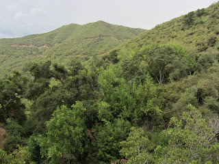
Rincon Road8:02 - 3-mile marker. Soon the sun pokes through the clouds a little. Pass the 2.5-mile turnout point at 8:13 and the 2-mile marker at 8:23. Better lighting now for pics. Pass 1-mile marker at 8:44 (actually it’s just a surveyor stick right now; elev. 2,039; I don’t know if they will replace it with a permanent marker). I’m on pace for being back on time. Pass a couple bikers heading up the road; one guy has a machete.

9:05 - Done with time to spare. No other vehicles at the trailhead, so I wonder where the bicyclists came from. Thermometers says 73 degrees. Still cloudy with some sprinkles on my car.

Epilog - What an enjoyable scrappy hike! The freshness of early morning. Pleasant weather. Clouds that restrained their precipitation. Beautiful scenery. Good workout. And nearly 7 miles of total solitude in the busiest National Forest in the country. icon

See Rincon Red Box Road to Summit 2908' Hike Description at Dan's Hiking Pages
 

Saturday, July 23, 2011

Mt. Islip Hike - July 23, 2011

Mt. IslipWith Hwy 39 to Crystal Lake Recreation Area being reopened in March 2011 after more than eight years of closure, the trails are now accessible to the general public. In September 2002, the Curve Fire destroyed more than 20,000 acres of the Angeles National Forest, including much of the Crystal Lake basin. The following year I hooked up with the San Gabriel Mountains Trailbuilders, who had special access to the Crystal Lake area to restore trails. I was haunted by the horrific fire damage. What used to be a mature pine forest with huge trees reaching to the sky was turned into a moonscape with charred sticks. It was in that context where I made my first hike to Mt. Islip via Windy Gap Trail on September 6, 2003, one year after the raging inferno. The scene I saw was surreal and eerie. I was overwhelmed with sadness to see such a terrible loss.

Over the years since than I’ve been on numerous work days with the Trailbuilders restoring and maintaining the trails. And I have watched life return. Today there is still an eeriness to the area as thousands of dead trees lay strewn upon the mountainside as from an explosion of giant pickup sticks. But the breathtaking landscape of the Crystal Lake basin and its towering ridges and peaks provides a rewarding experience. So today I set out to re-conquer 8250-foot Mt. Islip (pronounced “eye slip”).

7:43 AM - Arrive at the visitor center at the hub of the Crystal Lake Recreation Area. It’s a brisk 54 degrees. The gate for the road that continues onto the Windy Gap Trail trailhead is locked. I don’t know why that is, so I linger until the visitor center opens at 8:00. The gentleman tells me that that portion of the campground is closed and so I will have to walk the extra half mile to the trailhead. I’m bummed. That will add another mile to an 8-mile hike. At 8:05 I leave the visitor center and start walking up the paved road through the campground.

Windy Gap Trail trailhead8:15 - Start my hike on Windy Gap Trail (5830’). The sign reads 1.2 miles to Big Cienega Trail and 2.5 miles to Windy Gap. I’m excited as my boots hit the trail in the solitude and coolness of the morning. Shortly, a deer poses for a picture. At 8:27 I complete my first 0.4 mile as I reach the first crossing of the South Mt. Hawkins Lookout Road. I cross the road and continue up. Without having much foot traffic on it, the trail has a rustic feel to it. The Curve Fire had spared much of the forest at the heart of the Crystal Lake campground, but as I climb higher the legacy of the fire leaves a very different landscape. Dead trees are everywhere. But there is a beauty here. At 8:53 I reach the second occurrence of the road, 1.1 mile from the start. This is the location where the Trailbuilders park to do trail maintenance. I linger for a few minutes.

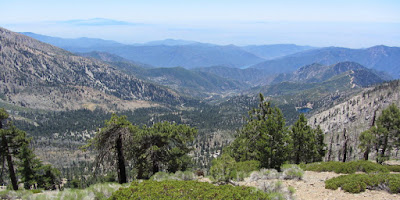
View South from Windy Gap Trail9:03 - Leave the road and continue up the signed Windy Gap Trail (6560’). In a couple minutes I pass the junction to Big Cienega Trail, which I have planned for my return route. There is a beauty to the expanding views. I can see Windy Gap high on the ridge to the north. This trail brings back lots of Trailbuilders memories as I pass various places I’ve worked on. At 9:10 I encounter the first of many downed trees that are yet to be removed from across the trail. I start noting their occurrences and will have counted 19 before reaching Windy Gap. A marine layer highlights the distant horizon to the south, but the visibly surrounding me is vivid. My pace is slow as I soak in the beauty. The scant number of living trees is a stark reminder of a majestic forest that used to cover these mountainsides. I negotiate the two switchbacks that are needed to keep the trail grade reasonable for final pitch.

Windy Gap10:25 - Arrive at Windy Gap (7588’). It’s quite breezy here, hence the name. I have the gap to myself for one minute until the first of several runners pass coming down the trail from Hawkins Ridge and heading toward little Jimmy. It’s the annual 100-mile race from Wrightwood to Pasadena. That’s nearly four marathons! That boggles my mind. A large group of hikers arrives from little Jimmy and head east. I rest, have a snack, and study the map and trail descriptions as others come and go. The foot traffic here is a striking contrast to the solitude I enjoyed on my ascent.

View toward Windy Gap and Hawkins Ridge10:50 - Leave Windy Gap and head to west to Mt. Islip. The sign says 0.8 mile. The Curve Fire had been stopped on this ridge, so now it feels like a real forest here. I love the smell of pine. Cars and motorcycles on the Hwy 2 below create a new soundtrack for this portion of the hike. The desert to the north comes into view. At 11:00 I reach the junction that comes up from Little Jimmy. The sign reads 1.2 to Mt. Islip, which is an obvious discrepancy from the sign at Windy Gap which reads 0.8. The trail cuts back south and soon I have nice views south from the ridge. The scenery is stunning as I ascend the ridge.

11:32 - Arrive at the junction on the south flank of Mt. Islip. To the left is Islip Ridge Trail, which I plan to take on my return trip. Other hikers pass. I stay right and continue to the summit. A switchback turns me east and shortly the trail cuts back to the north face and in another minute I arrive at the peak.

View south from Mt. Islip
11:45 - Mount Islip (8250’). What a great peak with awesome views! Another hiker arrived a moment before me and I have him take my picture. A group of others arrive. I sign the peak register, have some lunch, study my map, and soak in the far reaching vistas. The weather is fantastic. When the group leaves I take advantage of the alone time to take a 360 degree panorama. Soon another group arrives and so I figure it’s time to go.

Islip Ridge12:50 - Leave Summit. Pass more hikers en route to the peak. This is a popular destination today. Back at the junction on the south face of Islip I turn right (southwest) and begin my descent via Islip Ridge Trail. It’s immediately apparent that the trail gets less traffic. The white blossoms and shiny, dark green leaves of yerba santa dominate the flora scene. The rugged landscape and sweeping vistas are stunning. The fire was stopped on this ridge also, so there is a clear demarcation between the incinerated Crystal Lake basin on the left and the green-forested Bear Creek canyon on the right.

Islip Ridge TrailI think of the trail beneath my feet that was constructed by the San Gabriel Mountains Trailbuilders and dedicated with a grand opening celebration on September 29, 1990. Today I am grateful for their efforts as I soak in the magnificent scenery and appreciate being able to take a different route back. II spot a group of hikers far below coming up the trail. Soon I learn that they are coming up from Big Cienega Trail. There are couple spots where I have to figure out the route negotiating fallen trees. After two big switchbacks the ridge flattens out some.

Looking toward Windy Gap from Big Cienega Trail1:37 - Arrive at Big Cienega Trail junction (7580’). Islip Ridge Trail that continues south down the ridge appears to be completely gone at this location. It might reappear beyond the jumble of downed trees, but I suspect that it gets very little traffic covering the 3.9 miles from Crystal Lake. I turn east and begin following Big Cienega Trail, which travels 1.8 miles to intersect Windy Gap Trail. The path is disappearing from lack of maintenance. There are a number of downed trees that require climbing over or around. It’s easy to focus on the downed trees without noticing the dozens of trees that have been cut away to provide a clear path. I’ve worked with the Trailbuilders at various times on this trail and recognize that some of those trees were cleared with my help.

Big Cienega TrailI suppose that one advantage of a tooth pick forest is that it allows sweeping views of the entire basin. After a couple big switchbacks some live trees begin to grace the landscape. It’s nice to have a little shade and see pine needles on the ground. Pass some spots with rich vegetation. Getting warm now. I reflect on the fact that I have never been on these trails without being with the Trailbuilders doing trail maintenance since general public access has been restricted for more than 8 years.

Black Bear2:53 - Junction with Windy Gap Trail. In another minute I come face to face with a black bear standing in the road. What a treat! It’s only the second bear I’ve seen in the wild (the other was here at Crystal Lake in August 2003). I start shooting pictures; he poses nicely. He eyes me but doesn’t seem eager to run away. I move down to road and he moves a little further away. Finally I leave him, cross the road and start down the trail. Then I notice him moving down the road toward me. I suspect I had been positioned between him and the direction he had intended to travel. I snap a few more shots and say goodbye. As I walk I keep checking over my shoulder just to make sure he’s not coming after me. The last 1.1 mile is uneventful and the increasing shade is welcome.

3:37 - Windy Gap Trail trailhead. I made it! Now another half mile down the paved road to my car parked at the visitor center. I’m eager to have a hamburger and coke from the snack bar.

Epilog - What a great hike! Spectacular high country, amazing weather, fine trails, some solitude, a splendid peak, breathtaking views, lots of Trailbuilders memories, wildlife encounters, safe steps, a healthy body, and a hamburger and coke to punctuate the day. icon

camera See slide show of a Trailbuilders workday on lower Islip Ridge Trail - July 17, 2004

See Hike Descriptions at Dan’s Hiking Pages
(Detailed trail guides include driving directions, recommended season, map, notes, links, and photos)

Saturday, July 16, 2011

Lewis Falls Hike - July 16, 2011

Lewis FallsWaterfallsSee Waterfalls of the San Gabriels at Dan's Hiking Pages

See Lewis Falls Hike Description at Dan's Hiking Pages

After 14 years, I finally returned to Lewis Falls, which holds a unique place for me in my hiking history. On April 25, 1995, I purchased John Robinson’s Trails of the Angeles. This launched my personal Great Hiking Era of the San Gabriels. I immediately began to hit waterfalls: first Sturtevant, Rubio, and then Lewis on June 10, 1995. And that was one of those rare hikes where all three of my kids joined me. Then two years later, on April 13, 1997, we returned to Lewis Falls, this time my wife joined us, which turned out to be the only hike all five of us have ever hiked together in the San Gabriels.

Curve FireLewis Falls sat peacefully while I worked through the list of other hikes in Robinson’s book. Then on September 1, 2002, the Curve Fire broke out on a sweltering Sunday afternoon and quickly destroyed more than 20,000 acres of the Angeles National Forest, including much of the Crystal Lake basin. The beautiful Soldier Creek canyon, where Lewis Falls tumbles 50 feet over the rocks, sustained damage, but was spared the complete incineration that other areas experienced.

Because of the massive damage caused by the Curve Fire, The Forest Service and CalTrans closed Hwy 39 just above the West Fork. The public patiently, and not so patiently, waited for the reopening, which ended up being delayed year after year after year.

In June 2003, the year following the Curve Fire, I hooked up with the San Gabriel Mountains Trailbuilders, who had special access to the Crystal Lake area to restore trails. Over the years since then, I caravanned by the trailhead to Lewis Falls en route to perform trail maintenance at Crystal Lake, but never had the chance to stop and re-hike the trail.

On March 22, 2011 when I heard that Hwy 39 to Crystal Lake was finally reopened (yes, 8 ½ years of closure!), I was elated (or course!). I was eager to be reacquainted with Lewis Falls, but as life has it, the plans kept getting delayed. But alas, the time finally came.

Lewis Falls TrailheadThe Hikemasters hiking group, led by the Ray (“Peter Piper”), who I met this year at Fish Canyon Falls, were planning a hike to Lewis Falls. I asked if I could tag along and they were most gracious in welcoming me to join them. It worked out perfectly since I live a five-minute walk from Hwy 39 in Azusa and offered to have them pick me up at the corner of 9th Street and Hwy 39. They picked me up right on time at 7:43. I enjoyed good conversation with Ray and his wife Jocelyn during the 38-minute drive to the trailhead. The 12 of us piled out of 3 cars, took a group photo, and were ready to hike.

En route to Lewis Falls8:26 AM - Begin the hike. The trail is in decent condition as it traverses the right (east) side of Soldier Creek. We stroll under a canopy of cedar, fir, pine, maple, bay, alder, and oak. The beauty of the canyon exceeds my expectations. In a few minutes we pass the first of two cabins that survived the Curve Fire. Some of the blooming wildflowers that grace our hike include Humboldt lily, periwinkle (typical ornamental plant around cabins), scarlet penstemon, prickly phlox, California aster, wallflower, everlasting, California buckwheat, bush monkeyflower, creek monkeyflower, scarlet monkeyflower, canyon dudleya, scarlet columbine, phacelia, and mustard. There is a lot of poison oak and stinging nettle along the trail, which requires some vigilance to avoid.

The ruins of burnt-down cabins cause me to reflect on those who used to enjoy peaceful escapes to their secluded hideaways. And since the cabins pre-dated the designation of the National Forest, they are allowed to remain under a “grandfather clause.” But once the cabins are gone, they are lost forever.

Trail to Lewis Falls In the weeks prior to this hike I had read reports that fire, mudslides, fallen trees, debris, and disuse have obliterated the trail. So am I pleasantly surprised that the cabin portion of this half-mile walk to the falls is still in decent shape. There are places were we climb through fallen trees, but it’s not too bad. After the final cabin ruins, the route drops down to the creek bottom and we have to climb through a large jumble of fallen tree to cross the creek. Now on the west bank, the route is still manageable as the canyon narrows. Still vigilant to dodge stinging needle. We climbed over a large rock, which could pose an obstacle for those of diminutive stature if they had no assistance. Immediately after the rock, a large tree trunk spans the creek as a bridge. Several of our party carefully climb across the log, not realizing that it is a bridge to nowhere. The rest of us skirt along the steep bank on the left, drop back down to the creek, and in about 30 yards find ourselves at the base of Lewis Falls.

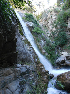
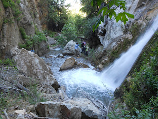
Lewis Falls9:04 - Arrive at Lewis Falls. It is still gushing quite well as we have had significant snowfall this past winter. To get the best view of the falls, which tumbles over the rock face on the west canyon wall, we have to cross over to the right side of the creek. A few well-placed rocks make crossing doable, but a misstep or loss of balance promises major wetness and possibly contusions and/or other unpleasant things to ones body. We all cross over safely.

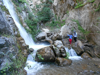
The literature lists the falls at 50 feet, including a top tier, which is mostly out of view from the bottom. The main falls courses through a narrow notch and cascades as a ribbon to a small pool. A fine mist dampens the area and makes footing slippery. I climb over a boulder and up the ravine to the right of the falls to get a better view. After a while the group begins to migrate back over the creek and so I climb down and am the last one to say goodbye to Lewis Falls.

Lewis Falls9:24 - Leave falls. The sun lightens up the canyon more on the return trip. I’m in the rear so my pace is more casual as I soak in the beauty and take pictures. We pass a family with several young children and two tiny dogs heading to the falls. The trip seems shorter than the way in.

10:04 - Finish hike.

Epilog - What a treat to revisit one of the easy-access waterfalls of the San Gabriels! It was easier than I had anticipated and more scenic. Years of closure has allowed the route to return to a more natural state. And I really enjoyed the company of a good group of folks. Thanks Ray, for letting me tag along. icon

WaterfallsSee Waterfalls of the San Gabriels at Dan's Hiking Pages

See Lewis Falls Hike Description at Dan's Hiking Pages

Saturday, July 9, 2011

Fish Canyon and Dudleya Densiflora - July 9, 2011

Fish Canyon Interpretive Sign See Fish Canyon Falls Hike Description at Dan's Hiking Pages

Summertime is not when I typically think about hiking Fish Canyon. To me it is a springtime hike. And I’ve already hiked it four times this year! But on Friday night I made the decision to do the hike if I wake up by 6:00 AM. Well I woke up at 6:00 on Saturday morning, thus the plan is to hike. My wife would be leaving at 7:30 to take my daughter to the airport, so I linger until my daughter got up so I could say goodbye.

A primary objective for the day would be to find the rare Dudleya densiflora (San Gabriel Mountains liveforever), which is reported to be growing on the steep rocky walls in the canyon. For years I’ve read about Dudleya densiflora on the interpretive sign en route to Fish Canyon Falls. On June 12 while taking a stroll along Old San Gabriel Canyon Road from El Encanto Azusa River Wilderness Park, I serendipitously had my first encounter with the rare plant. So I determined that it would be good to find the Dudleya densiflora in Fish Canyon.

Fish Canyon7:03 AM - Leave my house in Azusa on my bike. It’s a pleasant ride in the cool of the morning. As I approach the entrance to Vulcan Materials there are more than 20 cars lined up to get in. I roll by them and pass through the gate at 7:27 as the attendant jots down my name on the log. Lock my bike up at the office and pull away in a van at 7:36.

7:38 - Begin hike. I stay ahead of a group not too far behind me. This beautiful canyon has become a familiar friend. Not as much in bloom as in the spring, but the trees are in full leaf. Since my primary objective is to find the rare Dudleya densiflora, I proceed with a resolute purpose.

Habitat of Dudleya densiflora8:14 - Cross the creek and begin scanning the canyon walls for Dudleya densiflora. Bingo! At 8:15 I spot an occurrence of the rare plant 20 feet on the slope above. I don’t want to disturb its habitat. Moments later I pass through the blackberry patch and, eureka! I hit the mother lode of San Gabriel Mountains liveforever! I scamper around the rocks and take lots of pictures. Get lots of burs in my socks. The sun is unfolding on the slope so I get pics in both shade and sun.

Dudleya densiflora
Dudleya densiflora is a native succulent in the stonecrop family (Crassulaceae) and blooms from June to July. According to the interpretive sign lower on the trail, Dudleya densiflora was first verified in 1919 in Fish Canyon. This is a rare species that apparently only grows in several places in the front range canyons of the San Gabriels around the San Gabriel River. Dudleya densiflora is endemic, which means that it is native to only this specified geographic area. That’s pretty amazing to me, that of the entire planet earth, the only place this species grows is right here!

Dudleya densifloraIt generally is found in steep, rocky, granitic cliff and canyon walls from 800-2000 feet in elevation. According to Cliff and Gabi McLean, there are five species of dudleya in the San Gabriel foothills and canyons. Canyon dudleya (Dudleya cymosa) and lanceleaf dudleya (Dudleya lanceolata) are the most common and both occur in Fish Canyon.

After I shoot a gazillion pics, I continue up the trail to the falls. En route I carefully scan the canyon walls but see no more occurrences of Dudleya densiflora.

Fish Canyon Falls9:00 - Arrive at Fish Canyon Falls, in full sun now. Falls flowing nicely. Lots of people. Run into Chris, a gentleman I met here in May. Meet some other nice people. The crowds always give the site a kinetic energy. I am disappointed that someone had built another illegal fire since May.

10:00 - Leave the falls. Lots of people on trail. When I arrive at the creek crossing I notice some more Dudleya densiflora on the east wall just below the crossing. Climb closer for some pics. Stop by to see Darlin’ Donna Falls still flowing. Meet some more nice people en route. Wish I had the authority to punish dog owners who refuse to obey leash laws. Shame on them! Getting warm now. Meet up with a party I met at the falls and enjoy their company for the remainder of the hike.

11:46 - Finish hike and ride the van back to the parking lot, which is quite full. The attendant told me that the count was 532 people in 217 vehicles, which is the third highest count on record. Not sure if that counted my bike. Stopped by Costco on my bike ride home for a hotdog and soda.

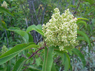
laurel sumacPlants in Bloom - The plants I observe in bloom that are featured on the Fish Canyon Trail Plant Guide include buckwheat, bush monkeyflower, sunflower, golden yarrow, mustard, tree tobacco, Spanish broom (not much left), phacelia, Botta’s clarkia (one occurrence, indeed farewell to spring), milkweed, everlasting, and matilija poppy. Other plants in bloom include laurel sumac (pictured above), toyon, thistle, cliff aster, California aster, lanceleaf and canyon dudleya, scarlet larkspur, creek monkeyflower, deerweed, white sage, honeysuckle, wishbone bush, and blackberry. I give scarlet larkspur the award for being the dominate flower for the day.

Epilog - Beautiful weather, nice people, good exercise, pleasing wildflowers, showy waterfall, splendid scenery...another thoroughly enjoyable outing in my beloved Fish Canyon. And finding the rare Dudleya densiflora was a real treat. icon

See Fish Canyon Falls Hike Description at Dan's Hiking Pages

Plants See Fish Canyon Trail Plant Guide (April 2011) (PDF)

Plants See Plants and Wildflowers in the San Gabriel Mountains at Dan's Hiking Pages
NEXT > Fish Canyon Falls Hike - April 7, 2012
PREVIOUS > Fish Canyon Falls Plants - May 28, 2011