
3:30 PM - Begin walking north on Hillhurst through a residential neighborhood. I’m still not sure what hike I am going to do but I have a little bit of a walk to think about it. After 18 minutes I arrive in Griffith Park at the intersection of Vermont Canyon Road and Boy Scout Road. I decided to hike the ridge route north to “Hogback Peak” (as I call it). I’ve looked at that route from various perspectives and have been eager to try it out. I’m not sure what I’ll do after that but I’ll make it up as I go.
 I walk up the road past the Greek Theatre to the trailhead for Riverside Trail on the east side of the road about half way between the theater and the Bird Sanctuary. It always amazes and maddens me that in the largest city-owned park in the country, they can’t scrape enough money together for trail signs. How hard would it be for them to put up a sign saying, “Riverside Trail?!”
3:55 - Begin heading east on Riverside Trail, which is actually a wide dirt road. It’s steep. Views soon open up. The air is cool and sun feels good. Shortly the trail rounds a hip of a ridge and heads into the next canyon. But my route is to cut north and climb the ridge on a narrow use path. I’ve seen people on this route so I know it’s doable.
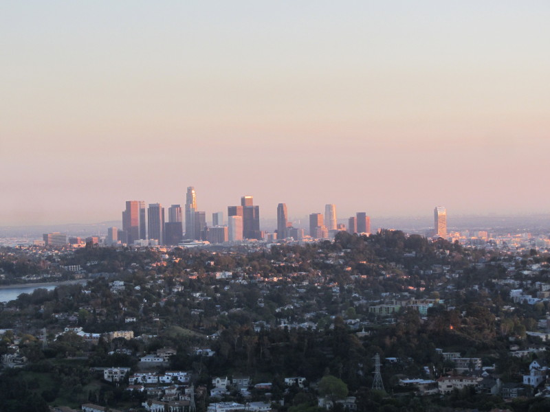
 4:00 - Begin ridge climb heading north. This area was burned in the May 2007 fire but the vegetation is coming back well and some healthy pine trees grace the landscape. The well beaten path climbs moderately up the gentle ridge offering views into the canyons on the east and west. It’s still winter, so there is not much in bloom...just a few occurrences of everlasting, mustard, Canterbury bells, deerweed. There’s a cool breeze. The clear sky affords a nice view of downtown L.A. to the south. I upload a couple photos to Facebook. As the route approaches the upper ridge, it get’s crazy steep. Thankfully footsteps have been hewn out of the crumbling granite making the climb doable.
 4:28 - Hogback Peak (1480’). This summit is not officially named, but since it is such a dominate highpoint on Hogback Ridge, the name Hogback Peak seems appropriate. I’m treated with splendid views of Burbank to the north, Glendale to the east, and the Los Angeles sprawl to south. Mt. Hollywood dominates the view west and the grand Griffith Observatory stands majestically to the southwest. The Pacific Ocean is as a sheet of glass reflecting the setting sun. I am not alone for long as a couple young ladies arrive, and then a couple men with dogs off leash. I estimate that about 20% of those who walk their dogs in the park don’t use a leash, a flagrant violation of a city ordnance (LAMC 63.44-B,2.C), which is clearly communicated throughout the park. I don’t know why these people think they are above the law and don’t extend the most basic courtesy to other trail users. Well, in spite of that, I’m enjoying an absolutely beautiful day.
 4:35 - Leave the summit and head east down Hogback Ridge Trail (aka East Ridge Trail). The San Gabriel Mountains dominate the horizon to the north and northeast. The afternoon sun casts a warm light on Glendale. Bee Rock, Old Zoo Park, and the other features of the northeast section of the park are in deep shade now. Other trial users are enjoying the beauty of the day. Parts of this ridge route, which is a wide dirt road, are quite steep and I take careful steps so as to not slip on the decomposing granite.
  Seeing the huge road cuts throughout the park prompts me to reflect on the environmental naiveté of past generations who horribly carved up such a wonderful open space. Likewise, the abandoned irrigation pipes running throughout the park testify to a mentality that didn’t appreciate the beauty and self-sufficiency of native plant communities.
Up ahead and below me I can see Glendale Peak basking in the warm sun. I cross the bridge and arrive at Henry’s Trail at 4:52. A trail sign (which is rare in Griffith Park) commemorates the trail to Henry Shamma, who maintained this trail for years. I head up the narrow path that follows the board ridge. My pace is brisk as the sun threatens to set.
 4:55 - Glendale Peak (1184’). Nice panorama! The breeze is cool and I put on long sleeves. I take a moment to soak in the scenery but don’t linger long. The last time I was here I attempted a shortcut heading east which ended short of the road forcing me to turn back. This time I decide to try the path that heads south.
Leave the summit at 5:02. The path is pretty steep with loose footing but it is clearly used. To my relief the route works and I arrive at the main trail at 5:07. It didn’t save me much of time, but it’s fun to explore different routes. In another couple minutes I arrive at the junction of Riverside Trail and Vista Del Valle Drive. Now I have an option. I can take Riverside Trail southwest and reconnect with Hillhurst to Los Feliz. But I decide to continue east to Beacon Hill. I love the warm light of the “golden hour”...so nice for photos. I’m walking now on the paved road lined with eucalyptus. I pass Joe Klass Water Stop, a nice roadside picnic area. After a few more minutes down the dirt road I arrive at Five-Points junction. I continue straight ahead east at a brisk pace hoping to summit Beacon Hill before the sun dips out of sight.
 5:26 - Beacon Hill (1001’). Vast human habitation sprawls out before me as night approaches. The downtown skyscrapers to the south glisten with the last rays of sun. The I-5 freeway below me is packed with traffic and creates an ever-present drone. I want to linger but need to keep going. The sun sets at 5:38 today. I decided to take another shortcut and follow the ridge to the south. I’ve not hiked it before but I know it goes through.
5:31 - Leave Beacon Hill and head south down the ridge. The use path is somewhat steep with loose footing in places, but not bad. I can see Lower Beacon Trail below me. The path mellows out and at 5:43 I arrive at Lower Beacon Trail. I decide to continue on the use path south down the ridge as a further shortcut. I’ve not hiked this route but the evidence of foot traffic suggests that it goes though. Soon the topography suggests that the final pitch will be really steep. Yup, it gets really steep, but branches of laurel sumac provide handles to help lower me down.
 5:51 - Reach the intersection of Coolidge Trail and Crystal Springs Drive, 13 minutes after sunset. I’m done. Coyotes begin to howl. A short walk south takes me to Los Feliz Blvd. where I sprint across the street to jump on a Metro 181 for the ride home.
Epilog - Very enjoyable outing in spite of the delays and a circuitous transit trip getting there. Clear skies, great views, warm sun, cool breeze, good exercise, pleasing scenery, and exploring new routes, made for a splendid hike. Griffith Park is a real treasure for Angelinos.
(includes links to my other blog posts for hiking in Griffith Park)
NEXT > Chapel, Bell, Hollywood, and Bronson - February 24, 2012
PREVIOUS > Burbank Peak, Cahuenga Peak, Mt. Lee - December 30, 2011
Looks like a great hike with a great view. Thanks for sharing.
ReplyDeleteNice adventure. Being able to complete a hike using public transit should count for double. ;D Funny thing is, I do recognize MTA 181, and thought to myself, "Hey, that one shoots all the way back to Pasadena." It's not a very FAST way to get from Hollywood to Pasadena, though! There used to be a 780 or 781 "Rapid" bus that ran from Hollywood to PCC, though that one may have been cancelled.
ReplyDeleteThat 780 Rapid still runs...I missed it by about 1 minute. But public transportation, no matter what they call it, is hardly rapid! :-)
ReplyDeleteI had always meant to do this hike when I worked in Hollywood. But I never did. I need to do it I think.
ReplyDeleteYou're awsome Dan. When I first started hiking i would use your website to find new hikes. It's a great resource. Thanks for doing what you do.
Thank you, Grae! I appreciate the affirming words.
ReplyDeleteWell, if you ever get a chance to get over to Griffith, you'll enjoy its rewards.